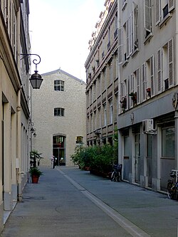
Cité de Magenta
| Cité de Magenta | |
|---|---|
| location | |
| Arrondissement | 10. |
| quarter | Porte-Saint-Martin |
| Beginning | 33, Boulevard de Magenta |
| The End | 3-4, Cité Hittorf |
| morphology | |
| length | 80 m |
| width | 4.5 m |
| history | |
| Emergence | January 22, 1868 |
| designation | January 22, 1868 |
| Original names | Cité Grange |
| Coding | |
| Paris | 5836 |
The Cité de Magenta is a street in the Porte Saint-Martin district of the 10th arrondissement in Paris . It is very close to the Mairie of the 10th arrondissement .
location
The Cité de Magenta begins at No. 33, Boulevard de Magenta and ends after a right-hand bend at No. 3–4 Cité Hittorf . The Cité de Magenta is still listed in the official directory of the streets of the city of Paris, although it is blocked off as a private street at both ends by a gate with a digital locking system and is also marked as “Voie privée” (private street).
The closest metro station is Jacques Bonsergent on the line .
![]()
![]()
Name origin
It bears the name in memory of the Battle of Magenta under Napoleon III. because of the proximity to the boulevard of the same name.
history
The street was opened under its current name by a decree of January 22, 1868 which, with certain reservations, approved the opening of the Cité de Magenta as an extension of the Cité Grange, which led to 78 Rue du Faubourg-Saint-Martin . After the Cité Magenta had overlaid the Grange City, it went from the Boulevard de Magenta to the Rue du Faubourg-Saint-Martin.
The part of Cité Magenta, which was previously called Cité Grange, with a length of about 112 meters became Cité Hittorf and the eastern part (46 meters) became Rue Hittorf in 1890 .
literature
- Jacques Hillairet: Dictionnaire Historique des Rues de Paris. Les Éditions de Minuit , Paris 1963, ISBN 2-7073-0092-6 .
- Laure Beaumont-Maillet: Vie et histoire du Xe arrondissement. Éditions Hervas, Paris 1988, ISBN 2-903118-35-3 .
Web links
Coordinates: 48 ° 52 '17.4 " N , 2 ° 21' 33.2" E

