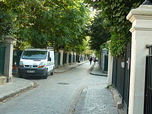
Cité des Fleurs

The Cité des Fleurs ("City of Flowers") is a 320 m long, tree-lined private street ( voie privée ) with villas in the 17th arrondissement of Paris .
history
In 1846, Ernest Goüin founded the railway and machine factory "Ernest Goüin et Cie" in the nearby village of Batignolles, which today forms one of the four quarters of the 17th arrondissement of the city of Paris. Appropriate living space was required for the almost 2,000 factory employees. In 1847, the landowners Jean-Edmé Lhenry and Adolphe Baqueville de la Vasserie merged their parcels in the Quartier des Èpinettes to form a two-hectare parcel called “Villa des Fleurs”. They divided the area into terraced house plots of equal size and sold them in 1850 with detailed, sometimes unusual building restrictions. These concerned the height of the two-story residential buildings, the alignment of the facades and the requirement for at least three trees per front garden. In September 1850 the street was renamed Cité des Fleurs . The first community of residents was established in 1857, on October 31, 1864, a separate police ordinance was issued and public transport was tolerated, and only in 1866 were all the parcels sold. The first water supply was established in 1865, the connection to the city sewerage system took place in 1898. Based on a law from 1901, a statute governed the owner's interests for the first time on June 12, 1907, when the first organized association of house owners was brought into being. In 1909, work began on the church of Saint Joseph des Èpinettes in the parallel street Rue Pouchet (No. 59). In 1869, Alfred Sisley, born in Paris, painted the oil painting “View of Montmartre from the Cité des Fleurs”.
The film actress Catherine Deneuve was born here on October 22, 1943, and her older sister, the actress Françoise Dorléac , was born here on March 21, 1942. On May 18, 1944, a resistance fighter from the Résistance was executed by the Gestapo at house 25 and six residents were deported. In that house there was a forgery workshop for documents.
Today, 32 houses and 20 condominiums are owned by 62 owners. They are united in the Association Syndicale Libre Cité Fleurs , which issued new statutes on January 1, 2011.
Transport links and location
The Cité des Fleurs is located in the Quartier des Épinettes ("Quarter of the spruce trees"). Access to the street is from avenue de Clichy or rue de la Jonquière . The street is not named in the official city map. It is blocked off from public transport by two iron gates at its ends. This makes it a quiet street in the middle of the hectic city, because only supply traffic is allowed. The Cité des Fleurs is located between Rue Navier in the north, Avenue de Clichy in the west and Avenue de Saint-Ouen in the east. In the Épinettes district that surrounds the street , 15,415 residents live on 492,000 m². The residential value in the street is among the highest in Paris and the prices are also high; a market value of around 1.5 million euros is estimated for a 229 m² villa.
Individual evidence
- ↑ Declic Le Bulletin, 2007 ( page no longer available , search in web archives ) Info: The link was automatically marked as defective. Please check the link according to the instructions and then remove this notice. (PDF; 132 kB)
- ↑ Mairie de 17eme Arrondissement ( Memento of the original from October 5, 2011 in the Internet Archive ) Info: The archive link was inserted automatically and has not yet been checked. Please check the original and archive link according to the instructions and then remove this notice.
- ^ Community of owners of the Cité Fleurs
- ^ Density Atlas
- ↑ Meilleursagents on house number 38
Web links
Coordinates: 48 ° 53 ′ 34.1 " N , 2 ° 19 ′ 13.4" E


