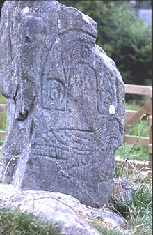
Clach to Tiompain
The Clach an Tiompain ( English Sounding stone or Eaglestone , German Adlerstein ) is a small, one-sided damaged Pictish symbol stone of Class 1 on a hill on the northern outskirts of Strathpeffer in Ross and Cromarty in the east of the Scottish Highlands . The stone was originally located further east towards Dingwall . It was moved to its current location in 1411. There is a menhir of the same name on the Isle of Islay .
description
The blue gneiss stone is 81 cm high, 61 cm wide and 25 cm thick. A horseshoe-like symbol is carved over an eagle on its southeast side . This processing dates from the 7th century.
classification
In "The Early Christian Monuments of Scotland" (1903) John Romilly Allen (1847-1907) and Joseph Anderson (1832-1916) classified the stones in three classes. Critics have noted weaknesses in the system, but it continues to be used. Class 1 are unworked stones with incised symbols. There are no cross representations. The stones date from the 6th to 8th centuries.
Tradition has it that the stone marks the location of a clan battle that took place in 1411 between Clan Munro and a branch of Clan MacDonald, and the stone commemorates a Munro victory as it is marked with its symbol, an eagle. The stone is also associated with the prophecies of the historically unproven Brahan Seer or Kenneth Mackenzie from the 16th century ( Scottish Gaelic Coinneach Odhar ). He predicted that if the stone fell three times, the surrounding valley would be flooded and the stone would serve as an anchor. It has fallen twice since then and is now embedded in concrete.
literature
- Alastair Mack: Field guide to the Pictish symbol stones. Pinkfoot Press, Balgavies 1998
Web links
- Entry on Clach an Tiompain in Canmore, Historic Environment Scotland's database
Coordinates: 57 ° 35 ′ 29 ″ N , 4 ° 32 ′ 8 ″ W.
