Clifford Bay
Coordinates: 41 ° 41 ′ S , 174 ° 11 ′ E

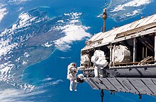
Aerial view, Cape Campbell is in the far west, possibly outside the picture. This South Island photo also shows Cloudy Bay , the mouth of the Wairau River , the White Bluffs , the Awatere River Valley and Clifford Bay, and Lake Grassmere from right to left .
The Clifford Bay is a bay in the northeast of the South Island of New Zealand in the region Marlborough . It stretches between the White Cliffs in the north, which separates it from Cloudy Bay , and Cape Campbell in the south, one of the three most easterly points of the South Island. Lake Grassmere and its salt flats are located near the southern end of the bay .
The New Zealand State Highway 1 runs about 5 km west of the bay and passes Seddon . Smaller towns near the bay are Hauewai , Lake Grassmere, and Blind River .
The Blind River and Awatere River flow into the northern half of the bay.
literature
- "New Zealand Travel Atlas", Wise Maps Auckland. ISBN 0-908794-47-9 .


