
Clinton, British Columbia
| Clinton | |||
|---|---|---|---|
| Location in British Columbia | |||
|
|||
| State : |
|
||
| Province : | British Columbia | ||
| Regional District : | Thompson-Nicola | ||
| Coordinates : | 51 ° 5 ′ N , 121 ° 35 ′ W | ||
| Height : | 887 m | ||
| Area : | 8.19 km² | ||
| Residents : | 641 (as of 2016) | ||
| Population density : | 78.3 inhabitants / km² | ||
| Time zone : | Pacific Time ( UTC − 8 ) | ||
| Postal code : | V0K | ||

Clinton is a civil parish in central, southern British Columbia , Canada . Clinton is located in the Interior Plateau and is part of the Thompson-Nicola Regional District .
history
Much of the local history is closely tied to the Cariboo Road (also known as the Cariboo Wagon Road or Great North Road ) and the Pacific Great Eastern Railway . The close connection of the community is evident in the original name of the settlement. Clinton's older name is 47 Mile House , referring to the distance here on Cariboo Wagon Road from the starting point in Lillooet . The current name of the village refers to Henry Pelham-Clinton , the fifth Duke of Newcastle-under-Lyne, who was British Colonial Secretary of State in the mid-19th century.
The granting of local self-government for the municipality took place on July 16, 1963 ( incorporated as Village Municipality ).
Demographics
The last official census , the 2016 Census , showed a population of 641 inhabitants for the settlement, after the 2011 census showed a population of 636 inhabitants for the municipality. Compared to the last census in 2011, the population only increased by 0.8% and thus remained basically unchanged. Contrary to the provincial average, it did not develop any further, as there was a significant population increase of 5.6%. In the census period from 2006 to 2011, the population in the municipality had decreased by 6.4% and was almost the provincial average, there by 7.0%.
At the 2016 census, the average age of the residents was 50.8 years, well above the provincial average of 42.3 years. The median age of the residents was determined to be 56.2 years. The median age of all residents in the province in 2016 was 43.0 years. For the 2011 census, a median age of 53.1 years was determined for the residents of the municipality and 41.9 years for the residents of the province. The population here is significantly older than in the rest of the province.
economy
The median income of Clinton employees in 2005 was C $ 19,380, while at the same time the average for the entire province of British Columbia was only C $ 24,867. The income gap between men (C $ 22,950; provincial average = C $ 31,598) and women (C $ 16,982; provincial average = C $ 19,997) is smaller in Clinton than in the income comparison for the entire province.
traffic
Highway 97, which connects the town with the rest of British Columbia, runs through Clinton in a north-south direction .
About 15 miles north-north-west of Clinton is the local airfield ( IATA : -, ICAO : -, Transport Canada Identifier: CBR4). The airfield has only a short asphalt runway, 1,302 meters long.
A stretch of the Canadian National Railway approaches from the west , which from Clinton largely follows the course of Highway 97 northwards.
Picture gallery
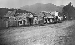
Clinton in 1918

Clinton Museum (2018)
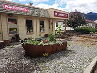
Liquor Stores (2018)
.jpg)
.jpg)
.jpg)
Web links
- Official website of the small town
- Clinton on britishcolumbia.com (Engl.)
Individual evidence
- ^ A b Clinton Community Profile. Census 2016. In: Statistics Canada . August 9, 2019, accessed September 4, 2019 .
- ^ Origin Notes and History. Clinton. GeoBC , accessed November 6, 2013 .
- ^ Clinton Community Profile. Census 2011. In: Statistics Canada . May 31, 2016, accessed September 4, 2019 .
- ^ Clinton Community Facts. (PDF; 48.05 kB) BCStats , accessed on November 6, 2013 (English).
- ↑ Canadian Airports Charts. (PDF; 29.5 MB) NAV CANADA , accessed on September 4, 2019 (English).