Compagnie des chemins économiques de l'Est égyptien

from Wikipedia, the free encyclopedia
Compagnie des chemins économiques
de l'Est égyptien
Line of the Compagnie des chemins économiques de l'Est égyptien
Route map
Route length: 350 km
Gauge : 1000 mm ( meter gauge )
Operating points and routes

100. DAMANHOUR-DEATH-TEH-EL-BARUD

  • Damanhour
  • Haganaya
  • Hafez Pasha
  • Abu-Massoud
  • Atlamis
  • Messin
  • Manshiet el Shorafa
  • Ittehad
→ Kom Feryn (branch line, possibly only freight traffic)
  • Ahmed Pasha Sadek
  • Delingat
  • Daoud
  • Abu-samadi
  • Death (Jonction death)
  • Riaz Pasha
  • Nagouri
  • Maania
  • Teh-el-Baroud (30 miles from Damanhour)

101. DEATH - DELINGAT

  • Death (see 100)
  • Biban
    • Kom Hamada (reallocation from 1927)
  • Kherbeta
  • Dest
  • Haddy
  • Kafr-Ziada
  • Wafaleh (22 km from Tod)
  • Kobour-el-Omara
  • Derchai
  • Abou coucha
  • Delingat (see 100)

102.DAMNHOUR - KAFR-EL-DAWAR

  • Damanhour (see 100)
  • Shoka Road
  • Fadel Pasha
  • Ezbet Salama
  • Nédiba
  • Yeasts
  • El Shousha
  • Kom-el-Akhdar
  • Momtaz
  • El Sharika
  • Hosh Issa
  • El-Riko
  • Ezbet-Neguilah
  • Nubar
  • El-Markeb
  • Abu-el-Matamir
→ Kom-Truca (branch line, possibly only freight traffic, 7 km)
  • Ghandoura
  • Gheta
  • Kom-Abu-el-Eda
  • Gaara
  • Kom-el-Hanash
  • Masraf Nubarieh
  • Omadieh (Sidi Ghazi Behera)
  • Ezbet Dawar
  • Kom-el-Birka
  • Ezbet Rafia
  • Wastaniya
  • Kafr-el-Dawar abc (77 km from Damanhour)

103.DAMANHOUR-SHIBRIKHIT-TEH-EL-BARUD

  • Damanhour (see 100)
  • Shazli Pasha Lake
  • Kubri Flaga
  • Abu Rish
  • Karakis
  • Ebet-el-Wost
  • Ezbet Dorbok
  • Ezbet Salanikla
  • Shernoub
  • Masraf Emri
  • Lacanah
  • Abbas-Pasha
  • Ezbet-Beshara
  • Ezbet-el-Sherif
  • Ezbet-Youssef Bey
  • Shibrikhit (29 km from Damanhour)
  • Kafr Mustanad
  • Ouryin
  • Konaissa Behera
  • Kafr Askar
  • Juice khaled
  • Jonction Shandeed
  • Teh-el-Barud Ville (49 km from Damanhour)

104.SHIBRIKHIT - MINIET SALAMAH

  • Shibrikhit (see 103)
  • Jonction Shibrikhit
  • Mehallet cup
  • Oum Hakeem
  • Miniet Salamah

105. TEL-EL-BARUD - KAFR AWANA

  • Tel-el-Barud Ville (see 103)
  • Jonction Shandeed (see 102)
  • Minieh
  • Kafr Awana (7 km from Tel-el-Barud Ville)

106. DAMANHOUR - EDFINA

  • Damanhour (see 100)
  • Kubri Flaga (see 103)
  • Flaga
  • Hassan Kheir
  • Zarqun
  • Moghazi Pasha
  • Zizinia
  • Kafr Rahmanieh
  • Mahmoudia (Atf)
→ Atf Kom (branch line, 1 km)
  • Halk-el-Gamal
  • Deirut Behera
  • Miniet-e1- $ ayed
  • Fazara
  • Edfina (34 km from Damanhour)

107. TANTA - SIDI SALEM

  • Aunt
  • Mehallet-Marhoum
  • Birmah
  • Kafr-el-Arab
  • Kafr-Suliman
  • Karanshou
  • Bassioun Regulateur
  • Kafr-Abou-Hamar
  • Nigrite
  • Shin
  • Kafr — Mirazgha
  • Menshieh
  • Shenou
  • Defrieh
  • Sakha
  • Kafr-el-Sheikh
  • Kafr-el-Sheikh Market
  • Mehallet-el-Kassab
  • Heless
  • Ariamoun
  • Kafr Mufty El-Emden
  • Shalma
  • Manshiet Abbas
  • Teda Bahari
  • Kafr Mashargha
  • Sidi-Salem (76 km from Tanta)

108.BASSIOUN REGULATEUR - FUA

  • Bassioun Régulateur (see 107)
  • Bassioun
  • Goddaba
  • Salhagar
  • Kafr el-Dawar et Ganag
  • Mini ganag
  • Mehallet diai
  • Safia
  • Kafr Magar
  • Mehallet-Abu-Aly
  • Gamgamun
  • Kafr Ibrahim
  • Dessuk
  • Mehallet Malek
  • Salmia
  • Kabrit
  • With Ashraf
  • Allawi
  • Fua (47 km from Bassioun Régulateur)

109. MEHALLET MALEK - EL-ASIEFAR

  • Mehallet Malek (see 108)
  • Kafr Sudan
  • Shabas-El-Malh
  • El-Mandura
  • El-Kassabi
  • Ezbet-Khamis
  • El-Asiefar

110.BIRMAH-KAFR-EL-ZAYAT

  • Birmah (See 107)
  • Mit-Ebiar
  • Ebiar
  • Mustapha Cherif
  • Dalgamun
  • Kafr-el-Zaya (14 km from Birmah)

111. TANTA - BALTIM

  • Tanta (see 107)
  • Kuhafa
  • Siberbey
  • With Sudan
  • Mehallet-Menouf
  • Boreig
  • Semella
  • Damat
  • Kutur
  • Kotour Ville
  • Belt day
  • Samatay
  • With-Sheikh
  • Chagaeyieh
  • Dar-el-Bakar
  • Dawaklieh
  • Mehalla-Kebir Ville
  • Mehalla-Kebir Jonction
  • Mehalla kebir Markaz
  • Mehalla kebir
  • Mehalla Kantara
  • Beteena
  • Kosarieh
  • Kafr Sarem
  • Mehallet Ziad
  • Banoub
  • Tira
  • Kafr-el-Agami
  • Biela
  • Hazek
  • Abu-Badawi
  • Zaafaran
  • Kafr-Sharki
  • Hamul Barari
  • El-Hagar
  • Abu-Sekkin
  • Ecluses de Brulos (Will's & Sons Halt)
  • Khashaa
  • Baltim (131 km from Tanta)

112. TIRA - TALKHA

  • Tira (see 111)
  • Derin
  • Nabaroh
  • Kafr Guenenah
  • Ezbet sursock
  • Talkha (16 km from Tira)

113. SAKHA-MEHALLA-KEBIR

  • Sakha (see 107)
  • Siufi Bey
  • Messir
  • Madhoul
  • Nimra-el-Bassal
→ Banawan (branch route, 3 km)
  • Mohtamadia
  • Sandessis
  • Mehalla-Kebir Jonction (29 km from Sakha, see 111)

114. KAFR SAREM - BIRKET-EL-SAB

  • Kafr Sarem (see 111)
  • Samanud ( ESR )
  • Samanud Ville
  • Mit-el-Nassara
  • Abu-Sir Gharbia
  • Bana, Abu-sir
  • Mit-Badr-Hallawa
  • Shoubra-el-Yaman
  • El-Agazieh
  • Sombat
  • Kafr-Hanout
  • Kafr El Nekib
  • Zifta Barrage
  • Zifta
  • Kafr-Guineidi
  • Damanhour-el-Wahsh
  • Hanoun
  • Abu-Sab
  • Horein
  • Kafr Alim
  • Birket-el-Sab (58 km from Kafr Sarem)

115. BARRAGE - MANSURA

  • Barrage
  • Ezbet Messallem
  • El Monira (Zefeita Chalakan)
  • Shubra Shehab
  • Sidkieh (El-Elfieh)
  • Bareshoum
  • El-Amar
  • Imiay
  • Beltan
  • With Assem
  • Benha
  • Kafr Moes
  • Gamgara
  • Isneit
  • Kafr Shokr
  • Muhyi Bey
  • Tesfa
  • Saffeine
  • Hala
  • Sahrag
  • Massara
  • With Naghi
  • Foum-el-Safouria
  • Foum-el-Bouhia
  • Bishla
  • Fisha
  • Tonamel
  • Shiwa
  • Sanayta Dakahlia
  • Dires
  • Aga
  • Nawasawel-Gheit
  • Salaka
  • Nekita
  • Sandoub
  • Mansura (107 km from Barrage)

116. BELTAN - KAFR-HAMZA

  • Beltan (see 1150)
  • Tukh
  • Tukh (passage a level)
  • Moshtohor
  • Manzalah
  • El-Deir
  • Shebin-el-Kanater
→ Abu Zabal, Mounayer Quarries (branch, possibly only goods)
  • Sursok
  • Kafr-Hamza

117. SAHRAGT - ZAGAZIG

  • Sahragt (see 115)
  • Kafr-el-Shehid
  • Mit-Abu-Khaled
  • Miska
  • Bayoum Dakahlia Helmia
  • Nakhas
  • Kafr-el-Ashraf
  • Kanayat
  • Sheeba
  • Zagazig (34 km from Sahragt)

118. MIT-ABU-KHALED - BILBEIS - ABU-HAMMAD

  • Mit-Abu-Khaid (see 117)
  • With-Yahiche
  • Bogdadli Pasha
  • Marawan
  • Kafr-el-Gobah
  • Kafr-el-Gobbah
  • Abu Twala
  • El valley
  • El-Malames
  • Minet-el-Gamh
  • Shalshalamon
  • Beni-Helal
  • Beni Saleh (Telbana)
  • Mit-Gaber
  • Shubra-el-Nakhla
  • Mohamed Pasha Hassan (Abdel-Mouneem)
  • El-Gosak
  • Bilbeis (station)
  • Bilbeis (Ville) (46 km from Mit-Abu-Kha1ed)
  • Kafr Ayoub
  • El-Zaoura
  • Kafr-el-Ayad
  • El-Seneka
  • Abu-Hammad (see 119)

118A. EL-ZAOURA - BURDEIN

  • El — Zaoura Kafr Abazah Burdein (see 118)
  • Kafr Abazah
  • Burdein

119. MIT-GHAMR - ABU-HAMNAD

  • With-Ghamr
  • Foum-el-Safouria
  • Santimay
  • Oleila
  • Shoubransour
  • El Lebba
  • El Hawaber
  • El Farasha
  • Diarb Nigm
  • Shobak
  • Mebacher Sharkia
  • Ibrahamia Sharkia
  • Kofour nigm
  • Work
  • Abu-Kebir
  • Tukh-el-Caramous
  • Menesterly Pasha (El-Salamon)
  • El-Guebéla
  • El-Nazla
  • Abu-Hammad (67 km from Mit-Ghamr)

120. IBRAHAMIA SHARKIA - HEHIA

  • Ibrahamia Sharkia (see 119)
  • Halawat
  • Hehia (7 km from Ibrahamia Sharkia)

121. MIT-GHAMR-SIMBELLAWIN

  • Mit-Ghamr (see 119)
  • Foum-el-Safouria (see 115)
  • Foum-el-Bouhia (see 115)
  • Mit-Mohsen
  • Simbo Makam
  • El-Bouha
  • Sanafa
  • Barhamtouche
  • Kafr Shalla
  • Kafr Tamboul
  • Tukh-el-Aklam
  • Simbellawin (37 km from Mit-Ghamr, see 122)

122. MIT-SAMANUD - ZAGAZIG

  • Mit-Samanud
  • Aga (see 115)
  • Borg-el-Nour
  • Shoubrahour Dakahlia
  • Noury ​​Pacha
  • Simbellawin
  • Gobran
  • Sheikh-el-Kasmy
  • Debig
  • Barakim
  • Kafr-Abdala
  • Diarb Nigm
  • juice
  • Equa
  • Farcis
  • Bahnabai
  • Kanayat (see 117)
  • Zagazig (60 km from Mit-Samanud, see 117)

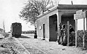
The Compagnie des chemins économiques de l'Est égyptien ( about the East Egyptian Railway Company ) built and operated a 350 km long network of ten narrow-gauge railway lines with a gauge of 1000 mm around Damanhour and Tanta in Egypt .

history

The Compagnie des chemins économiques de l'Est égyptien was founded on May 19, 1897 by the Belgian baron Édouard Empain (* 1852, † 1929) as a stock corporation. The French commercial bank Paribas was also involved in the establishment. Although it was not one of the actual founders, it replaced a group of German investors who had linked up with three local banks at other railway companies. The concession was granted to the Suarès , Menasce , Cattaui and Pelizaeus banks . They divided the fully paid-up capital of 200,000 pounds (5,040,000 francs ) into the following proportions: 55, 20, 15 and 10%.

The Egyptian state granted the concession for 70 years, after which it should become the owner without compensation at the end of the term. He guaranteed investors a net annual income of F 900 F / km; half of the gross receipts over F 5,625 per year per kilometer should belong to the government. Bank Paribas subscribed for a quarter of the capital, which was proportionally distributed among the founders, and elected a board member.

When it was founded, the company issued 12,500 shares each representing 3.5% of total assets, i.e. H. every 20 GBP (504 F ) redeemable in 70 years. Bank Paribas bought shares to the value of F 446.25 and sold them to the public at the same price with a 4% commission. The stocks and bonds were admitted to official listing. From a political point of view, the titles were one of the best concessions in Lower Egypt and encouraged French influence over Egypt. The annual net income guaranteed by the government of F 315,000 for the 350 km promised a comfortable profit margin compared to the total value of the shares of F 242,304. The investment exceeded the founders' most optimistic forecasts, which in March 1900 justified a capital increase to F8,125,000. The new shares at F 100 were issued for F 106.25, resulting in F 3,320,300. A quarter of the first and second tranches of the shares, and all bonds, were sold in France for a total of F 7,674,141.

In April 1900, the company was through the exchange of shares with the Egyptian Delta Light Railways Company combined . Paribas got off this train and had no connection with the Egyptian Delta Light Railways.

Individual evidence

  1. Jim Fergusson: List of train stations. (PDF) railwaystationlists.co.uk, accessed October 23, 2017 .
  2. a b c d e f g Samir Saul: La France et l'Égypte de 1882 à 1914: Intérêts économiques et implications politiques. Institut de la gestion publique et du développement économique, 2013, ISBN 978-2-8218-2862-9 , p. 318 ff.

Coordinates: 31 ° 2 ′ 3.3 ″  N , 30 ° 28 ′ 6.6 ″  E