Wedge Tomb from Coom
The Wedge tomb of Coom (also Labbydermot , Irish Leaba Dhiarmada , ( German "Bed Dermots" ), often simply called Coom Tomb ) is located in the townland of Coom ( Irish An Com ) (Bar. Uíbh Ráthach) on a slope, about 3.3 km northwest of Ballinskelligs in County Kerry in Ireland a few dozen meters east of the upper reaches of the Ballinskelligs River called creek, which drains into the bay of the same name. Wedge tombs ( German "Keilgräber" , formerly also called "wedge-shaped gallery grave") are double-walled, aisle-free, mostly undivided megalithic buildings from the late Neolithic and early Bronze Age .
description
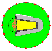
Excavations from 1966/67 show the presence of an enclosing trapezoidal cairns (stone mound) that was twelve meters long and ten meters wide in the southwest and narrowed to two meters in the northeast. Today the hill is largely leveled, further overgrown by the marshland and the peat formation ; to the south remains are still visible. Flint finds, processed several times, were found here, but no detectable burial remains in the area of the chambers.
The megalithic complex made of platy material is around five meters long and 1.5 meters wide at the front. There are 11 side bearing stones of the chamber, including the antechamber, and a capstone about three meters long and 1.5 m wide, which has been relocated but originally covered the entire chamber. The antechamber is unusually long and makes up about 40% of the system. There is a single end stone and two stones on the entry side of the chamber, which has a long and short support stone on each long side. The antechamber has three stones on each side that are approximately 1.5 m high. The facility is clearly visible and oriented south-west-north-east.
- Coom
The main chamber is 2.85 m long and tapers from an entrance width of 1.45 m in the southwest to 0.4 m in the northeast. The closing stone of the chamber is now a few centimeters east of the capstone. A blocking stone divides the portico (antechamber) from the main chamber. The approximately 3.2 m long Dachstein lies on the side stones in an easterly inclined position.
Surroundings
About 200 m north, in the Leabaleaha district, there is a menhir and a boulder burial . The approximately three meter high, pointed stone is 0.35 m thick and 1.0 m wide at the base. The boulder stone measures around 2.0 m × 1.5 m and is 0.4 m thick. It has several bowls on its surface.
About 500 m to the west is a stone mound about four meters in diameter. Nine stones lie on two circular arc segments in the south and northeast. The tallest stones are about a meter high.
See also
literature
- Elizabeth Shee Twohig: Irish Megalithic tombs. Princes Risborough Buckinghamshire 1990, ISBN 0-7478-0094-4 .
- Jürgen E. Walkowitz: The megalithic syndrome. European cult sites of the Stone Age (= contributions to the prehistory and early history of Central Europe. Vol. 36). Beier & Beran, Langenweißbach 2003, ISBN 3-930036-70-3 .
- Ruaidhrí de Valera, Seán Ó Nualláin: Survey of the Megalithic Tombs of Ireland, Volume IV, Counties Cork, Kerry, Limerick, Tipperary , Dublin 1982.
- A. O'Sullivan, J. Sheehan (both eds.): The Iveragh peninsula: an archaeological survey of South Kerry (South West Kerry Archaeological Survey), Cork University Press, 1996 (Reprint 2007), ISBN 978-0-90256- 184-7 . No. 76
Individual evidence
- ↑ a b Dataset: KE097-021 of the Irish National Monument Server in the Archaeological Survey of Ireland ; accessed on September 1, 2017
Web links
Coordinates: 51 ° 49 ′ 24.7 " N , 10 ° 18 ′ 48.9" W.


