Corps des guides


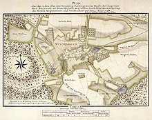
The Corps des Guides was a special unit of officers in the Duchy and later Kingdom of Württemberg . It mapped the theaters of war in times of war and offices and corridors of Württemberg in times of peace.
History and tasks
The beginning of the Corps des Guides is to be found in the autumn of 1759. At that time, the Württemberg troops set out from Ludwigsburg for the Fulda area in the Seven Years' War . Shortly before the march, a corps of guides consisting of three conductors and nine guides was set up. The corps had the task of probing the area and finding ways. It is assumed that this task led to the first measurements and mapping.
It is unclear from whom the initiative came to use the corps for civil surveying tasks. Possibly it was Quartermaster General Ferdinand Friedrich Nicolai , under whose direction this work began.
With the groundbreaking work of Johann Gottlieb Friedrich von Bohnenberger , the management of surveying was passed on to the Tübingen scholar, who in 1818 finally set the large, new Württemberg state surveying in motion.
Mapping space
Spatially, the focus of the corps work was in the northern and eastern offices of the Duchy of Württemberg and the Black Forest . Presumably, a set of maps showing the entire duchy was planned.
Map legend
On the maps, waters are turquoise green, roads brown, settlements and buildings red, the terrain brown or green depending on the type of crop. A distinction is made between fields, meadows, desert fields, gardens, vineyards and forests with the types of crops. The well-balanced labeling includes place and water body names as well as the more important field names and, depending on the need, the designation of special details.
Web links
supporting documents
- ^ Landesarchiv Baden-Württemberg, 365 days Baden-Württemberg, Belser Verlag, 2011, March 13th