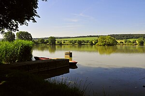
Cumbach ponds
| Cumbach ponds | ||
|---|---|---|

|
||
| Cumbacher pond from the top of the dam | ||
| Geographical location | District of Gotha | |
| Drain | Cumbach | |
| Location close to the shore | Friedrichroda | |
| Data | ||
| Coordinates | 50 ° 52 '29 " N , 10 ° 36' 25" E | |
|
|
||
| Altitude above sea level | 337.4 m | |
| surface | 26 ha | |
| length | 400 m | |
| width | 400 m | |
| scope | 3.2 km | |
The Cumbacher Teiche are shallow, nutrient-rich fish ponds near Cumbach , a district of the town of Friedrichroda in the Gotha district in Thuringia.
The Cumbach ponds are fed by two streams: one is the stream of the same name, whose source is in the Rödicher pond northeast of Rödichen and which initially feeds the small driving pond before it flows into the upper Cumbach pond. The other stream is a trickle, coming from Rödichen, which, after flowing through two small ponds, feeds the Igelsbach . From there a stream also goes into the upper Cumbacher pond. The outflow of the Cumbach from the lower Cumbacher pond flows into the Hörsel after about 1.8 km east of the locality of Cumbach .
The Old Cumbacher pond , already should, the local tradition High Middle Ages by the monks of the neighboring monastery Reinhardsbrunn have been created to carp and other fish to multiply as fast food. Its name at that time was Espenfelder Teich , it had a size of 39 hectares. At Igelsteich was a court of the Reinhardsbrunn Monastery, where around 1530 members of the Anabaptist community of Zella St. Blasii were executed with the sword. An entry with the field name “On the court” in a map of the Ernstroda municipality from 1933 indicates this place of jurisdiction.
The New Cumbacher Pond was only created in the 1970s when the meadows above the old pond were separated from agricultural use.
The ponds have the following dimensions:
| surface | scope | |
|---|---|---|
| Hedgehog pond | 13,000 m² | 530 m |
| Driving pond | 3,945 m² | 278 m |
| Upper Cumbacher pond | 105,350 m² | 1,178 m |
| Lower Cumbacher pond | 118,557 m² | 1,289 m |
The ponds mentioned have a total area of just over 24 hectares and are managed by the Reinhardsbrunn fishing cooperative. The area is company premises, there is a year-round bathing ban. A former farm building on the top of the dam once served as accommodation for the workers; it is now in a ruinous condition.
The use as a fish pond also allows the preservation of numerous amphibian species that mate in the pond area. The Cumbach ponds are the most important spawning grounds for amphibians and crested newts in Thuringia. Although only a few public roads are used around the ponds, up to 16,000 individuals have to be rescued each year from death by volunteers at the prepared collection and collection points.
See also
Web links
Individual evidence
- ↑ Official topographic maps of Thuringia 1: 10,000. District of Gotha, Wartburg district, district-free city of Eisenach . In: Thuringian Land Survey Office (Hrsg.): CD-ROM series Top10 . CD 2. Erfurt 1999.
- ↑ The Anabaptists in the Contradictions of Time , brochure of the "Thuringian Information Center", ISBN 978-3-946031-02-4
- ↑ Ronald Bellstedt : Ponds between Ohra and Hörsel. Part 3. Cumbacher Teiche In: Hörselbergbote, Heft 84, Wutha-Farnroda 2011 pp. 22–26

