
Cuyo Archipelago
| Cuyo Archipelago | ||
|---|---|---|
 |
||
| Waters | Sulu Lake | |
| archipelago | Philippines | |
| Geographical location | 10 ° 51 ′ N , 121 ° 2 ′ E | |
|
||
| Number of islands | 45 | |
| Main island | Cuyo Island | |
| Total land area | 171.78 km² | |
| Residents | 41,807 (2007) | |

The Cuyo Archipelago is a group of islands in the Philippines . The group of over 45 islands is located east of the island of Palawan in the northern Sulu Sea . The island group divides the Sulu Sea in this sea area into the Cuyo East and Cuyo West Passages, both of which are important sea routes for shipping from Southeast Asia to the People's Republic of China , Taiwan and Japan . The entire archipelago belongs to the MIMAROPA administrative region . Three municipalities were set up to manage the archipelago: Cuyo , Agutaya and Magsaysay , all of which belong to the province of Palawan.
The archipelago is divided into the northern Quiniluban group and the southern Cuyo Islands. The largest island of the archipelago is Cuyo Island, on it is the highest point of the island group of Mount Bombon. It rises about 77 meters above sea level and is an inactive volcano . Other well-known islands of the archipelago are Manamoc , Agutaya, Carnasa-, Pamilican-, Tinituan-, Halog-, Did-, Taytay and Oco Island.
The Cuyo Archipelago was only colonized by the Spanish in the middle of the 17th century, the Cuyo Fort, completed in 1683, dates from this time . It served to control the trade routes and to protect against the Moro pirates.
There are numerous coral reefs and sea grass meadows in the island archipelago . The vegetation consists of dense tropical vegetation on the larger islands. Larger colonies of white- nest salangans ( Aerodramus fuciphagus ) nest on some islands .
The islands can be reached via the ports of northern Palawan and the west coast of Panay . The transport is handled by larger local outrigger boats. The crossing from North Palawan and Panay takes about 12 to 15 hours, depending on the weather and destination.
gallery
Quiniluban group

Manamoc Island

Pamalican island.

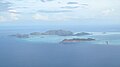
Agutaya Island and the narrow Oco Island in the foreground


Individual evidence
- ↑ Statistical information from the NSCB ( Memento of the original from February 29, 2012 in the Internet Archive ) Info: The archive link was inserted automatically and has not yet been checked. Please check the original and archive link according to the instructions and then remove this notice.
- ^ The Philippine Island World
- ↑ Best Philippine Islands ( Memento of the original from May 12, 2012 in the Internet Archive ) Info: The archive link was inserted automatically and has not yet been checked. Please check the original and archive link according to the instructions and then remove this notice.
- ↑ Information about the Cuyo Fort ( page no longer available , search in web archives ) Info: The link was automatically marked as defective. Please check the link according to the instructions and then remove this notice. (English)