Cuyo (Palawan)
| Municipality of Cuyo | ||
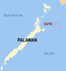
| Location of Cuyo in the province of Palawan | ||
|---|---|---|

|
||
| Basic data | ||
| Region : | Western Visayas | |
| Province : | Palawan | |
| Barangays : | 17th | |
| District: | 1. District of Palawan | |
| PSGC : | 175310000 | |
| Income class : | 4. Income bracket | |
| Households : | 3609 May 1, 2000 census
|
|
| Population : | 22,360 August 1, 2015 census
|
|
| Coordinates : | 10 ° 51 ' N , 121 ° 1' E | |
| Postal code : | 5318 | |
| Geographical location in the Philippines | ||
|
|
||
Cuyo is a municipality in the Philippines in the province of Palawan . It has 22,360 inhabitants (August 1, 2015 census). It is located on the main island of the Cuyo Archipelago . In the Spanish colonial era, the Cuyo Fort was built on Capusan Beach / Gapusan Beach in 1683.
There is a Palawan State University campus in the community .
Barangays
Cuyo is politically divided into 17 barangays .
|
|
|
