
Dýrafjörður
| Dýrafjörður | ||
|---|---|---|
 The Dýrafjörður inland. |
||
| Waters | Atlantic Ocean | |
| Land mass | Iceland | |
| Geographical location | 65 ° 50 ′ N , 23 ° 11 ′ W | |
|
||
| width | 9 km | |
| depth | 32 km | |
| Tributaries | Botnsá | |

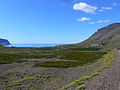
The Dýrafjörður is a fjord in the Icelandic region of Vestfirðir (Westfjords).
It is located north of Arnarfjörður and south of Önundarfjörður . The Dýrafjörður is about 9 km wide and 32 km inland. On the southern bank is the place Þingeyri . One of the four land collectors in this fjord was Dýri von Sunnmæri, after whom the fjord was named.
The Núpur farm on the north bank is of historical importance. It was the ancestral seat of one of the most powerful families of chiefs in Iceland in the Middle Ages, the Núpverjar. Nothing is left of the court. In its place there is now a hotel.
Vestfjarðavegur ran around half the eastern part of the fjord ![]() . In 1990 a 120 m long bridge and a dam were completed, which shorten the circumference of the inner fjord. In this area, the Dýrafjarðargöng tunnel is to be built as a safe connection to Arnarfjörður.
. In 1990 a 120 m long bridge and a dam were completed, which shorten the circumference of the inner fjord. In this area, the Dýrafjarðargöng tunnel is to be built as a safe connection to Arnarfjörður.

The place Þingeyri on Dýrafjörður.

Þingeyri

Mýrar on the north bank. The place was already settled around 1200.
View of the fjord exit. In the background the former chief's seat Núpur.
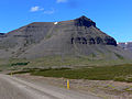
A mighty mountain of the same name rises above Nupur.

Overview of the Westfjords.


_2.jpg)

.JPG)

See also
Individual evidence
- ↑ Brúaskrá - Brýr á þjóðvegum (February 2016). Retrieved August 11, 2018 (Icelandic).