Dahlak Kebir
| Dahlak Kebir | ||
|---|---|---|
| Waters | Red Sea | |
| Archipelago | Dahlak Archipelago | |
| Geographical location | 15 ° 40 ′ N , 40 ° 7 ′ E | |
|
|
||
| length | 62 km | |
| width | 27 km | |
| surface | 662.62 km² | |
| Highest elevation | At 49 m |
|
| Residents | 1955 3 inhabitants / km² |
|
| main place | Jīmhīl | |
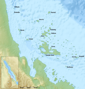
| Daklak Kebir in the Dahlak Archipelago | ||
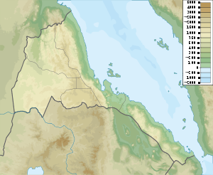
Dahlak Kebir is the largest island in the Dahlak archipelago , which is part of Eritrea .
geography
The island in the Red Sea was originally called Dahlak Deset . The island is 62 km long and up to 27 km wide and has an area of 662.62 km². The maximum height of the island is indicated on maps as 49 meters to 54 meters. The approximately 2000 Dahalik- speaking residents make their living from fishing, sea cucumber farming and tourism .
The main town is the village of the same name Dahlak Kebir on a small bay on the southwest coast. The small bay is also known by its English name Paradise Bay .
There are a total of eleven villages on Dahlak Kebir (with estimated population figures):
![]() Map with all coordinates: OSM | WikiMap
Map with all coordinates: OSM | WikiMap
| Surname | Residents | Coordinates | comment |
|---|---|---|---|
| Dahlak Kebir | 300 | 15 ° 36 ′ 55 ″ N , 40 ° 0 ′ 18 ″ E | Historic capital of the archipelago |
| Harpsichord (Gembali, Jīmhīl) | 300 | 15 ° 45 ′ 36 ″ N , 39 ° 57 ′ 5 ″ E | Capital of the Dahlak region, residence of the Sheikh, with a clinic |
| Derbushat (Durubbishet) | 250 | 15 ° 40 ′ 11 " N , 40 ° 7 ′ 13" E | in the center of the island, with clinic, mosque, 8–10 fountains |
| Melill | 200 | 15 ° 45 ′ 59 " N , 39 ° 58 ′ 45" E | typical fishing village |
| Salad (Sal'et) | 200 | ... | |
| Dhu Bellu (Dub'ullu, Debe'āluwa) | 180 | 15 ° 44 ′ 34 " N , 40 ° 7 ′ 6" E | with historical sites |
| Dasuco (Dasqo) | 170 | ... | |
| Memla | 125 | 15 ° 37 ′ 42 " N , 40 ° 24 ′ 9" E | |
| Kubbani | 100 | 15 ° 50 ′ 15 " N , 40 ° 5 ′ 23" E | |
| Kumbeiba (Cumbeiba) | 90 | 15 ° 48 ′ 37 " N , 39 ° 59 ′ 44" E | |
| Soguri | 40 | ... |
The sum of the aforementioned population of the eleven villages results in 1955 for the entire island.
The village of Dahlak Kebir is known for its early medieval cistern or necropolis . There are also many fossils on the island , the remains of pre-Islamic cultures in the nobility and mangrove swamps .
There are ferry connections to Massaua and other islands of the Dahlak archipelago.
Individual evidence
- ↑ Tactical Pilotage Chart TPC K-5B : 161 feet
- ↑ Soviet General Staff Map 1: 200,000 , map sheet D37-05
- ^ MM Asfour: The Ports and Trade of the Red Sea Basin , Durham 1963, p. 44
- ↑ Mussie Gebreyohanns: The State of Tourism in Eritrea: Tourism Development in the Dahlak Islands , page 84
- ↑ Mussie Gebreyohanns: The State of Tourism in Eritrea: Tourism Development in the Dahlak Islands , page 88
- ↑ The modern capital of the Dahlak region, Jimhil, is not a variant of Dasqo (Dasuco), as Simeone-Senelle (2005) writes. Marie-Claude SIMEONE-Senelle: Up-to-date assessment of the results of the research on the language Dahalik language (2005) are in registered version for Dasqo Jimhile to

