Daubornring
|
Address: |
|
|
|
|
||
| Route type: | permanent autocross track | |
|---|---|---|
| Owner: | Municipality of Hünstelden | |
| Operator: | Auto-Cross-Team Dauborn eV | |
| Opening: | 1979 | |
| Track layout | ||
| Route data | ||
| Route length: | 0.46 km (0.29 mi ) | |
| Curves: | 3 | |
| Curve superelevation: | Yes | |
| act-dauborn.de | ||
Coordinates: 50 ° 19 ′ 50 ″ N , 8 ° 12 ′ 19 ″ E
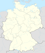
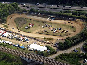
The Daubornring is a 460 meter long autocross track built in 1979 in the municipality of Hünstelden im Taunus .
Runs for the German Autocross Championship of the German Rallye-Cross Association take place on the Daubornring. Contrary to the association's ambiguous naming, this is not a rallycross race. The autocross area is located between Dauborn (municipality of Hünstelden) and Niederselters (municipality of Selters ). It is bounded by the ICE route Frankfurt – Cologne and the parallel A3 motorway . The race track is operated by the Auto-Cross-Team Dauborn eV
The Daubornring is located on the K 507 state road between the towns of Hünstelden Dauborn and Selters.
The top special cross vehicles need less than 19 seconds for one lap on this route and thus reach an average speed of over 80 km / h. The top speed on the back straight is 120 km / h. One attraction are the floodlit twilight / night races on Saturday evenings .
As in a stadium arena, the route is fully visible to spectators. The Daubornring is driven counter-clockwise. The long, steep curve after the start and finish straight is a special feature of the route.
Web links
- act-dauborn.de , homepage of the operating club
Individual evidence
- ↑ The Daubornring at Freizeit Mittelhessen

