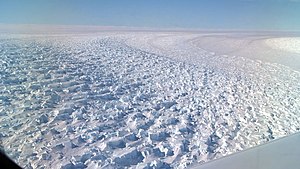
Denman glacier
| Denman glacier | ||
|---|---|---|
| location | Queen Marie Land , East Antarctica | |
| length | 112 km | |
| width | Max. 16 km | |
| Coordinates | 66 ° 45 ′ S , 99 ° 30 ′ E | |
|
|
||
| drainage | Shackleton Ice Shelf | |
The Denman Glacier is an approximately 11 to 17 km wide glacier in the East Antarctic Queen Marie Land , which flows into the Shackleton Ice Shelf east of David Island after a flow distance of 112 km .
Members of the Australasian Antarctic Expedition (1911-1914) under the direction of the Australian polar explorer Douglas Mawson discovered him in November 1912. Mawson named him after Thomas Denman, 3rd Baron Denman (1874-1954), the then Governor General of Australia and patron of the expedition.
The ice mass of the glacier corresponds to about 1.5 m rise in sea level. The glacier tongue extends into the Shackleton Ice Shelf and, in the mid-2010s, covered an area of around 24,000 km².
Accurate mapping of the relief on the floor of the Antarctic Ice Sheet in the years prior to 2019 showed that the lowest point on the surface of the continental crust is located under the Denman Glacier . Beneath the glacier is Denman Canyon , a canyon that reaches a depth of 3500 m below sea level . Until this discovery, the Bentley subglacial ditch held this record at 2,496 m below sea level .
The glacier lost around 270 Gt of ice mass between 1979 and 2017. Satellite-based interferometry measurements show that the glacier's touchdown line decreased by 5.4 km inland between 1996 and 2017/2018. The eastern flank of the touchdown line is now stabilized by an underwater ridge . In the western part, the decline continues along a submarine gully that is 1,800 m below sea level and deepens to the Denman Canyon. With the tides, warm water is likely to penetrate below the glacier's touchdown area and melt it from below. If the process continues and warm circumpolar deep water penetrates the area below the glacier, the Denman Glacier could retreat rapidly.
Icebergs calving from the glacier form the Pobeda in an underwater shoal .
Web links
- Denman Glacier in the Geographic Names Information System of the United States Geological Survey (English)
- Denman Glacier on geographic.org (English)
Individual evidence
- ↑ Denman Glacier ( English ) In: Geographic Names Information System . United States Geological Survey . Retrieved December 12, 2019.
- ↑ a b V. Brancato, E. Rignot, P. Milillo, M. Morlighem, J. Mouginot, L. An, B. Scheuchl, S. Jeong, P. Rizzoli, JL Bueso Bello, P. Prats ‐ Iraola: Grounding line retreat of Denman Glacier, East Antarctica, measured with COSMO ‐ SkyMed radar interferometry data . In: Geophysical Research Letters . March 23, 2020, doi : 10.1029 / 2019GL086291 (open access).
- ↑ Mathieu Morlighem, Eric Rignot, Tobias binder and 34 other authors: Deep glacial troughs and ridges stabilizing unveiled beneath the margins of the Antarctic ice sheet . In: Nature Geoscience . December 12, 2019, doi : 10.1038 / s41561-019-0510-8 (English).


