East Belfast
East Belfast ( Irish Béal Feirste Thoir ) is a district of Belfast to the east of the city center , which is spatially separated by the Lagan . The district, which forms one of four Belfast constituencies and was represented by Peter Robinson ( DUP ) in the British Parliament from 1979 to 2010 , has 79,621 inhabitants (2001). In 2010 the non-denominational and liberal Alliance Party of Northern Ireland was able to win its first mandate in the House of Commons with Naomi Long , which was lost to the DUP in 2015.
A large number of construction projects have been tackled in recent years, especially along the waterfront , and some have already been completed: For example the Odyssey Center , which includes an arena for ice hockey and concerts, an IMAX cinema and an interactive museum.
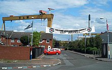
The scenery of East Belfast is dominated by the two cranes from Harland & Wolff shipyard , popularly known as Samson and Goliath , which are considered to be the tallest free-standing cranes in the world. Starting from the shipyard, there are extensive industrial areas along Belfast Lough and the extension of the M3 motorway ( Sydenham By-Pass ) towards Bangor . Belfast City Airport is also nearby .
To the south of the motorway and the railway line connecting Belfast with Bangor is The Oval stadium of Belfast football club Glentoran FC .
East Belfast is predominantly inhabited by Protestants, around 85% of the population of East Belfast count towards this part of the population, compared to just under 10% on the Catholic side. This superiority is particularly noticeable through murals ( Murals ) along the Newtownards Road - the main artery East Belfast - noticeable, the west end of the dismal acting block of flats settlement Ballymacarrett is embossed. But Protestants also make up the majority in the communities of Dundonald and Castlereagh (both in County Down ), which border to the east and south-east . The Connswater Shopping Center is considered the center of East Belfast .
Directly adjacent to the Lagan is Short Strand , an enclave located south of Newtownards Road and almost exclusively inhabited by Catholics, which in the past was often the focus of clashes between the two rival population groups.
Stormont Castle , located in a large park in the Belmont district , at the eastern end of Newtownards Road, is well worth a visit . This is where the Northern Irish Regional Government and the Northern Irish Assembly are located .
Web links
Coordinates: 54 ° 36 ′ N , 5 ° 53 ′ W

