
Echizen Kaga Kaigan Quasi National Park
|
Echizen Kaga Kaigan Quasi National Park
|
||
 Hokoshima |
||
| location | Ishikawa Prefecture and Fukui Prefecture , Japan | |
| surface | 92.46 km² | |
| WDPA ID | 3253 | |
| Geographical location | 36 ° 15 ' N , 136 ° 12' E | |
|
||
| Setup date | May 1, 1968 | |
| administration | Ishikawa Prefecture and Fukui Prefecture | |

The Echizen-Kaga-Kaigan Quasi-National Park ( Japanese 越 前 加 賀 海岸 国 定 公園 , Echizen kagakaigan kokutei kōen ) is one of over 50 quasi-national parks in Japan. Ishikawa and Fukui prefectures are responsible for managing the park. The park was founded on May 1st, 1968 and covers an area of approx. 90 km². With the IUCN Category V, the park area is classified as a Protected Landscape / Protected Marine Area . The park area consists of several non-contiguous coastal areas.
Striking places in the park:
- Cliff Tōjinbō ( 東 尋 坊 ), or Tōjimbō
- Oshima Island ( 雄 島 ): Consists of andesite lava and is surrounded by sharp and steep cliffs
- Echizen Matsushima Island ( 越 前 松 島 )
- Kochōmon ( 呼 鳥 門 ): Natural stone arch, approx. 15 m high
- Echizen daffodil fields ( 越 前 水仙 , Echizen suisen ): On the steep slope of the coastline of around 20 km
- Nakaikemi Wetland ( 中 池 見 湿 地 , Nakaikemi shitchi ): Many rare species of wildlife that have been preserved by growing rice
The cliff of Tōjinbō Oike, which is 25 m above sea level and is therefore one of the largest in the world, is particularly well-known.
gallery

Tōjinbō ( 東 尋 坊 ) cliff
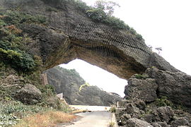
Kochōmon ( 呼 鳥 門 )
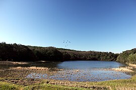
Pond ("ike") Katano Kamo

Mizuaoi in the Nakaikemi wetland
_08_Jun,_2013_-_panoramio.jpg)


See also
Web links
- World Database on Protected Areas - Echizen-Kaga-Kaigan-Quasi-National Park (English)
- Information from the Japanese Ministry of the Environment on changes in the quasi-national park (Japanese, PDF)
Individual evidence
- ↑ Information from Fukui Prefecture on the quasi-national park . 福井 県 Fukuiken ( Fukui Prefecture ), November 16, 2018, accessed on December 24, 2019 (jp).