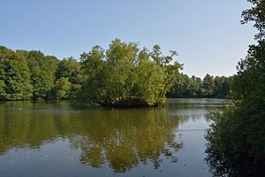
Edendorfer clay pit
| Edendorfer clay pit | ||
|---|---|---|

|
||
| The clay pit in July 2013 | ||
| Geographical location | Steinburg district , Schleswig-Holstein , Germany | |
| Tributaries | Sieversbek | |
| Drain | Sieversbek | |
| Places on the shore | Itzehoe | |
| Data | ||
| Coordinates | 53 ° 56 '51 " N , 9 ° 29' 48" E | |
|
|
||
| surface | approx. 3.2 ha | |
The Edendorfer Tonkuhle in Itzehoer district Edendorf is a Tagebaurestsee . Since there are several clay pits in Edendorf, it is also called the large Edendorfer clay pit to distinguish it from the smaller ones.
After the removal of clay the late 19th and early 20th century, the pit filled with water and was subsequently prepared as a green area. Today the water is also used as fishing water by the SAV Itzehoe.
literature
- Eike von Hacht: Chimneys over Edendorf - A farming village becomes an industrial location . In: Heimatverband Kreis Steinburg (ed.): Steinburger Jahrbuch 2009 , Itzehoe 2008, pp. 69–74.
Individual evidence
Web links
Commons : Edendorfer Tonkuhle - Collection of images, videos and audio files
