
Sieversbek
|
Sieversbek Sieversbach |
||
 The Sieversbek shortly before crossing under the A 23 |
||
| Data | ||
| location | Schleswig-Holstein , Germany | |
| River system | Elbe | |
| Drain over | Moor weather → Stör → Elbe → North Sea | |
| source | Itzehoe-Edendorf 53 ° 56 '58 " N , 9 ° 29' 58" E |
|
| muzzle | In Heiligenstedten over the moor weather in the Stör
|
|
The Sieversbek or Sieversbach is an (indirect) right tributary of the sturgeon in Itzehoe and Heiligenstedten .
The Sieversbek begins south of the former center of the Edendorf district of Itzehoe, northeast of the (large) Edendorfer Tonkuhle . It flows through this and leaves it piped towards the southwest. On the Sieversbek street named after him, it is dammed up to form a chain of ponds; Below the road it flows through another rain retention basin and then flows along the Sieversbek development area to the south-south-west. He then leaves the area of the city of Itzehoe under the federal highway 23 towards the west-south-west. In Heiligenstedten he led until the mid 20th century, almost at the northernmost point of the Störknies about the Stately Siel in the sturgeon. In the late 1950s was to relieve the east-west trench to Moor bettors created, from which the water flows through a pumping station in the sturgeon. Since the amount of water flowing off over the manorial sluice was only small, the sluice silted up on the disturbing side, so that the Sieversbek now only flows off over the east-west ditch and the moor weather.

The Sieversbek flows through the drained pond on the Sieversbek road

Connector on the B 5

The east-west ditch seen from the Juliankadamm from the west
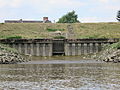
The stately Siel silted up at low tide

Stately sluice and sturgeon seen from the dike


