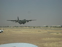
Abéché airport
| Abéché airport | |
|---|---|

|
|
| Characteristics | |
| ICAO code | FTTC |
| IATA code | AEH |
| Coordinates | |
| Height above MSL | 545 m (1788 ft ) |
| Transport links | |
| Distance from the city center | 2 km north of Abéché , Chad |
| Local transport | taxi |
| Start-and runway | |
| 09/27 | 2800 m × 30 m asphalt |
The Abeche Airport ( IATA : AEH , ICAO : FTTC ) is the airport 's fourth largest city of Chad , Abéché . It is located two kilometers north-northeast of the city on the outskirts.
General
The airport is at an altitude of 545 m above sea level . It has an asphalt runway (09/27) with a length of 2800 meters, so that larger commercial aircraft could land at the airport .
Airlines and Destinations
The airport is currently no longer served by scheduled flights. Toumaï Air Tchad recently flew to N'Djamena .
incident
On June 11, 2006 a Lockheed C-130 ( aircraft registration TT-PAF ) of the Chad Air Force, coming from N'Djamena, crashed while approaching the airport. All five people on board were killed.
Web links
- List of airports in Chad
- Abéché Airport aeronautical map on SkyVector.com
Individual evidence
- ↑ a b c d 14 AD 2-5 Abeche (FTTC) - Caractéristiques. (PDF; 75.4 kB) In: AIP TCHAD. Agence pour la Sécurité de la Navigation Aérienne en Afrique et à Madagascar (ASECNA), August 20, 2015, archived from the original on March 4, 2016 ; accessed on September 11, 2017 (French; English).
- ^ AEH - Abéché, OD, TD - Airport - Great Circle Mapper. Retrieved September 9, 2017 .
- ↑ Toumai Air Tchad on ch-aviation. Retrieved September 9, 2017 (American English).
- ^ Accident report C-130 TT-PAF , Aviation Safety Network (English), accessed on September 9, 2017.