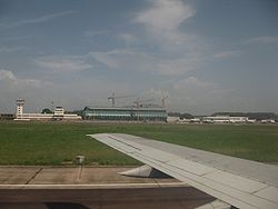
Brazzaville Maya-Maya Airport
| Aeróport de Brazzaville Maya-Maya | |
|---|---|

|
|
| Characteristics | |
| ICAO code | FCBB |
| IATA code | BZV |
| Coordinates | |
| Height above MSL | 319 m (1047 ft ) |
| Transport links | |
| Distance from the city center | 3 km northwest of Brazzaville |
| Basic data | |
| operator | ASECNA - Aéroport de BRAZZAVILLE |
| Passengers | 985,598 (2016) |
| Air freight | 12,042 t (2016) |
| Runways | |
| 05L / 23R | 3300 m × 45 m asphalt |
| 05R / 23L (out of order, only used as a taxi route) | 3300 m × 45 m asphalt |
The Aéroport de Brazzaville Maya Maya is the international airport of Brazzaville in the Republic of Congo . Internationally, the airport is served by Europe from Paris, among others. The airline ECAir was headquartered at Brazzaville Airport.
Incidents
- On November 30, 2012, an Ilyushin Il-76T of the Aero-Service crashed while approaching the airport. In doing so, she destroyed several houses. All six crew members and 19 people on the ground were killed and 14 injured.
Web links
Commons : Maya-Maya Airport - Collection of pictures, videos and audio files
Individual evidence
- ↑ a b Brazzaville Airport Key Information. Egis-Airports-Network.com , accessed on March 27, 2018 (English).
- ↑ AIP Congo 5 AD 2-1 FCBB, May 1, 2014
- ↑ Noatem Brazza Sommaire from September 6, 2012 (English, accessed on May 7, 2015) ( Memento of the original from September 16, 2012 in the Internet Archive ) Info: The archive link was automatically inserted and not yet checked. Please check the original and archive link according to the instructions and then remove this notice.
- ↑ AV-Herald "Crash: Aero Services IL76 at Brazzaville on Nov 30th 2012, impacted buildings short of runway" (English, accessed on May 7, 2015)