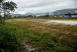
Telupid airport
| Telupid Airport Lapangan Terbang Telupid |
|
|---|---|

|
|
| Characteristics | |
| ICAO code | WBKE |
| IATA code | TEL |
| Coordinates | |
| Height above MSL | 105 m (344 ft )
|
The telupid Airport (engl. Telupid Airport , IATA code : TEL, ICAO code : WBKE) is a former airfield in telupid in the Malaysian state of Sabah on the island of Borneo , which ceased its operation 1,983th
The airport was a civil domestic airport for light aircraft that was only approved for operation in daylight. The runway consisted of a grass runway. The former runway runs parallel to the Telupid-Ranau road at the level of the SMK Telupid secondary school . Nothing is left of the former airfield facilities, only the runway can be located on the basis of the compacted and absolutely flat surface. At the end of the slope there is a larger, white-strewn space, which probably served as a parking or turning position.
Individual evidence
- ^ Oleh 'Deep Throat' Sabah ; Accessed March 5, 2013
- ↑ Pilot information for Telupid Airport ; Accessed March 5, 2013
- ↑ Airport data on Great Circle Mapper
- ↑ On-site exploration by the author on February 9, 2013.
Web links
Commons : Airfield Telupid - Collection of Images