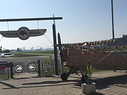
Triengen airfield
| Triengen airfield | |
|---|---|

|
|
| Characteristics | |
| ICAO code | LSPN |
| Coordinates | |
| Height above MSL | 486 m (1594 ft ) |
| Transport links | |
| Distance from the city center | 19 km south of Aarau , Switzerland |
| Street | Hauptstrasse 24 , Kantonsstrasse 51 |
| Basic data | |
| operator | Flying Ranch AG |
| Start-and runway | |
| 15/33 | 570 m × 15 m asphalt |
The airfield Triengen ( ICAO code LSPN ) is a private airfield in Triengen in Switzerland .
With a length of 395 m, the runway was the shortest paved runway in Switzerland. However, in October 2010 it was extended by 160 m towards the south. The airfield is located at an altitude of 486 m above sea level. M. south of Triengen. It is used by powered pilots and parachutists .
There is a restaurant and a children's playground at the airport.
history
Heinrich Müller, a farmer and innkeeper from Triengen who loves flying, founded the airfield in 1947. Initially, the aircraft were rented in Lucerne and were used to make sightseeing flights with relatives and friends. Take-off and landing were considered an attraction and people gathered on the airfield site. In 1948, the only hangar in existence at the time collapsed and an aircraft was buried under the rubble. In the following years a farm and a larger hangar were built on the airfield site.
In 1965 Triengen was considered a regular airport for the Lucerne and Aargau pilots. A year later, the grass runway was replaced by a hard surface runway. In 1969, Franz Müller founded the Flying Ranch Triengen flight school . Years of discussion regarding aircraft noise led to a referendum in 1994. It turned out that a large part of the population was behind the airfield and the Müller family. In 1994 another hangar with a workshop was built. In 1997 the airfield celebrated its 50th anniversary.
Web links
- Official website
- History on flyingranch.ch