Fresvikbreen
| Fresvikbreen | ||
|---|---|---|
|
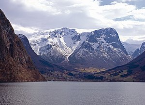
Fresvik with the Fresvikbreen in the background |
||
| location | Vik Municipality , Vestland , Norway | |
| length | 5 km | |
| surface | 15 km² | |
| Altitude range | 1642 moh. - 1250 moh. | |
| Coordinates | 61 ° 2 '7 " N , 6 ° 46' 22" E | |
|
|
||
| drainage | Helgedøla → Storelvi → Sognefjord | |
The Fresvikbreen is a glacier in Norway . It is located on the south side of the Sognefjord in the municipality of Vik and is part of the Nærøyfjorden World Heritage Park . With a size of around 15 km², it is the 23rd largest glacier on the Norwegian mainland. The highest point is 1642 meters above sea level.
At the edge of the glacier traces of guide fences, pitfalls and shooting ranges were found that were dated to the Iron Age and were used for reindeer hunting . The historic Jordalsvegen leads from Fresvik on the Sognefjord over two branches of the Fresvikbreen - Gryteskarvfonni and Langafonni to Jordalen in the municipality of Voss . In earlier times this path was mainly used by the farmers in Fresvik as an alpine path to reach their alpine huts in Øvstedalen . At the junction of the Jordalsvegen with the path to Dyrdal stands the stone man Fresvikvarden, which is said to come from the time before Svartedauden and was used as a sacrificial place in earlier times.

