Friedensbrücke (Weil am Rhein)
Coordinates: 47 ° 35 ′ 35 ″ N , 7 ° 36 ′ 27 ″ E
| Peace Bridge | ||
|---|---|---|
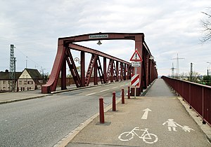
| Peace Bridge from the East (2012) | ||
| use | Street, pedestrians | |
| Convicted |
|
|
| Crossing of | Track system | |
| Subjugated |
|
|
| place | Because on the Rhine | |
| construction | Truss bridge | |
| overall length | 172 meters | |
| Longest span | 60 meters | |
| height | 260 m above sea level NHN | |
| completion | 1908 | |
| toll | no | |
| location | ||
|
|
||
The Friedensbrücke in the Baden-Württemberg town of Weil am Rhein connects the districts of Friedlingen and Leopoldshöhe . It leads the federal road 317 over the track surface of the train station below, north of the bridge, and underlies the federal road 3, which runs parallel to the railway line in this section . At the east end of the bridge is the shopping center shopping island .
history
The bridge was originally built in 1908 by the Deutsche Eisenbahn-Gesellschaft under the name Wilhelmsbrücke . Shortly before the end of the Second World War , the German Wehrmacht blew up the bridge. After the renovation, it was reopened for public transport on December 21, 1950. It also got its current name.
In July 2013, another bridge for the cross-border tramway (→ joint line with the SWEG ) between Weil am Rhein and Basel was built north and parallel to the Friedensbrücke . It was completed at the end of 2014, and since December 14, 2014, line 8 of the Basel tram line has been running over the track bed of regional and long-distance trains.
architecture
The bridge has three fields with a continuous truss and a curved upper chord. Their field widths are 50 meters, 50.5 meters and 60 meters. The riveted trusses are painted a dark red. While the east ramp from the hamlet city center leads straight to the bridge at ground level, the west ramp rises from the south from the lower Friedlingen and makes a 90-degree turn before it leads to the bridge. The name Friedensbrücke is painted on the cross member at the entrances on the west and east sides . A lantern hangs underneath . The motorized traffic is led through the steel structure, while there is an additional lane for pedestrians and cyclists on the outside. In the evening hours, these strips are illuminated by lanterns on the girder, which hang from arched girders on the side of the structure. On the south side, two stairs lead down to the railroad system of the freight yard, which are intended for the service personnel.
Web links
- City of Weil am Rhein: Friedensbrücke
Individual evidence
- ^ Paul Müller: We wanted to change the world ... Stations in the life of an old socialist , Athenaeum Verlag, 1990, ISBN 978-3-610-08459-2 , page 272.
- ↑ Badische Zeitung : City and Bahn agree on Trambrücke , article from July 4, 2012, accessed on September 3, 2013
- ^ Bridges in Weil am Rhein on the website of Karl Gotsch bridges database


