Friedrichshöhe (Wuppertal)
|
Friedrichshöhe
City of Wuppertal
Coordinates: 51 ° 14 ′ 13 ″ N , 7 ° 11 ′ 26 ″ E
|
||
|---|---|---|
| Height : | 342 m above sea level NHN | |
|
Location of Friedrichshöhe in Wuppertal |
||
|
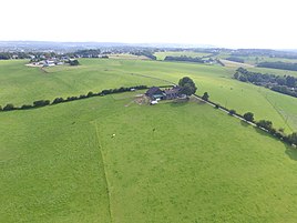
Friedrichshöhe top left, in front a Baur living space
|
||
Friedrichshöhe is a locality in the mountainous city of Wuppertal .
Location and description
The local situation is at 342 m above sea level. NHN south of Landesstraße 419 in the residential area Ronsdorf-Mitte / Nord in the Ronsdorf district .
Etymology and history
The name Friedrichshöhe is derived from the Friedrichs family, who owned agricultural land in the area.
The location arose in the second half of the 19th century. In the municipality lexicon for the province of Rhineland from 1888 a house with 15 inhabitants is given.
In the late Middle Ages and the early modern period, the Elberfeld line of the Bergische Landwehr ran through the area where it is today. A barrier in this Landwehr is notarized in the vicinity . To the north was the Jägerhof amusement park .
Individual evidence
- ^ Wolfgang Stock: Wuppertal street names. Their origin and meaning. Thales Verlag, Essen-Werden 2002, ISBN 3-88908-481-8
- ↑ Königliches Statistisches Bureau (Prussia) (Ed.): Community encyclopedia for the Rhineland Province, based on the materials of the census of December 1, 1885 and other official sources, (Community encyclopedia for the Kingdom of Prussia, Volume XII), Berlin 1888.

