
Furnas lake (Azores)
| Furnas lake | ||
|---|---|---|

|
||
| Lake Furnas from the Pico do Ferro viewpoint north of the lake. | ||
| Geographical location | District of Povoação , Sao Miguel , Azores , Portugal | |
| Drain | none | |
| Places on the shore | no | |
| Location close to the shore | Furnas | |
| Data | ||
| Coordinates | 37 ° 45 '30 " N , 25 ° 19' 58" W | |
|
||
| Altitude above sea level | 281 m | |
| surface | 1.93 km² | |
| length | 2.025 km | |
| width | 1.6 km | |
| volume | 13,317,000 m³ | |
| Maximum depth | 15 m | |
| Middle deep | 6.9 m | |

|
||

The Furnas Lake ( Portuguese: Lagoa das Furnas ) is a crater lake in Portugal, which is located in the east of the Azores island of São Miguel in the district of Povoação near the village of Furnas . With a water surface of 1.93 km² it is the second largest lake on the island and the Azores. It is 281 m above sea level and a maximum of 15 m deep.
The lake is located in an old volcanic crater , which is about 12.45 km². Of this, around 5.33 km² are forest, 4.60 km² are used as pasture and 0.06 km² are used for agriculture, the rest is made up of the lake area and other areas.
Lake Furnas is located in a protected landscape area, but it is still in poor condition because the water quality is eutrophic . The responsible authorities have not yet been able to curb the excessive use of fertilizers for agriculture and livestock farming, with the result that the lake water is largely over-fertilized. But other factors also damage its stability. The oxygen supply to the deep water from 1995 to 2000 brought no improvement. Attempts to reduce the severe turbidity of the lake water by removing certain fish species in 2004 (62% of the estimated carp population and 5% of the roach ) brought positive effects in the following year, so that the deeper lake water layers were supplied with more light, but in 2006 everything was as before.
The lake is surrounded by lush Macaronesian vegetation. On the north shore of the lake there is an extensive field of caldeiras, boiling sulphurous thermal springs . There, the boiling water in holes in the ground is used to prepare traditional Portuguese dishes, in particular the Cozido das Caldeiras , a stew made from meat, sausages, potatoes, cabbage and other vegetables that is cooked here in a sack for several hours.
.jpg)
On the south bank is the Nossa Senhora das Vitóras chapel in neo-Gothic style . The intellectual José do Canto had the chapel built in France and transported by ship to São Miguel. It was inaugurated on August 15, 1886 and is the burial place of him and his wife. The Castelo Branco rises on a hill to the west of the lake.
There is a visitor center with a museum near the chapel and a large picnic area in the north near the Caldeiras.
According to a local tradition, the basin of Lake Furnas used to be dry and populated, while the basin of the higher-lying Lagoa seca - "dry lake" - was full of water. A volcanic eruption allegedly broke the outer wall of the lake in 1630 and the water flooded from the higher basin into the basin in which Lake Furnas is located today.

See also
literature
- Ana Bio, A. Couto, R. Costa, A. Prestes, N. Viera, A. Valente, J. Azevido: Effects of fish removal in the Furnas Lake, Azores. In: Arquipélago - Life and Marine Sciences, No. 25/2008. Universidade dos Açores, Ponta Delgada 2008, pp. 77–85 Online PDF (3 MB)
Web links

Geothermal zone on the lake
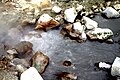
Cooking zone

Cooking hole
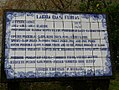
Information board at the lake as azulejo

Chapel of Nossa Senhora das Vitóras
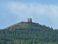
Castelo Branco over the lake


,_fachada,_Lagoa_das_Furnas,_ilha_de_S%C3%A3o_Miguel,_A%C3%A7ores..JPG)

Individual evidence
- ^ Arquipélago - Life and Marine Sciences, No. 25/2008, p. 79. According to an official information board on the lake, the lake is 1.76 km², is 280 m above sea level and is a maximum of 11 m deep.
- ^ Arquipélago - Life and Marine Sciences, No. 25/2008, p. 79
- ^ Governo dos Açores: Protected Landscape Area of Furnas. URL: http://parquesnaturais.azores.gov.pt/en/smiguel-eng/what-visit/protected-areas/protected-landscape-area/furnas accessed on September 30, 2011
- ^ Arquipélago - Life and Marine Sciences, No. 25/2008, p. 78
- ^ Arquipélago - Life and Marine Sciences, No. 25/2008, pp. 77-79
- ^ Arquipélago - Life and Marine Sciences, No. 25/2008, pp. 78, 80
- ^ Arquipélago - Life and Marine Sciences, No. 25/2008, p. 81
- ↑ Michael Bussmann: Azores. 4th edition. Michael Müller Verlag, Erlangen 2010, ISBN 978-3-89953-576-1 , p. 240