Garabi-Roncador
| Garabi-Roncador | |||||||
|---|---|---|---|---|---|---|---|
| Map of the planning area | |||||||
|
|||||||
|
|
|||||||
| Coordinates | 28 ° 10 ′ 0 ″ S , 55 ° 37 ′ 0 ″ W | ||||||
| Data on the structure | |||||||
| Lock type: | dam | ||||||
| Construction time: | not clear | ||||||
| Height of the barrier structure : | 78 m | ||||||
| Building volume: | 9.94 million m³ | ||||||
| Crown length: | 1 598 m | ||||||
| Power plant output: | 2 600 MW | ||||||
| Data on the reservoir | |||||||
| Water surface | 810 km² | ||||||
| Storage space | 33,580 million m³ | ||||||

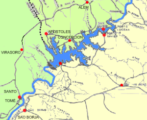
The Garabi-Roncador Dam is a dam in the planning stage with a hydroelectric power plant on the Uruguay River on the border between Argentina , Corrientes Province , and Brazil, Rio Grande do Sul state .
The planning has been going on since 1972, the first agreement was signed in 1981, and the project was changed again in 2009. The planning has not yet been completed (status: 2018-10-05).
The dam is planned with an installed hydropower capacity of 2600 MW (8.5 TWh annual energy production), of which 1800 MW (4.7 TWh) annually in the Garabí hydropower plant and 800 MW (3.8 TWh) in the Santa Maria hydropower plant . The dam is in the province of Corrientes, but the actual reservoir is essentially in the north in the Argentine province of Misiones and in Brazil, which is why the authorities in both countries are also involved in the negotiations.
The reservoir will have 81,000 hectares (810 km²) of water.
See also
- List of hydropower plants in Argentina
- List of dams in the world (Argentina)
- List of the largest dams on earth
- List of the largest reservoirs on earth
- List of the largest hydroelectric plants in the world
Web links
- Argentina y Brasil ratifican acuerdos por Garabí , Momarandu, November 20, 2007, accessed May 15, 2014

