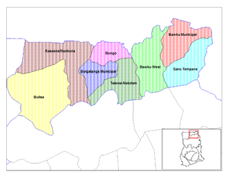
Garu-Tempane District
| Garu-Tempane District | |
|---|---|
| country |
|
| region | Upper East Region |
| Capital | Garu |
| District shape | Usually |
| District Chief Executive | Emmanuel Sin-Nyet. Asigri |
| surface | 1230 km² |
| population | 116,215 (2002) |
| Population density | 94 Ew. / km² |
The Garu-Tempane District was a district in the Upper East Region in northeast Ghana . The district was divided into the Garu District and the Tempane District in 2019 . 195 communities belonged to the district, the only urban area was the capital Garu . The district shared a border with neighboring Togo .
population
Members of the Kusasi , Busangas , Mossi, Bimobas and Mamprusi ethnic groups live in the area of the former district . The majority of the population is Mohammedan (51%), there are 9.2% Catholics , 4.3% Protestants , 4.5% Adventists and 26% followers of traditional religions.
Climate and vegetation
The climate is tropical with a wet season from May to October and a long dry season with practically no rainfall from October to April. Temperatures range between a maximum of 45 ° C in March / April and a minimum of 12 ° C in December. Characteristic is the hot harmattan that blows during the dry season.
economy
The district was dominated by agriculture, around 62% of the employees worked in this area. They produced corn , millet , peanuts , onions , watermelons and raised pigs, cattle, sheep and goats. Around 6.6% were employed in the public sector, 9.3% in food processing, 2.3% in leather / textiles and 19.8% in retail.
