
Upper East Region
| Upper East Region | |
|---|---|
  |
|
| country |
|
| Capital | Bolgatanga |
| District number | 15th |
| surface | 8,842 km² |
| population | 1,273,700 (2019) |
| Population density | 144 Ew. / km² |
| ISO 3166-2 | GH-UE |
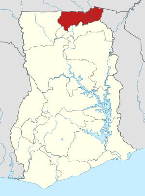
The Upper East Region ( Eng. "Upper East Region") is a region in Ghana . Its capital is Bolgatanga .
geography
The region is located in the far north-east of the country and borders on Burkina Faso in the north, Togo in the east, the North East Region in the south and the Upper West Region in the west . The rivers Red Volta and White Volta flow coming from Burkina Faso, from north to south through the region.
Population development
| Census year | population |
|---|---|
| 1960 | 468,638 |
| 1970 | 542.858 |
| 1984 | 772.744 |
| 2000 | 920.089 |
| 2010 | 1,046,545 |
Administrative structure
The region is divided into 15 districts :
Web links
Commons : Upper East Region - collection of images, videos, and audio files
- Upper East Region on ghanadistricts.gov.gh
Individual evidence
- ↑ 2010 Population & Housing Census. (No longer available online.) Archived from the original on July 12, 2018 ; accessed on September 4, 2018 .
- ↑ District list on ghanadistricts.gov.gh, accessed December 18, 2019