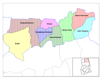
Bongo District
| Bongo District | |
|---|---|
| country |
|
| region | Upper East Region |
| Capital | Bongo |
| District shape | Usually |
| District Chief Executive | Francis A. Akurugu |
| surface | 488 km² |
| population | 77,894 (2002) |
| Population density | 160 Ew. / km² |
| ISO 3166-2 | GH-UE-BO |
The Bongo District in northeast Ghana is part of the Upper East Region . The district shares a border with neighboring Burkina Faso .
population
Members of the Bossi and Frafra- speaking Tallensi ethnic groups live in the district . The majority of the population adheres to traditional religions (53.6%), there are 28.3% Christians and followers of Islam (6.4%).
Climate and vegetation
The climate is tropical with a wet season from May to October and a long dry season with practically no rainfall from October to April. Temperatures range between a maximum of 45 ° in March / April and a minimum of 12 ° in December. Characteristic is the hot harmattan that blows during the dry season.
economy
The district is dominated by agriculture.
Locations in the district
- Soe Soboko
- Gowrie-Tingre
- Zoko Tarongo
- Lungu
- Dua
- Namoo
- Zoko-Kodorogo
- Bongo Nyariga
- Zoko Kanga
- Adaboya
- Bogorogo
- Gowrie Nayire Central Zoko-Gambrongo-Azaabisi
- Zoko-Gambrongo
- Seo-Asabagabisi (Wabisi)
- Vea-Akugrebisi
- Zoko-Goo
- Dua Apuwongo
- Balungu-Gantorisi.
