
Giesinger Berg
| Giesinger Berg | |
|---|---|
|
|
|
.jpg) |
|
| End of the Giesinger Berg at the Martin Luther Church | |
| Basic data | |
| State capital | Munich |
| Borough | Au-Haidhausen, Obergiesing-Fasangarten |
| Name received | 1894 |
| Connecting roads | Humboldtstrasse, Martin-Luther-Strasse |
| Cross streets | Hebenstreitstrasse, Ichostrasse, Silberhornstrasse |
| use | |
| User groups | Pedestrian traffic , bicycle traffic , individual traffic , public transport |
| Technical specifications | |
| Street length | 320 m |
The Giesinger Berg is a 20 m high Munich hill south of Columbus Square, on the border between Obergiesing and Untergiesing . The approximately 320 m long, now four-lane road that leads up this hill bears this name.
history
The hill was created in the Ice Age as part of the eastern Isar high bank . Later it connects the former farming village of Obergiesing on Ichostraße on the edge of the Isar slope with the settlements in the valley on Columbusplatz.
The increasing volume of traffic in the 18th and 19th centuries made the steep Berggasse a dangerous stretch of road. The most prominent traffic victim was the entrepreneur and inventor Joseph von Utzschneider . His carriage tipped and overturned on January 31, 1840 in the "Loherwirtskurve". The straightening of the alley also had to give way to the old Holy Cross Church in 1888. The new Holy Cross Church stands above the Giesinger Berg . Terrain regulations took place on Giesinger Berg in 1890/1892 and 1934/1935. The incline has been reduced from 15 percent in places to four percent. The incline was also a challenge during the construction of the underground in 1976/1978. The first mention is dated to 1894. From 1896 the tram ran over the Giesinger Berg, which was discontinued in 1983.
During the revolutionary period after the end of the war in 1918, the Giesinger Berg was defended for two days (ultimately unsuccessfully) against Reichswehr troops and Freikorps units who wanted to occupy Munich.
For several years there have been considerations to build a pedestrian and bicycle bridge from the Holy Cross Church to the Giesinger Bräu opposite (or to the Bergstrasse behind it). This would close a gap in the largely low-traffic connection along the upper edge of the Isar slope from Gasteig to Grünwald.
Today the mountain is part of the Obergiesing-Fasangarten cultural history trail .
Illustrations
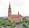
Holy Cross Church on Giesinger Berg

Historical view of the Giesing hill (around 1850) with the old Holy Cross Church, which was demolished in 1888

Outside staircase on Giesinger Berg to the Holy Cross Church

Plaque
_-_Kopie.jpg)


Web links
Individual evidence
- ^ Hans Dollinger: The Munich street names. 5th edition. Ludwig Verlag, Munich 2004, ISBN 3-7787-5174-3
- ↑ a b Hildegard Adam: Giesing from the village to the city district . Ed .: Thomas Guttmann. 4th edition. Buchendorfer Verlag, Munich 2004, ISBN 3-927984-04-3 , subsurface and surface form Giesings, p. 21 (first edition: 1990).
- ↑ https://www.muenchen.de/rathaus/dam/jcr:2adae1ce-7c7b-4d65-aa57-26f37b677014/KGP17_booklet_auflage2_screen.pdf
- ↑ https://stadt-muenchen.net/strassen/d_strasse.php?id=1707
- ↑ Peter Brenner: The tram line 17. Accessed on July 29, 2018 .
Coordinates: 48 ° 7 '2.7 " N , 11 ° 34" 37.3 " E