
Untergiesing-Harlaching
|
Untergiesing-Harlaching
State capital Munich
Coordinates: 48 ° 5 ′ 32 " N , 11 ° 33 ′ 38" E
|
|
|---|---|
| Area : | 8.06 km² |
| Residents : | 53,243 (Dec. 31, 2019) |
| Population density : | 6,609 inhabitants / km² |
| Postcodes : | 81543, 81545, 81547 |
| Area code : | 089 |
 Location of the city district 18 Untergiesing-Harlaching in Munich
|
|
 Columbus Square
|
|
_-_Untergiesing_-_Harlaching.png)
Untergiesing-Harlaching is the city district 18 of the Bavarian capital Munich .
The once clearly drawn social boundaries between old Harlaching with upper class , Neuharlaching with lower and middle social classes and Untergiesing as a classic working-class district are increasingly losing their shape. Overall, the district has a high number of skilled workers. The age distribution suggests an impending aging population.
location
Untergiesing
The Untergiesing district is bounded in the northwest by the eastern bank of the Isar and the Au-Haidhausen district along Humboldtstrasse. To the northeast and east leads the boundary to the municipality obergiesing the Giesing Berg and Martin Luther street and then head southeast along the Tegernsee road to St. Quirin Platz lead. There, the district border makes a bend along Soyerhofstrasse, and then at Mangfallplatz via Peter-Auzinger-Strasse again into Tegernseer Landstrasse. At the transition from the Tegernseer Landstrasse to the A 995 , the border continues to the south-west, along the northern edge of the Perlacher Forest . Untergiesing turns into Harlaching at Eichthalstrasse.
Harlaching
The Harlaching district is located in the southeast of Munich on the elevated terrace of the right bank of the Isar , from which it is bordered to the west. To the south it ends at the city limits of Grünwald . In the southeast, the city limits run along the edge of the forest of the municipality-free Perlacher Forest, which lies between Munich, Grünwald and Unterhaching and Deisenhofen . To the north-east and north, Harlaching borders the Untergiesing district, with which it forms the 18 Untergiesing-Harlaching district. District 18 also includes the eastern Isar and Flaucher facilities below the edge of the slope on the border with Thalkirchen , which, together with the Hellabrunn Zoo, have played an important leisure and recreational role for the city in this section , especially since the renaturation of the Isar .
history
Untergiesing


In contrast to Obergiesing, Untergiesing did not come into being for the most part until the 19th and 20th centuries. Before that, only the alluvial forest, the Lohe , had been inhabited since the 15th century , and there were individual structures, especially mills, along the Auer Mühlbach . The oldest written mill was the Bäcker-Kunstmühle below today's Grünwalder Stadium on the site of today's Bäckermühle power plant , which was first mentioned in 957 in a document in which the noble Wolftregil owned the mill at Kiesingenum ( Giesing ) and the property belonging to the bishop of Freising transferred.
Until the reorganization of the Munich boroughs in 1909, Unter- and Obergiesing were one unit and formed the rural community of Giesing . The name Untergiesing was previously used for the settlement below the Nockherberg , which belonged to the municipality of Au before it was incorporated into Munich .
The small hostels (workers' apartments) that were characteristic of Untergiesing in the past can still be found in the Pilgersheimer Straße, named after the Pilgramsheim castle built in 1784 by the court banker Franz Anton Pilgram. The Mayersche leather factory was also located here. Founded in 1808 and broken up in 1930, it was Giesing's first major industrial company. Today , the housing estate of Münchner Siedlungsbau, built in 1930/31 in the New Objectivity style, is located there .
Harlaching


In the Harlaching area, archaeological finds testify to the first human settlements from the Iron Age . Several grave finds from different epochs indicate a thin but persistent Celtic settlement. The first written mention of the place can be found around 1150 as "Hadaleichingen". The name indicates a (developed) personal name "Hadaleih". It is believed that around 600 a Germanic clan chief founded or took over the settlement that has been named after him ever since. A more recent attempt at derivation refers to the designation "Harlachen" for forest clearing and is based on the assumption of a false "-ing" place name. Against this thesis, however, speaks the fact that the earliest traditional name form is not "Harlach-", but "Hadaleih-", with the variants "Hadelaich-en", "Hadelah-ingen" and "Hadelich-ingen".
The old town center was around St.-Anna-Kircherl on Harlachinger Berg, which was first guaranteed in writing in 1186 as belonging to the Tegernsee Monastery . The few houses were surrounded by forests and meadows. The Harlachingen Castle was later built near the church , which burned down in 1796 and no longer exists today. The first community formation with the establishment of a patrimonial court took place in 1818 together with Geiselgasteig , Harthausen, Hellabrunn , Laufzorn , Siebenbrunn and Wörnbrunn . Harlaching later became part of the Giesing community for a short time . On October 1, 1854, the area with around 50 inhabitants and its already popular excursion destinations such as the Menterschwaige was incorporated into Munich.
From around 1900 an increasingly rapid construction activity began on the former agricultural land. At the beginning of the 20th century, the garden city of Harlaching , which was built on the site of the former palace and has been able to retain its green character, was first created according to plans by architects Gabriel von Seidl and Max Littmann . The Menterschwaige villa colony of the same company followed on the banks of the Isar. In 1910, after long negotiations with the community of Grünwald and many landowners, the tram line between the city center of Munich and the market square of Grünwald was opened as the "Isar Valley outer line" (today lines 15/25). This increased the popularity of weekend trips to the Isar valley between Flaucher and Grünwald by leaps and bounds, and the pressure to settle also increased. In 1911, the Hellabrunn zoo was opened in the Isar floodplain , which attracted more visitors. Alt-Harlaching with Menterschwaige is today a spacious and prestigious villa district with the highest rental prices in Munich that emerged from the garden city idea. In Neuharlaching, northwest of Alt-Harlaching, development began around 1920 with simple private homes and loose development with often non-profit apartment buildings such as B. in the flat settlement Neuharlaching . The “Reichs-Klein-Siedlung” (Reichs-Klein-Siedlung) was built there as a social settlement project in the 1920s; “For participants in the Hitler putsch of 1923. Apartments were also built for employees of the nearby Reichszeugmeisterei of the NSDAP . After 1945 this was taken over by the US Army as part of the McGraw barracks . In addition, parts of Altharlaching's houses were confiscated by the American army to accommodate members of the armed forces, the area was fenced in and could only be entered and left at guarded crossings. It was not until 1954 that the US housing estate on Perlacher Forst ("Ami settlement") was built, and the Harlaching areas were freed from barbed wire. Since 1956, the “Little Octoberfest”, initiated by the US troops, has taken place annually in the American settlement, the tradition of which was continued until 2005 by German showmen even after the troops had withdrawn. In the years 1959-1965 the Harlaching municipal hospital was built on a park area of the former municipal sanatorium with old trees. This hospital is equipped with all the necessary departments to ensure basic medical and medical care. It has had the status of an academic teaching hospital since the 1970s and is the largest employer in the district, which otherwise mainly offers jobs in the service sector. Likewise, with the stationing of the rescue helicopter " Christoph 1 " by the ADAC on November 1, 1970, the first continuous operation of a rescue helicopter in Germany began at the Harlaching municipal hospital . After German reunification and the withdrawal of the US Army from Munich, various departments of the Munich police moved into the former McGraw barracks in 1992, the apartments of the army members in the Ami settlement were partly converted into social housing and partly into free ones Housing market laid off. The development of Harlaching is becoming increasingly dense, especially since since the 1970s many one and two-family houses have been demolished and replaced by condominiums. The urban image of Neuharlaching is changing today due to numerous new buildings, the border to the increasingly densely built-up Old Harlaching is becoming blurred.
The Christian church life of Harlaching takes place in three Catholic parishes and one Protestant parish. The St. Anna Church was added as a branch church of the Catholic parish Holy Family , whose church was consecrated in 1931 as the first “modern” parish church in Munich, followed in 1945 by Maria Immaculata , in whose parish the Marienklause is located below on the Isar slope , and in 1964 came the Parish of St. Helena on the border with Obergiesing was added. The evangelical Emmaus community was founded in 1940.
politics
The district committee of Untergiesing-Harlaching was last elected on March 15, 2020. The distribution of seats is as follows: Greens 10, CSU 6, SPD 5, FW / ÖDP 2, FDP 1 and AfD 1. Of the 40,283 residents of Untergiesing-Harlaching who are entitled to vote, 21,242 have exercised their right to vote, bringing the turnout to 52.7 Percent lay.
Club life and social activity
Citizens' initiative "More space to live"

The citizens' initiative "More space to live", an Agenda 21 project, has been campaigning for the redesign of Hans-Mielich-Platz since 1997 with various actions and district festivals, initiated the weekly market, set up a number of Christmas trees and invited everyone to decorate the square together and thus created a cultural center. In 2011 the square was redesigned and is now an 8,500 m² varied area with a children's playground and an open-air chess organized by the citizens' initiative, donated by the FC Bayern chess club. In 2008 she founded the art forum HMP, temporary art in public space with numerous exhibitions, in order to contribute to the revitalization on site. In the past, the citizens' initiative has the sidewalk in Hans-Mielich-Str. recaptured and embellished the street and the Candidplatz with "mini gardens". The opening of their sculpture park with the installation of the “mini maypole of communication” in the beer garden of the restaurant in Siebenbrunn met with a lot of applause. With audio walks through the quarter and “Ramadama” campaigns, she conveys sustainability and with planting, painting and art events that connect generations, she ensures networking in the quarter.
Burschenverein Harlaching
On May 25, 2008, the Harlaching Boys' Association was founded. The association has set itself the goal of maintaining Bavarian customs and also shows social commitment. The still young association now has over 30 members. Since 2009 the boys' festival of the BV-Harlaching takes place annually in May.
TSV Turnerbund Munich
The TSV Turnerbund München e. V. , founded in 1882, is one of the largest and oldest popular sports clubs in Munich with around 3,400 members and a total of twelve departments. It offers its members a comprehensive program from small children’s gymnastics to senior sports.
Buildings and infrastructure
Stadium on Grünwalder Strasse
On “Giesings Heights” on the corner of Candidstrasse ( Mittlerer Ring ) and Grünwalder Strasse , the stadium on Grünwalder Strasse has been used as a football stadium since 1911 . In 1925 it was expanded. It is closely linked to the history of TSV 1860 Munich . From 1963 to 1972 the Bundesliga and European Cup matches of TSV, but also FC Bayern Munich, took place here. The building, popularly known as the Sechzger Stadium , became a symbol of the fans' loyalty to their club during the TSV's Bayern League period. The move of the lions to the Olympic Stadium led to internal crises. For the 2004/05 season, the TSV temporarily returned to the "Grünwalder". Since relegation to the amateur area in 2017, the stadium has again been the home of the TSV. Giesing is a Munich football stronghold, as both large clubs have their training grounds and offices in the district.
market
As a weekly market , a farmers' market is usually held on Wednesdays between 2 and 6 p.m. on Mangfallplatz , and on Thursdays between 1 and 6 p.m. a weekly market on Hans-Mielich-Platz.
Architectural monuments
The Kutscherviertel in Untergiesing is located between the Columbusplatz underground station and the Schyrenbad . It was the quarter for hired coachmen , goose fatteners and poultry dealers. Some of the typical one-story buildings from around 1840 were still preserved until 2011, but were torn down in order to build a new apartment building.
statistics

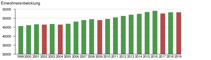
(As of December 31, residents with main residence)
| year | Residents | including foreigners | Inhabitants per km² |
|---|---|---|---|
| 2000 | 46.153 | 8,717 (18.9%) | 5,726 |
| 2001 | 46,580 | 8,892 (19.1%) | 5,779 |
| 2002 | 46,495 | 8,949 (19.2%) | 5,769 |
| 2003 | 46,706 | 9,149 (19.6%) | 5,795 |
| 2004 | 46,462 | 8,979 (19.3%) | 5,765 |
| 2005 | 46,857 | 9,196 (19.6%) | 5,814 |
| 2006 | 48,075 | 9,337 (19.4%) | 5,963 |
| 2007 | 48,990 | 9,659 (19.7%) | 6,072 |
| 2008 | 49.391 | 9,765 (19.8%) | 6.131 |
| 2009 | 48,911 | 9,263 (18.9%) | 6,071 |
| 2010 | 49.502 | 9,574 (19.3%) | 6,144 |
| 2011 | 50,455 | 10,179 (20.2%) | 6.263 |
| 2012 | 51,180 | 10,649 (20.8%) | 6,353 |
| 2013 | 51,937 | 11,400 (21.9%) | 6,446 |
| 2014 | 52,452 | 11,839 (22.6%) | 6,510 |
| 2015 | 53,377 | 12,929 (24.2%) | 6,625 |
| 2016 | 54,050 | 13,534 (25.0%) | 6,709 |
| 2017 | 52,600 | 12,346 (23.5%) | 6,529 |
| 2018 | 53,184 | 12,832 (24.1%) | 6,601 |
| 2019 | 53,243 | 12,908 (24.2%) | 6,609 |
Source with further data
literature
- Thomas Guttmann (Ed.): Giesing: From the village to the district. Contributions to the past and present Giesings and Harlachings , MünchenVerlag (formerly Buchendorfer Verlag), Munich 2004, 4th edition, ISBN 978-3-927984-04-2
- Andreas Grad: Harlaching, from Miocän to today , Munich 1974. 4 ° Mon. 5 917
- Dorle Gribl: Harlaching and the Menterschwaige - From Noble Seat to Garden City . Buchendorfer / MünchenVerlag GmbH: Munich 2004. ISBN 3-937090-05-3
- Karl, Willibald (ed.): Giesinger heads. 50 life pictures from two centuries , Volk Verlag, Munich 2008, ISBN 978-3-937200-55-2
- Greipl, Egon Johannes (ed.): Münchner Lebenswelten im Wandel. Au, Haidhausen, Giesing 1890-1914 , Volk Verlag, Munich 2008, ISBN 978-3-937200-51-4
Web links
- Untergiesing district - state capital Munich
- Harlaching district - state capital Munich
- City District and District Committee 18 Untergiesing-Harlaching - City of Munich
- Topography (1975) suburb of Giesing
Individual evidence
- ↑ Statistical Pocket Book 2020 (PDF). Statistical Office of the State Capital Munich. Retrieved August 24, 2020.
- ^ Wilhelm Volkert (ed.): Handbook of Bavarian offices, communities and courts 1799–1980 . CH Beck, Munich 1983, ISBN 3-406-09669-7 , p. 601 .
- ↑ a b c Election of the District Committee - District 18 - Untergiesing-Harlaching . State capital Munich. Retrieved June 10, 2020.
- ↑ TSV Turnerbund München e. V.
- ↑ Johannes Welte: Birkenau: Now it is being demolished. In: tz. Zeitungsverlag tz Munich, July 21, 2011, accessed on December 2, 2015 .
- ^ Archive district information . State capital Munich. Retrieved January 6, 2019.

Allach-Untermenzing (23) | Altstadt-Lehel (1) | Au-Haidhausen (5) | Aubing-Lochhausen-Langwied (22) | Berg am Laim (14) | Bogenhausen (13) | Feldmoching-Hasenbergl (24) | Rags (20) | Laim (25) | Ludwigsvorstadt-Isarvorstadt (2) | Maxvorstadt (3) | Milbertshofen-Am Hart (11) | Moosach (10) | Neuhausen-Nymphenburg (9) | Obergiesing pheasant garden (17) | Pasing-Obermenzing (21) | Ramersdorf-Perlach (16) | Schwabing-Freimann (12) | Schwabing-West (4) | Schwanthalerhöhe (8) | Sendling (6) | Sendling-Westpark (7) | Thalkirchen-Obersendling-Forstenried-Fürstenried-Solln (19) | Trudering-Riem (15) | Untergiesing-Harlaching (18)