
Obergiesing pheasant garden
|
Obergiesing pheasant garden
State capital Munich
Coordinates: 48 ° 6 ′ 40 ″ N , 11 ° 35 ′ 40 ″ E
|
|
|---|---|
| Area : | 5.72 km² |
| Residents : | 54,498 (Dec. 31, 2019) |
| Population density : | 9,527 inhabitants / km² |
| Postcodes : | 81539, 81541, 81547, 81549 |
| Area code : | 089 |
 Location of the city district 17 Obergiesing-Fasangarten in Munich
|
|
_-_Obergiesing.png)


Obergiesing-Fasangarten is the city district 17 of the Bavarian capital Munich .
Together with the Untergiesing-Harlaching district, it roughly encompasses the historic community of Giesing and the Fasangarten settlement on what was formerly Perlach .
location
Obergiesing lies above the Isar slope on the eastern Isarhchterrasse. Today's urban district 17 Obergiesing-Fasangarten extends as a narrow strip between the southeast section of the Middle Ring and the S-Bahn line to Kreuzstrasse (Valley) , in Alt-Giesing it includes parts of the inner city outskirts and extends to the southeastern outskirts with the Fasangarten and the former American settlement .
The city district 17 borders (clockwise) on the districts Untergiesing-Harlaching in the west, Au-Haidhausen in the north and Ramersdorf-Perlach in the east, on the communities Neubiberg and Unterhaching in the south and on the community-free area Perlacher Forst in the southwest.
history
The district of Obergiesing was created in 1936 by dividing the district of Giesing , which was incorporated in 1854, into the districts of Obergiesing and Untergiesing-Harlaching .
In 1890/1910 Obergiesing experienced its first major expansion phase. On the Tegernseer Landstrasse and its side streets, large city houses are being built in the style of historicism . The creation of new living space went hand in hand with new cultural buildings, such as schools and churches. The next construction phase in 1928/1939 was designed by non-profit housing associations . In Obergiesing, four-story buildings that are arranged around large inner courtyards were characteristic. This can still be found today, for example, between Tegernseer Landstrasse and Giesinger Bahnhof. The "Reichskleinsiedlung am Perlacher Forst", located on Holtzendorffstrasse, was created in 1923/1933 out of the need of unemployment. The unemployment rate was around 73%. The future residents had to help build the houses. The houses had large gardens for keeping small animals and kitchen gardens .
While the adjoining districts suffered a decline in population due to the Second World War , the numbers in Obergiesing went up; a fictitious profit from the overcrowding of living space in times of need. With the beginning of the post-war period, the reconstruction of houses destroyed in the war and the development of building land reserves led to brisk new construction activity, around three quarters of the housing stock was built after 1948. This next construction phase ran from around 1950 to 1965. The aim was to combat the housing shortage caused by bombs, refugees and job seekers. The main carrier of the construction work was the Neue Heimat . In 1953/1958 a residential complex with 71 houses, a kindergarten, school, library, restaurant, etc. was built between Giesinger Bahnhof and Stadelheim. In 1945, the American occupation forces took over the former Reichszeugmeisterei on Tegernseer Landstrasse as the main barracks. In the Weissensee-, Chiemgau- and Stettnerstraße area, 22 apartment blocks were also built for American army personnel.
Only in Alt-Giesing , primarily around the neo-Gothic hall church Heilig Kreuz , built in 1886 on the edge of the Isar slope on Giesinger Berg , have individual historical suburban ensembles been preserved. In 1937 a new curative parish was separated from the parish Heilig Kreuz, which has been an independent parish since 1941; the associated parish church Maria Königin des Friedens is the work of Robert Vorhoelzer , who is otherwise known in Munich for his post offices. Apart from the Ostfriedhof , the cemetery at Perlacher Forst and the Weißenseepark , Obergiesing has hardly any green spaces worth mentioning. Industrial and commercial areas were concentrated between Perlacher Strasse and Tegernseer Landstrasse . After the AGFA factory site was demolished, this part of Obergiesing was mainly built on with apartments.
The urban structure in Obergiesing is very heterogeneous. Single-family houses and small settlements alternate with areas of loosened-up apartment buildings and densely populated block development. The service sector has now overtaken manufacturing in terms of the number of jobs. As in other former workers' and craftsmen's quarters, the social structure in Obergiesing has now balanced out, but a relatively low rent level ensures that living space in Obergiesing is still affordable for lower-income groups and families with children. The proportion of foreigners is therefore in the upper range of the Munich districts. The process of gentrification and densification of living space continues .
Pheasant garden
Today the district of Obergiesing also includes the Fasangarten settlement that was built in the 1920s and was incorporated into Munich in 1937 as part of the Perlach community. The pheasant garden, which never belonged to Giesing before the incorporation, has an independent character, predominantly characterized by single-family houses. In order to take this into account, the official name of the city district was changed to Obergiesing-Fasangarten at the end of 2009. The settlement at the Perlacher Forst , also known as the "Ami settlement", is an integral part of the pheasant garden.
politics
The district committee of Obergiesing-Fasangarten was last elected on March 15, 2020. The distribution of seats is as follows: Greens 11, SPD 6, CSU 5, FW 1, FDP 1 and AfD 1. Of the 38,487 residents who are entitled to vote in Obergiesing-Fasangarten, 17,910 exercised their right to vote, bringing the turnout to 46.5 percent .
Architectural monuments
statistics
Population development
Residents with main residence as of December 31st

| year | Residents | including foreigners | Inhabitants per km² |
|---|---|---|---|
| 2000 | 43,974 | 12,035 (27.4%) | 7,696 |
| 2001 | 44,143 | 11,981 (27.1%) | 7,725 |
| 2002 | 44,616 | 12,035 (27.0%) | 7,808 |
| 2003 | 44,761 | 12,478 (27.9%) | 7,838 |
| 2004 | 44,473 | 12,197 (27.4%) | 7,786 |
| 2005 | 45.132 | 12,339 (27.3%) | 7,901 |
| 2006 | 47.007 | 12,914 (27.5%) | 8,224 |
| 2007 | 47,791 | 13,153 (27.5%) | 8,362 |
| 2008 | 48,282 | 13,394 (27.7%) | 8,445 |
| 2009 | 48,425 | 13,407 (27.7%) | 8,481 |
| 2010 | 49.030 | 13,665 (27.9%) | 8,577 |
| 2011 | 50,656 | 14,509 (28.6%) | 8,855 |
| 2012 | 51.183 | 14,909 (29.1%) | 8,948 |
| 2013 | 51,499 | 15,047 (29.2%) | 9.003 |
| 2014 | 52,743 | 15,858 (30.1%) | 9,220 |
| 2015 | 54,402 | 16,823 (30.9%) | 9,510 |
| 2016 | 54,784 | 17,272 (31.5%) | 9,594 |
| 2017 | 53,937 | 16,617 (30.8%) | 9,429 |
| 2018 | 54,256 | 16,856 (31.1%) | 9,485 |
| 2019 | 54,498 | 17,053 (31.3%) | 9,527 |
Source with further data
various
- In the Stadelheim district is the Munich correctional facility , which is often simply called Stadelheim for short .
- Hans and Sophie Scholl , as well as Christoph Probst , resistance fighters of the White Rose , were executed in the Munich-Stadelheim prison and are buried in the adjoining cemetery at Perlacher Forst , as is resistance fighter Walter Klingenbeck .
- The first McDonald’s restaurant in Germany opened on December 4, 1971 in Giesing at Martin-Luther-Straße 26 and quickly enjoyed great popularity not only with the US occupation troops ( McGraw barracks ) stationed nearby at the time .
- Franz Beckenbauer grew up in Zugspitzstrasse 6 and learned to play football on the hard court of SC Munich from 1906 .
- Max Greger , world-famous jazz musician, was born here.
- The once striking AGFA high-rise was blown up on February 17, 2008. In the following years, a large new building and commercial area was built on this former AGFA site.
- Rex Gildo , pop musician, and Rudolph Moshammer , fashion designer, were buried in the Ostfriedhof .
- Directly across the border to the Au district lies the Nockherberg , which is well known across the region thanks to the Paulaner beer garden and the Derblecken that takes place there .
traffic


The railway line Munich Ost – Deisenhofen , which partially borders the district in the east , leads the S-Bahn lines S3 and S7 coming from the Ostbahnhof via the stations St.-Martin-Straße and Munich-Giesing station out of town, with the special feature that this section of the route Due to the change in the direction of travel at the Ostbahnhof, it is operated in left-hand traffic and not, as is usual with Deutsche Bahn, in right-hand traffic. After the train station in Giesingen, an overpass leads to traffic on the right again. Shortly after the restoration of right-hand traffic, the two lines separate; the S7 now runs on the Munich-Giesing – Kreuzstrasse railway line that branches off here , which from now on forms the district border, the S3 serves on its way to Holzkirchen in the district to the Fasangarten station.
The underground line U2 crosses the district from west to east and serves the stations Silberhornstraße and Untersbergstraße before it crosses the S3 and S7 at Giesingen train station. The St.-Quirin-Platz station on the U1 line is also just beyond the south-western district boundary.
Tram line 18 runs from its terminus Schwanseestrasse, which is located directly at the Perlacher Forst cemetery and near the Stadelheim correctional facility , via Giesing station to the city center. At the Ostfriedhof it crosses lines 15 and 25, which , coming from Rosenheimer Platz , meet the U2 at Silberhornstraße and continue towards Grünwald .
The central junction for public transport is the Giesing train station, where, in addition to the S-Bahn, U-Bahn and tram, two Metrobus lines (54 and 59), two city bus lines (139, 147) and the regional bus line 220 run to Unterhaching. The second important traffic junction is the Silberhornstraße underground station, here the U2 meets the tram, the Metrobus line 58, the city bus line 148 and the express bus line X30, which leads via a few stops to Sendling and Haidhausen . The extreme south of the district is accessible via line 145 (Ostbahnhof – Fasangarten).
In addition, on opening days, line 07 runs from Giesingen train station with a vintage bus to the MVG Museum at Ständerstraße 20.
The A 995 , which separates Giesing from the Perlacher Forst in the west, joins the Tegernseer Landstrasse, which runs in the McGraw-Graben and meets the Mittlerer Ring. It connects the south-western end of the district with the A 8 and is at the same time the - currently southern - end piece of the not yet completed Munich motorway ring.
gallery
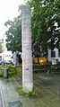
Giesing historical column for 1200 years of Giesing 790–1990

Golden back of the commercial building at Tegernseer Landstrasse 64


literature
- Willibald Karl (ed.): Giesinger heads. 50 life pictures from two centuries. Volk Verlag, Munich 2008, ISBN 978-3-937200-55-2 .
- Egon Johannes Greipl (Ed.): Münchner Lebenswelten im Wandel. Au, Haidhausen, Giesing 1890–1914. Volk Verlag, Munich 2008, ISBN 978-3-937200-51-4 .
- Thomas Guttmann (Ed.): Giesing - From the village to the district. MünchenVerlag (formerly Buchendorfer Verlag München), Munich 2004, ISBN 978-3-927984-04-2 .
Web links
- District Obergiesing - state capital Munich
- City district and district committee 17 Obergiesing-Fasangarten - City of Munich
- Topography (1975) suburb of Giesing
Individual evidence
- ↑ Statistical Pocket Book 2020 (PDF). Statistical Office of the State Capital Munich. Retrieved August 24, 2020.
- ↑ Hildegard Adam: Giesing from the village to the district . Giesing's geographical situation. Ed .: Thomas Guttmann. 4th edition. Buchendorfer Verlag, Munich 2004, ISBN 3-927984-04-3 , p. 17 (first edition: 1990).
- ↑ Hildegard Adam: Giesing from the village to the district . Ed .: Thomas Guttmann. 4th edition. Buchendorfer Verlag, Munich 2004, ISBN 3-927984-04-3 , Differentiation of the building history of the former Giesingen district, p. 42, 43 (first edition: 1990).
- ↑ Hildegard Adam: Giesing from the village to the district . Ed .: Thomas Guttmann. 4th edition. Buchendorfer Verlag, Munich 2004, ISBN 3-927984-04-3 , Differentiation of the building history of the former Giesingen district, p. 45, 46 (first edition: 1990).
- ↑ Hildegard Adam: Giesing from the village to the district . Ed .: Thomas Guttmann. 4th edition. Buchendorfer Verlag, Munich 2004, ISBN 3-927984-04-3 , Giesing's population explosion as a city district, p. 31,32 (first edition: 1990).
- ↑ Hildegard Adam: Giesing from the village to the district . Ed .: Thomas Guttmann. 4th edition. Buchendorfer Verlag, Munich 2004, ISBN 3-927984-04-3 , Differentiation of the building history of the former Giesingen district, p. 46, 47 (first edition: 1990).
- ↑ Hildegard Adam: Giesing from the village to the district . Ed .: Thomas Guttmann. 4th edition. Buchendorfer Verlag, Munich 2004, ISBN 3-927984-04-3 , Differentiation of the building history of the former Giesingen district, p. 47, 48 (first edition: 1990).
- ↑ a b c Election of the District Committee - District 17 - Obergiesing-Fasangarten . State capital Munich. Retrieved May 1, 2020.
- ^ Archive district information . State capital Munich. Retrieved January 6, 2019.
- ↑ Biggest explosion in Munich - the fall of a landmark. sueddeutsche.de, accessed on July 3, 2009 ( page no longer available , search in web archives ) Info: The link was automatically marked as defective. Please check the link according to the instructions and then remove this notice.

Allach-Untermenzing (23) | Altstadt-Lehel (1) | Au-Haidhausen (5) | Aubing-Lochhausen-Langwied (22) | Berg am Laim (14) | Bogenhausen (13) | Feldmoching-Hasenbergl (24) | Rags (20) | Laim (25) | Ludwigsvorstadt-Isarvorstadt (2) | Maxvorstadt (3) | Milbertshofen-Am Hart (11) | Moosach (10) | Neuhausen-Nymphenburg (9) | Obergiesing pheasant garden (17) | Pasing-Obermenzing (21) | Ramersdorf-Perlach (16) | Schwabing-Freimann (12) | Schwabing-West (4) | Schwanthalerhöhe (8) | Sendling (6) | Sendling-Westpark (7) | Thalkirchen-Obersendling-Forstenried-Fürstenried-Solln (19) | Trudering-Riem (15) | Untergiesing-Harlaching (18)