
Ludwigsvorstadt-Isarvorstadt
|
Ludwigsvorstadt-Isarvorstadt
State capital Munich
Coordinates: 48 ° 7 '38 " N , 11 ° 33' 53" E
|
|
|---|---|
| Area : | 4.4 km² |
| Residents : | 51,933 (Dec. 31, 2019) |
| Population density : | 11,799 inhabitants / km² |
| Postal code : | 80335, 80336, 80337, 80469 |
| Area code : | 089 |
 Location of the city district 2 Ludwigsvorstadt-Isarvorstadt in Munich
|
|
_-_Ludwigsvorstadt_-_Isarvorstadt.png)
.jpg)

Ludwigsvorstadt-Isarvorstadt is the city district 2 of the Bavarian capital Munich .
The city district consists of the districts Ludwigsvorstadt and Isarvorstadt .
location
The city district was created in 1992 from the amalgamation of Ludwigsvorstadt southwest of the city center with the three Isarvorstadt districts Isarvorstadt / Schlachthofviertel, Isarvorstadt / Glockenbachviertel and Isarvorstadt / Deutsches Museum southeast of it and encompasses the southern part of the old town like a clasp. With the green belt along the Isar , the old southern cemetery and the Theresienwiese , the district includes significant open spaces and green areas in the southern inner city area.
The boundaries of the city district form from north to east the streets Arnulf- , Sonnen- , Müller- , Rumford- and Zweibrückenstraße, in the southeast the Isar , in the southwest the railway tracks of the Munich Südring and in the west the Theresienhöhe and the Hackerbrücke. The border between the two districts Ludwigsvorstadt and Isarvorstadt runs along Lindwurmstrasse . Since this is a continuation of Sendlinger Straße, which forms the border between Hacken- and Angerviertel in the old town , the Ludwigsvorstadt was originally called the outer Hackenviertel and the Isarvorstadt was called the outer Angerviertel . The southern part of the Museum Island (south of the Ludwigsbrücke ) also belongs to the Isarvorstadt.
Neighboring districts are Maxvorstadt in the north, Altstadt-Lehel in the northeast, beyond the Isar Au-Haidhausen in the east and Untergiesing-Harlaching in the southeast, Sendling in the south and the Schwanthalerhöhe in the west.
History and structure today
The structures and functions of the urban district are influenced by the development history and vary greatly depending on the district: The station district around the main train station was largely destroyed by Allied air raids in World War II and rebuilt with residential and commercial buildings after the war. In addition to many wholesalers and retailers, there are numerous hotels and restaurants, sex shops, computer and electronics stores and international snack bars in the vicinity of the station. The street scene is heavily influenced by immigrants, especially from Turkey. In the Wiesenviertel with the Theresienwiese as the Oktoberfest venue, which was designed in the middle of the 19th century as a representative villa and apartment building district, the office space predominates today. The most striking building is the neo-Gothic Paulskirche . To the east of the Wiesnviertel is the clinic quarter , which is characterized by the buildings of the downtown clinics of the Ludwig Maximilians University . The station and clinic districts are connected by Schillerstrasse .
In 1819 the Isarvorstadt only had 2,300 inhabitants and comprised 183 houses and 19 state or municipal buildings. Because of the numerous streams, millers, gardeners, milkmen, washers, bleachers, carpenters, raft masters, horse traders and day laborers lived here in often poor dwellings. The town's Pechsieder lived in today's Palmstrasse (then Pechwinkel) . The old crushing and plague house for the seriously ill was located between two city streams between Baumstrasse and Auenstrasse . Another crushing house was located on today's Erhardtstrasse. At the beginning of the 18th century, the Bavarian Army moved into the Isarvorstadt. On the north side of Zweibrückenstrasse was the gallows of the Bavarian military justice . A military hospital was built on Müllerstrasse in 1775. The Electoral Isar Barracks was built on today's Museum Island (at that time Coal Island). On the opposite side of the Isar, King Maximilian I built the heavy rider barracks in 1811 . King Maximilian II had a riding school built on Kohlstrasse in 1854 on the site of today's patent offices. In addition, three powder mills were built in the Isarvorstadt and several artillery workshops in Geyerstrasse. There were also numerous gardens such as the Herzog-Alberti-Lustgarten, the Claude-Clair-Garten, the Buttermelchgarten and the Wollgarten. There are also some town palaces, such as that of the court surgeon Dominikus Geyer am Pesenbach, the Ruffinischlössl, the Jagdschlössl on Fraunhoferstraße and the Leopoldschössl on Blumenstraße. During the Wilhelminian expansion of the city, the Schlachthof , Dreimühlen , Glockenbach and Gärtnerplatz districts emerged as tenement and commercial districts. With the slaughterhouse and cattle yard and the leather and textile companies, numerous Jews came mainly from Galicia and the Isarvorstadt became Munich's Jewish quarter. In addition, numerous brothels established themselves. In the Weimar Republic , the NSDAP began its rise here. During the Second World War, the industrial suburb of the Isar was the target of the Allied bombing raids. 226 buildings and 3,135 apartments were destroyed.
The remaining rental buildings from the Wilhelminian era still have a very high, mostly well-kept old building stock. With the expansion of the city center and the conversion of abandoned industrial and commercial areas, the traditional commercial structure of the district changed and the service sector was able to establish itself as a major job provider in these districts. The Munich slaughterhouse is still of great economic importance for Munich with the meat wholesale market and the numerous wholesalers and retailers of the butcher's trade and the supplier area.
The social structure in individual districts is changing due to the modernization and renovation of older residential buildings and the associated sharp rise in rent levels, as well as the construction of condominiums on former commercial sites (see also gentrification ). This process is most clearly visible in the former residential quarters of the “common people” in the Glockenbach and Schlachthof districts. In large parts of the Glockenbach and Gärtnerplatz districts you can now almost exclusively find residents with high incomes. Both parts of the city are now among the most expensive in town. The conversion of the former employment office by designer Philippe Starck and the immediately adjacent former AOK building into the Isar City Palace are cited as special examples of gentrification in Munich. The thermal power station on Müllerstrasse was converted into the luxury residential property The Seven , which, when first moved in in 2014, included the most expensive apartments in the city.
Furthermore, both quarters are considered centers of the gay scene. In contrast to the change in the Glockenbach- and Gärtnerplatzviertel, other parts of the city district have a relatively high number of unemployed and welfare recipients and a proportion of foreigners that is above the city average.
Significant places and buildings
- St. Elisabeth is a late Rococo church .
- The German Museum is located on the Museum Island in the Isar .
- Opposite the Museum Island and the Deutsches Museum are both the German Patent Office and the main building of the European Patent Office .
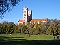
- The Church of St. Paul , built between 1892 and 1906, is located on Sankt-Pauls-Platz . The architect Georg von Hauberrisser created this impressive neo-Gothic basilica based on the Rhenish Gothic style .
- Between Thalkirchner Straße and Pestalozzistraße is the Old Southern Cemetery , which is no longer used as a cemetery and is a listed building and nature reserve.
- Between Landwehrstrasse, Schwanthalerstrasse and Sonnenstrasse, the German Theater in Munich is in the neo-baroque style .
- The Munich trade union building on Schwanthalerstraße is the house in which most of Munich's individual trade unions and the DGB Munich have their headquarters.
- The Bayerpost in a neo -constructions of the 1896th
- The Mathäser between Stachus and Hauptbahnhof was a popular beer bar for centuries and for a time in 1918 it was the headquarters of the Munich Soviet Republic . After severe damage in the Second World War, it was converted into a veritable “beer town” with 16 restaurants and one of the largest cinemas in Germany and since the new building (1999-2003) has housed a modern multiplex cinema center with 14 halls and several bars and shops as well as representative office space with roof terraces.
- The State Theater on Gärtnerplatz was opened in 1865 in the Isarvorstadt.
- In Hermann-Schmid-Straße there is a memorial that reminds of the location of the former Israelite hospital and nurses' home .
- The Roman Catholic Church of St. Maximilian was built from 1892 to 1908 according to plans by Heinrich von Schmidt in the neo-Romanesque style.
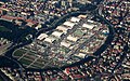
- The Theresienwiese is a square or a special open space with 42 hectares on which many events take place, including the world-famous Oktoberfest

St. Paul

St. Paul, interior

Munich Trade Union House

Old southern cemetery

Main building of the European Patent Office

German museum

German Theater Munich

Bayerpost

State Theater on Gärtnerplatz
St. Maximilian, seen from the Isar floodplain
Theresienwiese one day before the opening of the Oktoberfest 2006

"The Seven" on Müllerstrasse

Lindwurmhof


Architectural monuments
- List of architectural monuments in Munich / Isarvorstadt
- List of architectural monuments in Munich / Ludwigsvorstadt
statistics

(As of December 31, residents with main residence)
| year | Residents | including foreigners | Inhabitants per km² |
|---|---|---|---|
| 2000 | 44,451 | 14,301 (32.2%) | 10.131 |
| 2001 | 44,484 | 14,025 (31.5%) | 10.139 |
| 2002 | 44,059 | 13,684 (31.1%) | 10,042 |
| 2003 | 43,637 | 13,293 (30.5%) | 9,946 |
| 2004 | 43,469 | 12,793 (29.4%) | 9,908 |
| 2005 | 43,954 | 12,953 (29.5%) | 10,010 |
| 2006 | 45,736 | 12,797 (28.0%) | 10,414 |
| 2007 | 46,520 | 12,824 (27.6%) | 10,592 |
| 2008 | 47,599 | 13,042 (27.4%) | 10,814 |
| 2009 | 46,446 | 11,944 (25.7%) | 10,552 |
| 2010 | 47,357 | 12,255 (25.9%) | 10,759 |
| 2011 | 48.231 | 12,614 (26.2%) | 10,958 |
| 2012 | 49,657 | 13,604 (27.4%) | 11,282 |
| 2013 | 50,620 | 14,346 (28.3%) | 11,501 |
| 2014 | 52,177 | 15,778 (30.2%) | 11,855 |
| 2015 | 54,049 | 17,138 (31.7%) | 12,280 |
| 2016 | 54,915 | 17,912 (32.6%) | 12,477 |
| 2017 | 51,632 | 14,825 (28.7%) | 11,731 |
| 2018 | 51,644 | 14,654 (28.4%) | 11,734 |
| 2019 | 51,933 | 14,700 (28.3%) | 11,799 |
Source with further data
politics
The district committee of Ludwigsvorstadt-Isarvorstadt was last elected on March 15, 2020. Of the 38,525 residents in Ludwigsvorstadt-Isarvorstadt who are entitled to vote, 20,343 exercised their right to vote, bringing the voter turnout to 52.8% (2014: 41.0%). In the previous legislative period, the Greens and the Pink List formed a group of parliamentary groups and thus jointly achieved twelve seats. The constituent assembly on May 7, 2014 elected Alexander Miklosy (Pink List) as the district committee chairman. After Miklosy passed away in December 2018, Andreas Klose, also from the Pink List, was elected as his successor in March 2019. Miklosy had held the post for two decades.
In the constituent meeting on May 7, 2020, the board unanimously elected Benoît Blaser, the previous chairman of the Green / Pink List group, as the new district committee chairman. This is the first time that the body is chaired by a representative from Alliance 90 / Greens, who also has French citizenship in addition to German. Blaser's two deputies, Andreas Klose (Pink List) and Dr. Barbara Turczynski-Hartje (SPD) were each elected unanimously. The district committee has organized itself into four committees for future work: Culture, Youth, Social Affairs (Chair: Beate Bidjanbeg, SPD) - Planning and Building (Chair: Dr. Martin Ruckert, CSU) - Public Space and Mobility (Chair: Claudia Lowitz , Greens) - Environment, Climate, Local Recreation (Chair: Arne Brach, Greens).
- Composition of the district committee
| Political party | Green | SPD | CSU | Pink list | FDP | The left |
|---|---|---|---|---|---|---|
| 2020 | 11 | 4th | 4th | 2 | 2 | 2 |
| 2014 | 9 | 6th | 6th | 3 | 1 | |
| 2008 | 7th | 7th | 5 | 3 | 1 | |
| 2002 | 6th | 9 | 7th | 3 |
literature
- Martin Arz: Isarvorstadt: travel guide for Munich residents . Hirschkäfer, Munich 2012, ISBN 978-3-940839-28-2 .
- Martin Arz: The Isar suburb. Gärtnerplatz, Glockenbach and Schlachthof districts . Stag beetle, Munich 2008, ISBN 978-3-940839-00-8 .
- Christine Rädlinger : History of the Munich city streams . Ed .: City Archives Munich. Franz Schiermeier Verlag, Munich 2004, ISBN 3-9809147-2-0 .
Web links
- District Ludwigsvorstadt - state capital Munich
- District Isarvorstadt - state capital Munich
- City district and district committee 2 Ludwigsvorstadt-Isarvorstadt - State capital Munich
- District Committee website in District 2
Individual evidence
- ↑ Statistical Pocket Book 2020 (PDF). Statistical Office of the State Capital Munich. Retrieved August 24, 2020.
- ↑ Ferdinand Stracke: Location Munich - urban development in the 20th century . Franz Schiermeier Verlag, 2011, ISBN 978-3-9814521-2-9 , p. 292.
- ^ Archive district information . State capital Munich. Retrieved January 6, 2019.
- ↑ a b c Election of the District Committee - District 2 - Ludwigsvorstadt-Isarvorstadt . State capital Munich. Retrieved March 20, 2020.
- ↑ muenchen.info: The members of the district committee 2
- ↑ SZ: Friede, Freude, Eierkuchen, May 8, 2020
- ↑ Members of BA-2 in the Council Information System (RIS)
- ↑ District committee election 2020
- ↑ District committee election 2014
- ↑ District committee election 2008
- ↑ District committee election 2002

Allach-Untermenzing (23) | Altstadt-Lehel (1) | Au-Haidhausen (5) | Aubing-Lochhausen-Langwied (22) | Berg am Laim (14) | Bogenhausen (13) | Feldmoching-Hasenbergl (24) | Rags (20) | Laim (25) | Ludwigsvorstadt-Isarvorstadt (2) | Maxvorstadt (3) | Milbertshofen-Am Hart (11) | Moosach (10) | Neuhausen-Nymphenburg (9) | Obergiesing pheasant garden (17) | Pasing-Obermenzing (21) | Ramersdorf-Perlach (16) | Schwabing-Freimann (12) | Schwabing-West (4) | Schwanthalerhöhe (8) | Sendling (6) | Sendling-Westpark (7) | Thalkirchen-Obersendling-Forstenried-Fürstenried-Solln (19) | Trudering-Riem (15) | Untergiesing-Harlaching (18)