
Auenstrasse
| Auenstrasse | |
|---|---|
|
|
|
 |
|
| Auenstraße 86 (near Baldeplatz) | |
| Basic data | |
| State capital | Munich |
| Borough | Ludwigsvorstadt-Isarvorstadt |
| Name received | 1874 |
| Connecting roads | Erhardtstrasse, Ehrengutstrasse |
| Cross streets | Fraunhoferstraße , Pfarrer-Rosenberger-Straße, Baaderstraße, Deutingerstraße, Westermühlstraße, Klenzestraße, Körnerstraße, Arndtstraße, Baldestraße, Kapuzinerstraße , Geyerstraße, Wittelsbacherstraße, Hefner-Alteneck-Straße, Isartalstraße |
| Places | Baldeplatz |
| Numbering system | Orientation numbering |
| Buildings | St. Maximilian |
| use | |
| User groups | Pedestrian traffic , bicycle traffic , individual traffic , public transport |
| Road design | largely one-way street (direction out of town) |
| Technical specifications | |
| Street length | 1.3 km |
The Auenstraße is a city road in the Isarvorstadt in Munich Glockenbachviertel . It leads from Erhardtstrasse to Ehrengutstrasse.
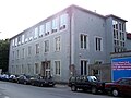
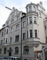
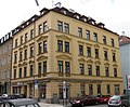
The parish church of St. Maximilian is located on it between Wittelsbacherstrasse and Auenstrasse. There are architectural monuments at Auenstrasse 1, 2 / 2a, 8, 10, 14, 23, 25/27, 31, 33, 37, 72, 84, 86, 88/90 and 98 (see also: List of architectural monuments in the Isarvorstadt ). In 2018, a commemorative sign for victims of the Nazi regime in Munich was attached to Therese Kühner's former apartment at Auenstrasse 15 . The former clubhouse of TSV 1860 Munich is located at Auenstrasse 19 and today houses the club's boxing department.

St. Maximilian
Auenstrasse 19
Auenstrasse 23

Auenstrasse 31

Auenstrasse 33
Auenstrasse 72

Auenstrasse 84

Auenstrasse 88


history
Auenstraße was named in 1876 after the floodplains on the left bank of the Isar in the Glockenbachviertel.
The old crushing and plague house for the seriously ill was located between Baumstrasse and Auenstrasse, between two city streams .
Web links
Individual evidence
- ^ Hans Dollinger: The Munich street names. 5th edition. Ludwig Verlag, Munich 2004, ISBN 3-7787-5174-3
- ↑ State capital Munich Editor: Therese Kuehner. Retrieved January 19, 2020 .
Coordinates: 48 ° 7 ′ 30.7 ″ N , 11 ° 34 ′ 11.5 ″ E