Feldmoching-Hasenbergl
|
Feldmoching-Hasenbergl
State capital Munich
Coordinates: 48 ° 12 ′ 40 ″ N , 11 ° 32 ′ 30 ″ E
|
|
|---|---|
| Area : | 28.94 km² |
| Residents : | 62,069 (Dec. 31, 2019) |
| Population density : | 2.145 inhabitants / km² |
| Postal code : | 80933, 80935, 80995 |
| Area code : | 089 |
|
Location of the city district 24 Feldmoching-Hasenbergl in Munich
|
|
Feldmoching-Hasenbergl is the city district 24 in the north of the Bavarian capital Munich .
District parts of the city district are Feldmoching , Lerchenau , Hasenbergl and Ludwigsfeld . The districts included are Fasanerie-Nord , Feldmochinger Anger , Harthof and Lerchenauer See .
location
The city district covers large areas of the north of Munich and lies in the flat Munich gravel plain . It extends from Dachauer Straße (B 304) in the west to Schleissheimer Straße in the east. The northernmost district of Munich extends from the DB marshalling yard Munich-North in the south to the city limits in the north. The Dreiseenplatte , the Panzerwiese and Hartelholz , the Oberschleißheim regatta course and the Allacher Lohe landscape lake are striking .
Neighboring districts are Milbertshofen-Am Hart in the east and southeast, Moosach in the south and Allach-Untermenzing in the west. In the northwest the district borders on the municipality of Karlsfeld , in the north on the municipality of Oberschleißheim .
Boroughs
Feldmoching
The largely agricultural Feldmoching is the largest and northernmost district in terms of area. 11,008 people live there [2015].
In it lies the Feldmochinger Anger green corridor , the Schwarzhölzl , the Feldmochinger See and parts of the Feldmochinger Mühlbach and the Regattaparksee . More than half of the district area is still used for agriculture, that is 1/5 of the total agricultural area of Munich.
Lerchenau East / Hasenbergl
The district of Lerchenau Ost / Hasenbergl consists of the Hasenbergl in the northeast of the district. The Hasenbergl stretches from the city limits at Hartelholz in the north to Harthof in the south and Schleißheimer Straße in the east. Feldmoching is separated to the west by the Feldmochinger Anger . Today (2015 depending on the source) 25,000 to 34,387 people live in the district.
To the south of Gundermanstrasse, the district becomes Lerchenau .
Ludwigsfeld
Ludwigsfeld is the most south-westerly sub-district. 3,395 people live there [2015]. It borders in the north and northeast on Feldmoching and in the east on Fasanerie-Nord in the Lerchenau West district. Ludwigsfeld borders Moosach to the south and the Allach-Untermenzing district to the west .
Lerchenau West
The district of Lerchenau West is located in the central southern part of the district and consists of the settlement on Lerchenauer See and the Fasanerie-Nord located further to the west . To the east lies the Lerchenauer See , behind which it borders the Lerchenau district . In the south lies the district border with the marshalling yard north, in the west it borders on the district Ludwigsfeld and in the north lies the Fasaneriesee , where the district part Feldmoching connects. 12,744 people live there [2015].
Architectural monuments
culture and education
- Institutions
- Cultural center 2411
- Local museum of the cultural and historical association
- Diakonie Hasenbergl
- Bright spot Hasenbergl
- Hasenbergl adventure playground - ABIX
- Blue point at Goldschmiedplatz
- Leisure center KistE, Gundermannstr. 77
- schools
In Feldmoching-Hasenbergl there is the Erich Kästner-Realschule , the Willy-Brandt-Gesamtschule Munich and the International Bilingual School Munich.
- Churches
In Feldmoching-Hasenbergl there are the Roman Catholic churches: St. Agnes , St. Johannes Evangelist , Mariä Siebenorben , St. Peter and Paul , St. Christoph , Alte St. Christoph-Kirche , St. Nikolaus , the Evangelical Lutheran churches: Kapernaumkirche , Bethanienkirche and Evangeliumskirche as well as the Russ. St. Michael Orthodox Church .
Sports
- Münchner SC , Eberwurzstrasse 28
- Sports club Munich Feldmoching, Grohmannstr. 63
- Regatta course Oberschleißheim
- FC Fasanerie Nord
Green spaces
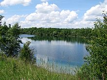
Feldmoching-Hasenbergl is characterized by numerous green areas. These include the lakes: Fasaneriesee , Feldmochinger See , Landschaftssee Allacher Lohe , Lerchenauer See , Regattaparksee , Oberschleißheim regatta course and the brooks: Feldmochinger Mühlbach and Schwabenbächl . Green areas and parks can be found at Krempelhuberplatz , Dülferanger , Feldmochinger Anger , Goldschmiedplatz and the green area on Schittgablerstraße . Of the flora and fauna, the amphibian biotope Fasanerie , the Eggarten settlement , the approx. 30 hectare green area south of the settlement on Lerchenauer See and the Virginia depot are particularly worthy of protection . In the north there is the Schwarzhölzl forest in the northeast the hardwood and the Panzerwiese . In addition, large areas of Feldmoching-Hasenbergl are still characterized by agricultural land.
Transport links
The Munich-Feldmoching train station is on the Munich – Regensburg railway line . The S-Bahn line S1 has been in Feldmoching since 1972 . On November 8, 1963, the tram was also extended from Scheidplatz to Harthof and on December 18, 1964 to Hasenbergl (final stop at Goldschmiedplatz ). On November 20, 1993, the extended U2 underground line finally came from Scheidplatz to Dülferstraße , and the tram to Hasenbergl was discontinued at the same time. On October 26, 1996, the U2 was again extended by two stations via the Hasenbergl to the S-Bahn in Feldmoching. Since, in addition to the S-Bahn to Freising / airport , regional trains from Landshut also stop regularly - albeit very rarely - at Feldmoching station, this is one of the most important transfer stations in the network of the Munich Transport and Tariff Association (MVV) after the extension of the underground .
Remnants of the tram tracks can still be seen in many places today. B. in the former Wendeschleife at Goldschmiedplatz. The current traffic development plan of the state capital Munich includes the option to extend the currently under construction tram line 23 from Parkstadt Schwabing via the Euro-Industriepark and Neuherbergstrasse back to Goldschmiedplatz. This measure is planned to be implemented by 2015, but so far without secured funding.
Since 2016, a pedestrian and cycle path underpass under the northern ring of the railway between Wilhelmine-Reichard-Straße and Am Oberwiesenfeld has connected southern Lerchenau with the U3 Oberwiesenfeld .
statistics

(As of December 31, residents with main residence)
| year | Residents | including foreigners | Inhabitants per km² |
|---|---|---|---|
| 2000 | 52,407 | 13,073 (24.9%) | 1,825 |
| 2001 | 52,896 | 13,240 (25.0%) | 1,842 |
| 2002 | 53,010 | 13,338 (25.2%) | 1,846 |
| 2003 | 52,961 | 13,385 (25.3%) | 1,845 |
| 2004 | 52,958 | 13,420 (25.3%) | 1,845 |
| 2005 | 53,389 | 13,832 (25.9%) | 1,860 |
| 2006 | 54,245 | 13,927 (25.7%) | 1,889 |
| 2007 | 55,475 | 14,642 (26.4%) | 1.932 |
| 2008 | 55,667 | 14,780 (26.6%) | 1,940 |
| 2009 | 55,180 | 14,265 (25.9%) | 1,907 |
| 2010 | 56,130 | 15,015 (26.8%) | 1,940 |
| 2011 | 57,183 | 15,689 (27.4%) | 1,976 |
| 2012 | 58,245 | 15,689 (27.4%) | 2.013 |
| 2013 | 59,391 | 17,522 (29.5%) | 2,052 |
| 2014 | 60,262 | 18,347 (30.4%) | 2,082 |
| 2015 | 61,534 | 19,543 (31.8%) | 2.126 |
| 2016 | 61,764 | 19,807 (32.1%) | 2.134 |
| 2017 | 60,933 | 19,296 (31.7%) | 2,106 |
| 2018 | 61,774 | 20,037 (32.4%) | 2.135 |
| 2019 | 62,069 | 20,352 (32.8%) | 2.145 |
Source with further data
politics
The district committee of Feldmoching-Hasenbergl was last elected on March 15, 2020. The distribution of seats is as follows: CSU 8, Greens 6, SPD 5, Munich List 3, FW / ÖDP 2, AfD 2 and FDP 1. Of the 40,806 residents in Feldmoching-Hasenbergl who are entitled to vote, 17,144 have exercised their right to vote Turnout was 42.0 percent.
Urban development
Due to the expected population growth in Munich , possible urban development areas, especially on the outskirts, are being sought. Individual agricultural areas around Feldmoching are being expanded: For example, the 23.8 hectare Lerchenauer Feld in the south between Lerchenauer - and Lerchenstrasse or the 8.4 hectare area on Hochmuttinger Strasse north of Herbergstrasse. A former settlement, the Eggarten settlement , south of Lake Lerchenau, is also being built up more densely.
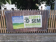
Furthermore, the city of Munich has plans to expand the entire undeveloped, 900-hectare area in the city district between Feldmoching , Ludwigsfeld and up to the A99 motorway. The project originally started under the name Urban Development Measure Munich North ( SEM ) was discontinued in 2018 for the Feldmoching-Hasenbergl district. However, it is now being changed as a cooperative urban development model Feldmoching - Ludwigsfeld ( KOSMO ). A feasibility study should be available by 2023, and then further planning will be carried out by 2029.
The concept of urban development measures in Munich North also provided for the expropriations of the landowners. This has given rise to citizens' initiatives, both against and for the project. The HEIMATBODEN Munich initiative is made up of residents, agricultural landowners and representatives of the growth-critical voter group Munich List . She advocates a socially just land use procedure (SoBoN). The Munich process of socially just land use (SoBoN) is a process introduced by the Munich city council. It does not expropriate the landowners, but shares them with the follow-up costs of the planning .
The PROSEM supports the project of the City of Munich and is made up of housing associations, tenants 'organizations, social organizations such as the DGB Munich , the workers' welfare as the two Altoberbürgermeistern Munich and individuals Hans-Jochen Vogel and Christian Ude together.
Sons and Daughters of the Borough
- Willy Astor , cabaret artist
- Manfred Berger , educator
- Ursula Buchfellner , actress
- Mario Daser , boxer
- Günther Kaufmann , actor
- Daniel Bierofka , soccer player
- Andreas Ottl , soccer player
- Walter Sedlmayr , Bavarian folk actor
- Gerhard Sterr , band leader of the band Hot Dogs and artist.
- Otto Steiner , television producer
- Christine Zierl , actress
- Akilnathan Logeswaran , political activist
See also
literature
- Volker D. Laturell : Feldmoching - The origin and development history of a Munich district. Benno Tins, Munich 1970.
- Volker D. Laturell: Feldmoching-Hasenbergl - the district book for the 24th district with the districts Eggarten, Fasanerie, Feldmoching, Harthof, Hasenbergl, Lerchenau, Siedlung am Lerchenauer See and Ludwigsfeld (with contributions by Reinhard Bauer ). Bavarica-Verlag Bauer, Munich 2000, ISBN 3-935440-01-4 .
- Helmuth Stahleder : From Allach to Zamilapark. Names and basic historical data on the history of Munich and its incorporated suburbs . Ed .: City Archives Munich. Buchendorfer Verlag, Munich 2001, ISBN 3-934036-46-5 .
- Otto Steiner: Foray of a pastor and contemporary on the Hasenbergl . JP Peter, Rothenburg ob der Tauber 1987, ISBN 3-87625-005-6 .
Web links
- Feldmoching district - state capital Munich
- District Hasenbergl - state capital Munich
- City district and district committee 24 Feldmoching-Hasenbergl - City of Munich
- Br.de: 50 years of Hasenbergl
- Feldmoching-Hasenbergl Culture and History Trail
Individual evidence
- ↑ Current years (PDF). Retrieved February 22, 2020.
- ↑ https://www.citypopulation.de/php/germany-munchen_d.php
- ↑ https://www.feldmoching.com/index.php/de/feldmoching/geschichte-feldmochings?start=3
- ↑ https://www.br.de/br-fernsehen/sendung/ Zwischen-spessart-und-karwendel/50-jahre-hasenbergl- 100.html
- ↑ https://www.citypopulation.de/php/germany-munchen_d.php
- ↑ https://www.citypopulation.de/php/germany-munchen_d.php
- ↑ https://www.citypopulation.de/php/germany-munchen_d.php
- ↑ Timetable of the subway openings in Munich
- ↑ Transport development plan of the city of Munich (PDF)
- ↑ merkur.de
- ↑ sueddeutsche.de
- ^ Archive district information . State capital Munich. Retrieved January 6, 2019.
- ↑ a b c Election of the District Committee - District 24 - Feldmoching-Hasenbergl . State capital Munich. Retrieved May 1, 2020.
- ↑ muenchen.de - Lerchenauer Strasse
- ↑ muenchen.de - Quarter on Hochmuttinger Strasse
- ↑ muenchen.de - urban development in Feldmoching - Ludwigsfeld
- ↑ sueddeutsche.de - Can the north of Munich tolerate a new settlement area?
- ↑ heimatboden-muenchen.de
- ↑ muenchen.de - Munich process of socially just land use
- ↑ Socially just land use (SoBoN) - a Munich way
- ↑ prosem-muenchen.de - alliance partner


