Sendling West Park
|
Sendling West Park
State capital Munich
Coordinates: 48 ° 7 ′ 20 ″ N , 11 ° 31 ′ 55 ″ E
|
|
|---|---|
| Area : | 7.81 km² |
| Residents : | 60,498 (Dec. 31, 2019) |
| Population density : | 7.742 inhabitants / km² |
| Postcodes : | 80686, 81369, 81373, 81377, 81379 |
| Area code : | 089 |
|
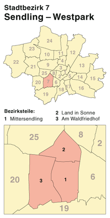
Location of the city district 7 Sendling-Westpark in Munich
|
|
|
Luise-Kiesselbach-Platz, the above-ground traffic junction above the road tunnel of the Middle Ring
|
|
Sendling-Westpark is the city district 7 of the Bavarian capital Munich .
location
The city district 7 is located in the southwest of Munich and extends in the north-south expansion from the city district 8 Schwanthalerhöhe to Obersendling (city district 19 Thalkirchen-Obersendling-Forstenried-Fürstenried-Solln ). The railway body of the Munich – Holzkirchen railway line forms the eastern border . Beyond the tracks, the district 6 adjoins Sendling , in the west the district ends on Fürstenriederstrasse and Westendstrasse, beyond which the districts 20 Hadern and 25 Laim are located.
description
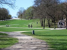
The city district was not created until the district reform in 1992 from most of the disbanded Waldfriedhofviertel district, with the Waldfriedhof itself being assigned to Hadern . Furthermore, minor border corrections were made with the neighboring districts of Sendling and Laim. It was named after the shares in Sendling and the Westpark , which was created for the International Horticultural Exhibition in 1983 and is now the largest green space in the district.
The areas of today's Sendling-Westpark were mostly built after World War II, from 1950 to 1995, the population has doubled since continues to find above-average growth of the population instead. The population composition was somewhat older than the average up to the turn of the millennium, the proportion of foreigners was slightly below the city average. Since then, there has been a rejuvenation, so that Sendling-Westpark is now average according to gender and age; however, the newcomers are more often not German citizens. Typical of the building structure of the district are single and two-family houses from the interwar period in the southern part and apartment buildings in the area of the main roads, mostly from the period after 1948.
The district is traversed by several main roads, with the section of the Mittlerer Ring running right through the quarter with the ends of the A 96 (Munich– Lindau ) and A 95 (Munich– Garmisch ) causing high traffic and environmental pollution. The opening of the Mittlerer Ring road tunnels at Luise-Kiesselbach-Platz and Heckenstallerstraße in the summer of 2015 will help to ease the burden.
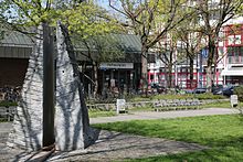
As a high-performance public transport system, the underground is represented by three stations on the U6 line, which runs east-west. The stations Partnachplatz , Underground Station Westpark and Holzapfelkreuth were in 1983 as a so-called flower line opened to IGA. The Partnachplatz was redesigned after the opening of the underground station and since then shows a fountain by the sculptor Alfred Görig , which represents the Partnach Gorge , which gives the place its name, through two rock slabs over a narrow watercourse .

At the same time, the district has a large and well-distributed proportion of green spaces. In addition to the eponymous Westpark , this includes a large part of the Sendlinger Forest and the allotment garden “Land in Sonne”, which also gives its name to a part of the district, as well as the sports areas of two district sports facilities and several smaller district parks. In the course of the tunnel construction projects, the Heckenstallerpark and the redesign of the Luise-Kiesselbach-Platz were added to the urban district by 2017 .
In the north-west of the city district there are various educational institutions on the former site of the Neufriedenheim sanatorium , including the two only grammar schools in the district: the Ludwigsgymnasium and the Erasmus-Grasser-Gymnasium . A further expansion to the Westpark educational campus is being planned. There are also two primary schools and one secondary school in Sendling-Westpark. These include two Greek schools which teach according to the Greek curriculum and in the Greek language.
The Rudi-Sedlmayer-Halle , located in the northern part of the Westpark , in which numerous cultural and sporting events previously took place, was closed from 2003 to 2011 and has since been the venue for FC Bayern basketball players under the name Audi Dome . In addition, the youth culture center of Feierwerk is located in the city district on a former industrial site on Hansastraße, with a city-wide catchment area.
history
The corridor of today's Sendling-Westpark originally belonged to Sendlinger Haide, which stretched between Forstenrieder Park and the city of Munich. Before the Second World War, there were only a few building areas in what is now the city district, which grew from the neighboring settlement centers into the agriculturally used areas.
Before 1900
The beginning of the settlement of the later city district are all just outside of today's borders. These include the Neolithic graves (2000 BC) and the Celtic graves on the edge of the Isar slope at that time, which are assigned to the Sentilo clan , who is considered to be the namesake of Sendling.
It was not until the 17th century that Mittersendling developed with two noble seats ( Hofmarken ) directly on the eastern border of today's Sendling-Westpark: Neuhofen and the Castellhof zu Sendling. The church of St. Dionys (today St. Achaz ) was also located in Mittersendling . Within the current boundaries of today's Sendling-Westpark were agricultural areas and forests that were cultivated by these settlements. In 1760, only one property on Sendlinger Haide was taxable.
That only changed slowly after the construction of the Maximiliansbahn, the railway line from Munich to Holzkirchen , the section of which here began operation in 1845 and which was completed by 1857.
20th century
As in all of Munich, the settlements in the south-west were expanded during the so-called Prince Regent Period around the turn of the 20th century. In the north-west of today's area, the then still remote sanatorium Neufriedenheim was built, south of it the excursion restaurant Holzapfelkreuth was built . Shortly after the turn of the century, the forest cemetery was created, which is now just outside the district, but has had a strong impact on the structural development of the southwestern district. It was also during this period that an industrial park was built on Hansastrasse, starting from the Westend and the freight yard at today's Heimeranplatz . After the First World War, war invalids built the war settlement , which is now protected as a monument ensemble. In the vicinity of the central intersection of the district, the St. Josef retirement home was built in the 1920s by the architect Hans Grässel , with its own church and striking towers. From 1935 to 1938, the Oberland housing estate was built at the beginning of the Olympia-Strasse (now A95 ) laid out for the 1936 Winter Olympics in Garmisch-Partenkirchen . The plans came from the young architects Franz and Sep Ruf and Hans Holzbauer .
After the Second World War, as part of the reconstruction and for the settlement of displaced persons, large-scale facilities in the simplest of construction were built by urban housing associations and several simple or more upscale single-family housing estates. The most prominent resident was Franz Josef Strauss , who lived in what is now Sendling-Westpark from 1978 until his death in 1988. In the following decades, the areas between the houses, which had previously been concentrated mainly on the traffic axes, were built on. Large commercial areas were created on Albert-Rosshaupter-Strasse and Westendstrasse .
In the 1980s, two of the last large social housing estates were built in Sendling-Westpark. The settlement on Gottfried-Böhm-Ring and the Landaubogen (formerly Leonhard-Moll-Bogen).

Recent development
After the turn of the millennium, there was an increased densification and conversion of commercial space into residential space. The latter is the determining factor in the development of the district, but takes place on a smaller scale than in neighboring Obersendling . The particularly simple apartment blocks of the post-war period are either being renovated and partially expanded, or they are being demolished and rebuilt.
The city politicians feared that after the tunnel construction, the simple residential areas of the city district would be extensively renovated and rented at significantly higher prices. In order to avoid displacement of the established tenants, the city council issued a conservation statute for a contiguous area within the middle ring along Hansastraße and Albert-Rohßhaupter-Straße in January 2016 against the votes of the CSU, FDP, pirates and the Alfa group .
Administration, economy, other institutions
The responsible police station 15 is in Treffauerstraße. The criminal specialist department 1 of the Munich police headquarters is also located in the city district . The police station K11, the Munich homicide squad, belongs to him.
In addition to the professional fire brigade, the Sendling department of the Munich volunteer fire brigade, whose fire station is located on Zillertalstrasse, is also responsible for security in Sendling-Westpark.
Important employers and institutions in the district are the St. Josef municipal old people's home , the Lebenshilfe workshop for the disabled, the ICP integration center for cerebral palsy with a rehabilitation school and vocational training center, the headquarters of ADAC and TÜV Süd , and since 2003 the central administration of the Fraunhofer Society and the motor vehicle - Registration office, the bakeries Hofpfisterei and Vinzenz Zöttl and the lost property office of the city. In addition, construction companies and metal processing companies provide a large proportion of the jobs, with iwis for the manufacture of precision chains and mechanical drive technology for the automotive industry as the largest employer in the district.
There are several large-scale sports facilities in the district, including the basketball hall (now the Audi Dome ) built for the 1972 Summer Olympics , in which the FC Bayern Munich basketball team plays. In addition, the Royal Privileged Hauptschützengesellschaft and the Rot-Weiß München association have their headquarters and facilities in Sendling-Westpark.
Architectural monuments
Due to the late development of the city district and the predominantly simple development, there are only a few architectural monuments in Sendling-Westpark. Since 2000, several of the churches that were built in the course of the reconstruction with the residential development after 1945 have been placed under monument protection.
List of architectural monuments in Munich / Sendling-Westpark
politics
The district committee of Sendling-Westpark was last elected on March 15, 2020. The distribution of seats is as follows: CSU 7, SPD 6, Greens 10, Free Voters 2, Linke 1 and FDP 1. Of the 43,164 residents in Sendling-Westpark who are entitled to vote, 20,878 have exercised their right to vote, making the turnout 48.4 percent lay.
statistics

(As of December 31, residents with main residence)
| year | Residents | including foreigners | Inhabitants per km² |
|---|---|---|---|
| 2000 | 48,388 | 10,724 (22.2%) | 6,193 |
| 2001 | 48,608 | 10,846 (22.3%) | 6.221 |
| 2002 | 48,448 | 10,781 (22.3%) | 6,201 |
| 2003 | 48,564 | 11,020 (22.7%) | 6.216 |
| 2004 | 48,669 | 11,127 (22.9%) | 6.228 |
| 2005 | 49,472 | 11,492 (23.2%) | 6.330 |
| 2006 | 50.903 | 11,746 (23.1%) | 6,514 |
| 2007 | 51,745 | 11,830 (22.9%) | 6,622 |
| 2008 | 52,257 | 12,011 (23.0%) | 6,687 |
| 2009 | 52.185 | 11,825 (22.7%) | 6,678 |
| 2010 | 52,495 | 12,220 (23.3%) | 6,718 |
| 2011 | 53,271 | 12,907 (24.2%) | 6,817 |
| 2012 | 54,552 | 13,829 (25.4%) | 6,981 |
| 2013 | 55.405 | 14,445 (26.1%) | 7,090 |
| 2014 | 56,485 | 15,354 (27.2%) | 7,228 |
| 2015 | 58,398 | 16,625 (28.5%) | 7,473 |
| 2016 | 59,175 | 17,026 (28.8%) | 7,572 |
| 2017 | 59,386 | 16,888 (28.4%) | 7,599 |
| 2018 | 59,643 | 17,215 (28.9%) | 7,632 |
| 2019 | 60,498 | 17,817 (29.5%) | 7,742 |
Source with further data
Web links
- Sendling-Westpark district - City of Munich
- City district and district committee 7 Sendling-Westpark - City of Munich
Individual evidence
- ↑ Statistical Pocket Book 2020 (PDF). Statistical Office of the State Capital Munich. Retrieved August 24, 2020.
- ↑ Alfred Görig. Biography and exhibitions. Retrieved October 7, 2019 .
- ^ Bavarian State Ministry for Culture: Private Greek Elementary School Munich
- ^ Monika Müller-Rieger: Westend - From the Sendlinger Haid 'to the Munich district . Buchendorfer Verlag, 2000, ISBN 3-927984-29-9 , p. 11.
- ↑ Süddeutsche Zeitung: Protection for tenants , January 27, 2016
- ^ Resolution of the statutes of the “Sendling-Westpark” conservation statute. (PDF; 546 kB) In: City of Munich, Department for Urban Planning and Building Regulations. January 16, 2016, accessed on October 5, 2019 (with a map for the coverage of the statutory area).
- ↑ Bavarian Police: Presidium Munich - Criminal Specialist Department 1
- ↑ Sendling volunteer fire brigade (official website)
- ↑ a b c Election of the district committee - District 7 - Sendling-Westpark . State capital Munich. Retrieved April 6, 2020.
- ^ Archive district information . State capital Munich. Retrieved January 6, 2019.


