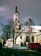
Lindwurmstrasse
| Lindwurmstrasse | |
|---|---|
| Street in Munich | |
| View into town at the height of Zenettistrasse | |
| Basic data | |
| State capital | Munich |
| Borough | Ludwigsvorstadt-Isarvorstadt , Sendling |
| Created | before 1372 |
| Hist. Names | Sendlinger Weg, Sendlinger Landstrasse, Sendlinger Hauptstrasse |
| Name received | 1878 |
| Connecting roads | Sendlinger-Tor-Platz , Plinganserstraße |
| Cross streets | Sonnenstrasse , Blumenstrasse , Fly Street, Augsburgerstrasse, Reisingerstrasse, Ziemssenstrasse, Rothmundstrasse, Ringseisstrasse, Häberlstrasse, Goethestrasse , Kapuzinerstrasse , Herzog-Heinrich-Strasse, Hermann-Schmid-Strasse, Zenettistrasse, Stielerstrasse, Schmellerstrasse, Güllstrasse, Ruppertstrasse, Pocplerstrasse, Implerstrasse Aberlestrasse, Bavariastrasse, Daiserstrasse, Kidlerstrasse |
| Places | Sendlinger-Tor-Platz , Goetheplatz |
| Numbering system | Orientation numbering |
| Buildings | St. Matthäus , University of Munich Clinic , Dr. von Haunersches Children's Hospital , St. Margaret |
| Subway station | Underground station Sendlinger Tor , goetheplatz , Metro Station Poccistraße |
| use | |
| User groups | Pedestrian traffic , bicycle traffic , car traffic , public transport |
| Road design | Poplar Avenue |
| Technical specifications | |
| Street length | 2.4 km |
The Lindwurmstraße is a 2.4 km long poplar avenue in Munich districts Ludwig-Isarvorstadt and Sendling .
Location and course
The Lindwurmstrasse runs one kilometer northwest parallel to the Isar and mostly flat at an altitude of about 520 m above sea level. NN from Sendlinger Tor in a south-westerly direction. Between the Poccistraße and Implerstraße they pass under a subway to Munich South Ring , a railway line, the south of the center of the Munich East train station to the Munich Central Station and the rail yard Laim combines. Only shortly before its southern end in Munich- Sendling does it rise on Pfeuferstrasse to 534 m above sea level. NN to.
Well-known residents are u. a. the hospital of the University of Munich , the Haunersche Children's Hospital and the churches of St. Matthew and St. Margaret .
history
The Bavarian original cadastre shows Lindwurmstraße in the 1810s as a then unnamed road , which with a deciduous tree that was planned on both sides leads past Burgfriedstein No. 2 to Untersendling . In the 1860s it was crossed by the railway line and to the north-east of it a nameless street village emerged on its course .
It was formerly called Sendlinger Landstrasse. The "old road to Sendling" was renamed in 1878 after the doctor Joseph von Lindwurm (1824–1874, dermatologist and chief physician).
House no. 127 (then 125), now a branch of the Munich Adult Education Center , served the Jewish community as emergency accommodation because the National Socialists had the synagogue and community building on Herzog-Max-Strasse demolished. In 1941 there were deportations.
Until 1975 tram lines ran through Lindwurmstraße, which were discontinued after the underground railway was extended from Goetheplatz to Harras .
Today, Lindwurmstrasse is part of the Ludwigsvorstadt-Isarvorstadt cultural history trail .
Architectural monuments
Numerous buildings along Lindwurmstrasse are protected as architectural monuments, for example:
- Lindwurmstrasse 2a, II. Gynecological clinic of the university , neo-baroque building from 1915/16
- Lindwurmstrasse 4, Haunersches Children's Hospital , classifying from 1923/24
- Lindwurmstrasse 6, part of the post office on Goetheplatz from 1931/32
- Lindwurmstrasse 46, post-classicist tenement from 1911 above Kern from 1886
- Lindwurmstrasse 76 , stately office building, an Art Nouveau corner building from 1911/12
- Lindwurmstraße 88, Lindwurmhof , a monumental Art Nouveau commercial building from 1910/11
- Lindwurmstrasse 205 , tenement house, built in 1897 (German Renaissance)
- See also
- List of architectural monuments in Ludwigsvorstadt
- List of architectural monuments in the Isarvorstadt
- List of architectural monuments in Sendling
Works of art
- Baumzeichen 2, 7.2 m high bronze sculpture by Karl Jakob Schwalbach in front of the district administration department
- Schmied-von-Kochel monument by architect Carl Sattler and sculptor Carl Ebbinghaus (1906–1911), diagonally across from the Old Sendlinger Church
traffic
Lindwurmstraße has been expanded to four lanes for road traffic and has designated cycle paths in both directions, lined with tall poplars.
The public transport opens up the road at the metro station Sendlinger Tor , Goetheplatz and Poccistraße with lines U3 and U6 . The bus routes 62 and 132 as well as the night bus routes N 40, N 41 and N 45 also operate there on partial routes .
Web links
Individual evidence
- ^ A b Hans Dollinger: The Munich street names. 5th edition. Ludwig Verlag, Munich 2004, ISBN 3-7787-5174-3
- ^ Press report Süddeutsche Zeitung to Lindwurmstrasse
- ↑ Lindwurmstrasse on BayernAtlas Klassik around 1810
- ↑ old road to Sendling on BayernAtlas Klassik in the 1860s
- ↑ KulturGeschichtsPfad München.de (.pdf)
- ↑ LfD list for Munich (.pdf)
- ^ Tree Sign 2 - Schwalbach Karl Jakob
Coordinates: 48 ° 7 ′ 26.8 ″ N , 11 ° 32 ′ 53.3 ″ E


