
Sonnenstrasse (Munich)
| Sonnenstrasse | |
|---|---|
|
|
|
.JPG) |
|
| The Herzogspitalstrasse joins the Sonnenstrasse | |
| Basic data | |
| State capital | Munich |
| Townships | Altstadt-Lehel , Ludwigsvorstadt-Isarvorstadt |
| Name received | 1812 |
| Connecting roads | Stachus (Karlsplatz), Blumenstrasse |
| Cross streets | Bayerstraße , Schlosserstraße, Adolf-Kolping-Straße, Herzogspitalstraße, Schwanthalerstraße , Josephspitalstraße, Landwehrstraße |
| Places | Stachus (Karlsplatz), Sendlinger-Tor-Platz |
| Numbering system | Orientation numbering |
| Underground train stations (S- and U-Bahn) | Munich Karlsplatz station (main S-Bahn line , U4 , U5 ), Sendlinger Tor underground station ( U1 , U2 , U3 , U6 , U7 , U8 ) |
| use | |
| User groups | Pedestrian traffic , bicycle traffic , individual traffic , public transport |
| Road design | separate lanes, green central reservation with tram tracks |
| Technical specifications | |
| Street length | 600 m |
The Sun Road is a street in the city center of Munich . It forms the border between the old town and Ludwigsvorstadt districts .
description
Sonnenstrasse is part of Munich's Altstadtring and runs in a north-south direction between Sendlinger-Tor-Platz and Stachus . The wide street has up to eight lanes and in the middle a four-track route for the Munich tram .
Numerous clubs such as the Harry Klein techno club can be found along the approximately 600 meter long street . As a “party mile”, it connects Maximiliansplatz with the Glockenbachviertel . Due to the curved course of the road, it is also known colloquially as the "celebration banana".
history
The early modern fortifications of Munich ran along Sonnenstrasse . It received its current name in 1812 because its course is aligned with the highest position of the sun at noon.
The western Stadtgrabenbach runs underground parallel to Sonnenstrasse (near Herzog-Wilhelm-Strasse) ; it is fed by the Glockenbach near the Sendlinger Tor and follows the former city fortifications to the north and later northeast. There are plans to partially expose it again.
The Matthäuskirche , built in 1833 , the first Protestant church in Munich, stood on Sonnenstraße until it was demolished in 1938, at the confluence with Herzogspitalstraße.
In 1846 August Hauner founded the Dr. von Haunersche Children's Hospital , which is now located on Lindwurmstrasse . In 1856 the Frauengebäranstalt was completed on Sonnenstrasse , the first building in the Maximilian style by the architect Georg Friedrich Christian Bürklein ; from 1922 it was the post office, today the Isarpost event location . On the sunny street, the Hotel Wagner, which was the music hall cabaret Vienna-Munich and from 1934 to 1935 the Valentin panopticon was.
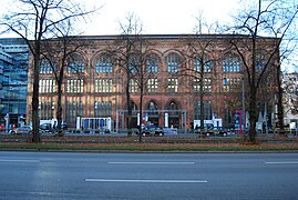
Isarpost, Sonnenstrasse 26

Department store Kaufhof

Sonnenstrasse, circa 1870
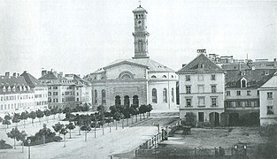
Matthew Church, circa 1865


Web links
Individual evidence
- ↑ http://prinz.de/muenchen/artikel/61942-sonnenstrasse-die-neue-partymeile/
- ^ Crime scene of the Banana Party. In: sueddeutsche.de. October 21, 2012, accessed June 23, 2018 .
- ^ Hans Dollinger: The Munich street names. 5th edition. Ludwig Verlag, Munich 2004, ISBN 3-7787-5174-3 , p. 282.
- ↑ http://www.tz.de/muenchen/stadt/gruene-wollen-muenchen-klein-venedig-machen-5519519.html
- ↑ http://gruene-fraktion-muenchen.de/munchner-stadtbache-beleben-freilegen-und-zuganglich-machen
Coordinates: 48 ° 8 ′ 12.1 ″ N , 11 ° 33 ′ 55.1 ″ E