
Altstadtring (Munich)
The Altstadtring in Munich is the innermost ring road there . With the exception of the northwest and northeast sections, it runs roughly along the former second city wall and encloses Munich's old town . With the exception of the section between Isartor and Sendlinger Tor (Blumenstrasse and Frauenstrasse), it has four or five lanes throughout.
Due to the loop solution, motorized traffic cannot cross the old town, so they have to drive around the old town on the old town ring. The ring was only broken through the old town or led over existing streets after the Second World War; despite some representative buildings, no boulevard was created around the former city wall in Munich .
Course of the road
The course of the road is described in a clockwise direction, starting in the north with the Altstadtringtunnel running under Ludwigstrasse .
Altstadtringtunnel
48 ° 8 ′ 41 ″ N , 11 ° 34 ′ 54 ″ E
The Altstadtringtunnel begins west of Ludwigstrasse , at the intersection of Oskar-von-Miller-Ring and Gabelsbergerstrasse . Traffic flows in three lanes in an easterly direction, the two-lane main tunnel leads to Prinzregentenstrasse in an easterly direction, the single-lane side arm follows the Altstadtring and, at the level of the State Chancellery, joins the Franz-Josef-Strauss-Ring and then on to the Karl-Scharnagl-Ring on. The tunnel runs in two or three lanes to the west. A single lane driveway from Von-der-Tann-Straße allows access from the Altstadtring. The main tunnel has a length of 610 m.
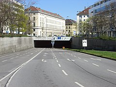
Tunnel portal at Oskar-von-Miller-Ring

Tunnel portal in Prinzregentenstrasse

Tunnel entrance in Von-der-Tann-Straße

Tunnel exit into Franz-Josef-Strauss-Ring
.jpg)
.jpg)
.jpg)
.jpg)
Von-der-Tann-Straße - Franz-Josef-Strauss-Ring - Karl-Scharnagl-Ring
48 ° 8 ′ 32 " N , 11 ° 35 ′ 1" E
Above ground, the Ring crosses Ludwigstrasse as Von-der-Tann-Strasse and Koeniginstrasse , which is closed to traffic and where the US Consulate General in Munich is located. Then the Prinzregentenstrasse is crossed in the form of an ascent or descent. Behind the Prinz-Carl-Palais (Königinstraße 1, official seat of the Bavarian Prime Minister) the street turns south and turns into the Franz-Josef-Strauss-Ring, at number 1 of which the Bavarian State Chancellery is located. From the confluence of Hofgartenstrasse, where the headquarters of the Max Planck Society is located, it runs as Karl-Scharnagl-Ring in a south-easterly direction to the breakthrough at what is now the intersection with Maximilianstrasse . The Altstadtring is almost entirely four-lane on this section.

Franz-Josef-Strauss-Ring: in the back the US Consulate General, on the left the Prinz-Carl-Palais

Karl-Scharnagl-Ring heading south before the Maximilianstrasse intersection
Karl-Scharnagl-Ring to the north at the confluence with Bürkleinstaße

Drive north on Karl-Scharnagl-Ring with the Bavarian State Chancellery at Franz-Josef-Strauss-Ring
.jpg)
.jpg)
.jpg)
.jpg)
Thomas-Wimmer-Ring - Isartorplatz - Frauenstrasse - Blumenstrasse
48 ° 8 ′ 5 " N , 11 ° 34 ′ 32" E
The Thomas-Wimmer-Ring leads to Isartorplatz , where Zweibrückenstraße branches off to the southeast, which in its extension as Rosenheimer Straße forms another important traffic axis. To the northwest, the wide “ Tal ” road opens up the old town from the Isar side. The Frauenstrasse and partly also the Blumenstrasse have only two lanes for reasons of space, which leads to regular traffic jams on this section of the ring. The Viktualienmarkt and the Schrannenhalle, which was rebuilt in 2003, can be found on Frauenstrasse .

Thomas-Wimmer-Ring: in front of the Isartor

Frauenstrasse: at the Viktualienmarkt

Blumenstrasse: on the left the Schrannenhalle, in the background the Viktualienmarkt

Blumenstrasse: cornering through the existing development
.jpg)
.jpg)
.jpg)
.jpg)
.jpg)
Sendlinger-Tor-Platz - Sonnenstrasse - Karlsplatz
48 ° 8 ′ 11 " N , 11 ° 33 ′ 54" E
Finally, Blumenstrasse reaches Sendlinger-Tor-Platz , where it crosses Lindwurmstrasse , an important traffic axis for the south-western suburb, and continues as Sonnenstrasse . The construction of this section required a major change in the cityscape, as the Sonnenstrasse is partly expanded to eight lanes due to the large volume of traffic and a four-lane tram line runs in the middle of the street. The Karlsplatz , popularly known as "Stachus", was long one of the busiest squares in Europe, to the eastern part of the square was transformed into a pedestrian zone.
A possible underground continuation of the straight lanes of the ring under the square and instead of parts of the current barrier level in the access structure to the underground and suburban railway did not materialize, the decision was made in favor of a shopping center.
At the northern end of Karlsplatz, Elisenstraße branches off to the west, which provides transport to the nearby Munich Central Station . The Altstadtring continues on its way to the northeast.
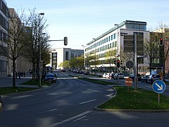
Lenbachplatz - Maximiliansplatz - Oskar-von-Miller-Ring
48 ° 8 ′ 33 " N , 11 ° 34 ′ 23" E
The Lenbachplatz embossed on its western side by some of the most magnificent buildings in the neo-baroque in Munich. The Neue Börse , the Bernheimer Palais and the two following buildings form an ensemble that was built shortly before 1900. In the north, the Wittelsbacher Brunnen closes the square. It was created in 1895 by the sculptor Adolf von Hildebrand to celebrate the completion of Munich's first water supply.
At Maximiliansplatz the Altstadtring runs with separate lanes, in between there is a small park with several monumental statues and fountains. Approximately in the middle, the square is crossed by a street that leads through the Maxtor into the old town. At the northern end of the square, the Altstadtring crosses Brienner Strasse , one of Munich's four boulevards. It then continues on its way as Oskar-von-Miller-Ring and reaches the Altstadtringtunnel.

Lenbachplatz with Stachus and Palace of Justice in the background

Maximiliansplatz: this is a traffic island between the directional lanes
.jpg)
.jpg)
Building history
The Munich Altstadtring had been planned since the 1940s and increasingly since the mid- 1960s . In 1966, many citizens resisted the plan to move the Altstadtring under the Prinz-Carl-Palais into a tunnel. The center of the protest was the citizens' initiative “Münchner Bauforum” . The construction of the tunnel could not be prevented, but Lord Mayor Hans-Jochen Vogel took up the idea of the construction forum and in 1968 called the “Munich Discussion Forum for Urban Development Issues” into being. In 1972, this resulted in the " Münchner Forum " (Munich Discussion Forum for Development Issues), which still exists today . The Altstadtring Ost was opened to traffic in October 1968 , and the Altstadtring was completed in the 1972 Olympic year .
Cityscape
The Altstadtring not only changed the urban development beginning of Prinzregentenstrasse at the entrance to the English Garden, but also cuts through the other three royal boulevards. While the aisle through Maximilianstrasse has now been narrowed somewhat by historicizing new buildings, there are large gaps in both the middle of Ludwigstrasse and Brienner Strasse due to demolished historic buildings. In the west, the course of the road was already sufficiently widened during the National Socialist period through the expansion of Sonnenstrasse with the demolition of the classicist Matthäuskirche , while in the south between Sendlinger Tor and Isartor there was no widening and only a few previously built-up areas were replaced by open spaces, such as the building site for the Isartortheater .
Buildings and sights on the Altstadtring
Clockwise from north
- American Consulate General
- Prince Carl Palais
- House of Art
- Bavarian State Chancellery
- Headquarters of the Max Planck Society
- Government of Upper Bavaria
- Museum five continents
- Isartor
- Viktualienmarkt
- Schrannenhalle
- Urban high-rise, called the Old Technical Town Hall
- Munich Marionette Theater
- St. Willibrord
- Main fire station
- sendlinger Gate
- St. Matthew
- Former post office (1856) on Sonnenstrasse
- Karlstor
- Palace of Justice
- Maxburg
- Former stock exchange
- Bernheimer's house
- Maximiliansplatz with Wittelsbacher fountain
- Square of the Victims of National Socialism with the Eternal Flame of the Memorial to the Victims of the Nazi Tyranny
- OSKAR
See also
exhibition
From April 8 to May 15, 2003 the exhibition "Stadtraum Altstadtring" took place in the PlanTreff of the Department for Urban Planning and Building Regulations of the City of Munich, Blumenstrasse 31. Nine working groups of architecture students from the Technical University of Munich and the Munich University of Applied Sciences showed in their designs "[...] how a feel-good atmosphere can be created in the districts and people's quality of life can be increased [...]". The FH students Arnold Tisch and Max Ziervogel presented the hypermodern CAx -generated culture and visitor pavilion "id pool" for the redesign of the Isartorplatz. At the vernissage , City Planning Councilor Christiane Thalgott dampened hopes with the statement: "Unfortunately, there is little possibility of structurally changing the urban space on Munich's old town ring that is dominated by traffic."
literature
- Müller, Wolfgang Hans; Schulz, Hans Lothar: Planning report for the establishment of pedestrian zones within the old town area in Munich, which is bypassed by the old town ring . Braunschweig: Technical University, Institute for Urban Development, Housing and Regional Planning, 1965. 95 pp.
- Altstadtring NO: thoughts, opinions, analyzes, etc. Plans from citizens . Munich Discussion Forum for Development Issues eV Munich, 1970. 64 p. (Münchner Forum; 1)
- International Architects Symposium What will happen to the Hofgarten and the Altstadtring Nord-Ost . 8th-9th Nov. 1985, Techn. Univ. Munich / Ed. By Oskar Holl. Munich: Münchner Forum, 1986. 119 pp. (Reports and minutes; 79b)
- 1945–1985: Altstadtring north-east; 40 years of planning at the Hofgarten and Army Museum; a documentation . Concept and processing: Elmar Dittmann and Sigrid Dittmann. Munich: Münchner Forum, 1985. 135 pp. (Reports and Minutes; 78)
- Hofgarten-Altstadtring design seminar: a documentation . 6-13 December 1986. Munich: City of Munich, Department for Urban Planning and Building Regulations, 1987. 132 pp.
Web links
- Chronicle of traffic since 1945, Munich road traffic authority
- In the fast lane into the modern 1960 to 1972 , state capital Munich
- Munich discussion forum for development issues V.
Individual evidence
- ↑ a b Traute Schoellmann: From no man's land to a cultural event: the urban space Altstadtring . FH Munich - press and communication. April 14, 2003. Retrieved January 20, 2019.