
Brienner Strasse
| Brienner Strasse | |
|---|---|
|
|
|
 |
|
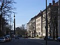
| Brienner Strasse with a view of Karolinenplatz | |
| Basic data | |
| State capital | Munich |
| Townships | Altstadt-Lehel , Maxvorstadt |
| Created | 18th century |
| Hist. Names | Wittelsbach Princes' Way |
| Name received | 1826 |
| Connecting roads | Hofgartenstrasse, Nymphenburger Strasse |
| Cross streets | Theatinerstraße , Oskar-von-Miller-Ring, Ottostraße, Türkenstraße , Barer Straße, Katharina-von-Bora-Straße, Arcisstraße, Luisenstraße, Richard-Wagner-Straße , Augustenstraße , Seidlstraße, Dachauer Straße |
| Places | Odeonsplatz , Wittelsbacherplatz , Amiraplatz, Square of the Victims of National Socialism , Maximiliansplatz , Karolinenplatz , Königsplatz , Stiglmaierplatz |
| Numbering system | Orientation numbering |
| Buildings | Palais Moy , Luitpoldblock |
| Subway station | Odeonsplatz underground station (U3, U4, U5, U6), Königsplatz underground station (U2, U8), Stiglmaierplatz underground station (U1, U7) |
| use | |
| User groups | Pedestrian traffic , bicycle traffic , individual traffic , public transport |
| Technical specifications | |
| Street length | 1.5 km |
The Briennerstraße [ briɛnɐ ] is located in the Old Town and the Maxvorstadt of Munich . It is named after the location of the Battle of Brienne and, along with Ludwigstrasse , Maximilianstrasse and Prinzregentenstrasse, is one of the four major boulevards in the state capital of Bavaria .
Location and course
Brienner Strasse begins on Ludwigstrasse south of Odeonsplatz and runs through Maxvorstadt in a westerly direction. It is first divided by Wittelsbacherplatz , then by the intersection with the Altstadtring , Karolinenplatz and finally Königsplatz until it flows into Stiglmaierplatz . The extension is Nymphenburger Strasse .

View from the Altstadtring towards Odeonsplatz
View from the Altstadtring towards Karolinenplatz
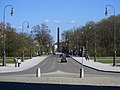
The course over the Königsplatz

View from Koenigsplatz towards Nymphenburger Strasse

Winter view from the Altstadtring towards Karolinenplatz
.jpg)
.jpg)
.jpg)
.jpg)
.jpg)
history
Royal time
Before it was built, Brienner Strasse already existed as the Wittelsbach Princes' Path from the Residenz to Nymphenburg Palace . A northern suburb was planned under King Max I. Joseph , which has been called Maxvorstadt since 1812 . Karl von Fischer and Friedrich Ludwig Sckell expanded the former Fürstenweg into a boulevard and main street. The starting point was the classicist Odeonsplatz , which was moved a few meters to the north as part of the construction of Ludwigstrasse.
The Fürstenweg was renamed Brienner Straße in memory of the Battle of Brienne . This battle took place on January 29, 1814 during the Wars of Liberation . Under the leadership of Blücher , Russian and Prussian troops fought against Napoleon at Brienne-le-Château ; the Bavarian Army was not involved in this battle. The surrounding streets are also reminiscent of the Wars of Liberation: At Karolinenplatz, Barer Strasse crosses Brienner Strasse, named after the battle of Bar-sur-Aube on February 27, 1814. At the eastern end of Königsplatz, Arcisstrasse joins Brienner Strasse from the north after the battle of Arcis-sur-Aube on March 20, 1814. At the intersection between Brienner and Barer Strasse stands the obelisk on Karolinenplatz , which commemorates the Bavarian soldiers who were killed in Napoleon's Russian campaign in 1812, when Bavaria still fought on the French side .
Karl von Fischer tried to break up the rigid grid plan of the Maxvorstadt by means of squares that he planned at places where streets sloping across the street led to the Fürstenweg. These spaces were planned primarily through the expansion of Brienner Strasse itself. This created a free rhythm of the boulevard. Only the Karolinenplatz erupts here: It was designed - as the first square in Munich - as a radiant place. A rectangular square was also laid out at the point where Maximiliansplatz met Brienner Strasse. Here the course of the city fortifications and the city moat required a small bend in Brienner Strasse.
Brienner Strasse was further expanded and completed under Ludwig I. Ludwig I put his ideas of an "Isar-Athens" into practice primarily on Königsplatz. His ideas of living and living in connection with science and nature were also implemented.
Nazi era and World War II
During the Nazi era, Brienner Strasse and the squares on it underwent decisive changes. The expansion of the Brown House , the redesign of Königsplatz and much more took away from Brienner Straße its original character. After the heavy destruction caused by the air raids on Munich in World War II , its appearance in the west between Königsplatz and Stiglmaierplatz changed, and the splendid buildings from the late 19th century in this section were completely lost. But even in the east of the street, numerous aristocratic palaces by well-known architects, such as the Palais Asbeck (Palais Lotzbeck) or the Palais Oettingen-Wallerstein, did not survive the war and the subsequent reconstruction.
After 1945
After 1945, the above-mentioned rectangular square was abandoned due to the expansion of the Oskar-von-Miller-Ring as part of the Altstadtring and the construction of the Square of the Victims of National Socialism . The crossing of the old town ring tears Brienner Straße completely apart.
The place of the victims of National Socialism is opposite the destroyed Wittelsbacher Palais , in which the headquarters and the prison of the Gestapo were located, today the premises of the Bayerische Landesbank . Since the mid-1980s, the memorial to the victims of the Nazi tyranny , a basalt column designed by Andreas Sobeck with a flame always burning behind a steel grille, has been a reminder of the crimes that were committed during the Nazi regime . The square was rebuilt from 2012 to January 2014 and made more visually appealing.
On the initiative of Tina Schmitz, the owner of the Luitpoldblock, landowners and business people around Brienner Strasse founded Brienner Quartier eV in 2007 as an association to jointly promote location marketing . The association calls the area along Brienner Straße, bordered by Odeonsplatz and Platz der Victims of National Socialism , as well as by the old town and Maxvorstadt as Brienner Quartier .
traffic
The eastern section of Brienner Strasse is the most important connection from Ludwigstrasse and the university quarter to the western part of the Altstadtring; only in the opposite direction of travel is there a reasonable alternative. This was used by tram lines 3 and 6 until the underground line went into operation in 1972 . Since the beginning of September 2019, the section between Amiraplatz and Odeonsplatz has been a "fake one-way street". In other words, only regular and sightseeing buses are allowed to travel on this section in this direction, normal traffic is allowed in the opposite direction. With a view to the upcoming Radlring on the Altstadtring, bicycle protection strips have been marked on both sides of the road and parking spaces have been removed. A curiosity is that despite several clearly visible signs "No entry" ( one-way street ), many drivers do not see or ignore these traffic signs even 6 weeks after the traffic routing has been changed and drive through in the direction of Odeonsplatz, even in a column. The protective strips with the one-way street were set up in order to take into account the bicycle traffic on the stretch of Münchner Strasse, which is mostly used by cyclists, and to make it safer. There is less traffic between the Altstadtring and Königsplatz. At the western end between Königsplatz and Stiglmaierplatz, it functions as a collecting road .
Local public transport serves the Odeonsplatz underground station (U3, U4, U5, U6), Karolinenplatz ( tram lines 27 and 28), the Königsplatz underground station (U2) and the Stiglmaierplatz stop (U1, U7, tram lines 20, 21 and 22).
Architecture and landmarks
Brienner Straße is most likely to be in its original form between Oskar-von-Miller-Ring and Karolinenplatz: Freestanding palaces with their own elegance characterize the street scene. To the west of Karolinenplatz, the architecture of the 1950s dominates the picture.
- Palais Moy , (corner of Theatinerstraße, Leo von Klenze 1819)
-
Wittelsbacherplatz
- Palais Ludwig Ferdinand (Leo von Klenze 1825)
- Palais Arco-Zinneberg (Leo von Klenze 1824)
- Luitpoldblock , built in 1812 as the first building outside the city wall by Joseph von Utzschneider (1763–1840), Brienner Straße 11

Luitpoldblock around 1888 on Brienner Strasse

The Luitpoldblock today

View of the Café Luitpold collection - museum for coffee house culture


- Palais Almeida ( Jean Baptiste Métivier , 1823/1824)
- Palais Berchem (Brienner Str. 22, Gabriel von Seidl , 1897/1898)
- House Böhler (Gabriel von Seidl, 1904/1905)
-
Karolinenplatz
- Obelisk (Leo von Klenze, 1833)
- Palais Törring-Seefeld ( Karl von Fischer , 1812)
- Hutschenreuther Villa (1894), seat of the Munich Stock Exchange
- Nazi Documentation Center
-
Koenigsplatz
- Glyptothek (Leo von Klenze, 1816–1830)
- State Collections of Antiquities ( Georg Friedrich Ziebland , 1838–1845)
- Propylaea (Leo von Klenze, 1848–1862)
Public facilities
Museums and exhibition venues
- Museum Collection Café Luitpold , entrance in the palm garden of Café Luitpold, Brienner Straße 11
- Former galleries at Brienner Straße 7
-
- Galerie Wimmer , Munich's oldest art gallery 1825–2016
- Bernheimer Fine Old Masters , art gallery for old masters and for photography (until 2016)
theatre
Colleges
- various institutes of the Ludwig Maximilians University in Munich
- various institutes of the Technical University of Munich
Others
literature
- Klaus Gallas : Munich. From the Guelph foundation of Henry the Lion to the present: art, culture, history . DuMont, Cologne 1979, ISBN 3-7701-1094-3 (DuMont documents: DuMont art travel guide).
- Kamp, Michael and Rau, Marie: Brienner Straße 7. The story of a Munich palace. August Dreesbach Verlag, Munich 2009. ISBN 978-3-940061-28-7
Web links
Individual evidence
- ↑ Johannes Willms: Waterloo: Napoleon's last battle. CH Beck, Munich 2015, ISBN 9783406676604 , footnote 2 for the introduction
- ^ Article in the Süddeutsche Zeitung on the laying of the wreath by Mayor Christian Ude on January 27, 2014
- ^ Obituary: Great loss for Munich. In: www.sueddeutsche.de. July 3, 2017, accessed August 14, 2018 .
- ^ Brienner Quartier eV, registered at the Munich District Court , register no .: VR 201060.
- ↑ About us on the Brienner Quartier eV website
- ^ Galerie Wimmer, oldest gallery in Munich, since 1825. Retrieved on March 14, 2017 .
- ^ Old masters trade: Konrad Bernheimer secures the future of Colnaghi . ( handelsblatt.com [accessed March 14, 2017]).
- ↑ Bernheimer. Retrieved March 14, 2017 (English).
Brienner Strasse with Wittelsbacherplatz , Karolinenplatz and Königsplatz | Ludwigstrasse with Odeonsplatz | Maximilianstrasse with Max-Joseph-Platz | Prinzregentenstrasse with Prinzregentenplatz
Coordinates: 48 ° 8 ′ 42 ″ N , 11 ° 34 ′ 3 ″ E