Odeonsplatz
| Odeonsplatz | |
|---|---|
| Place in Munich | |
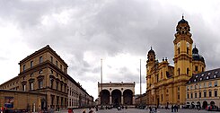
 View from Odeonsplatz to the south on Theatinerkirche , Feldherrnhalle and Residenz |
|
| Basic data | |
| place | Munich |
| District | Old town |
| Created | 1827 |
| Confluent streets | Residenzstrasse , Theatinerstrasse , Brienner Strasse , Ludwigstrasse , Galeriestrasse |
| Buildings | Odeon , Palais Leuchtenberg , bazaar building, Hofgarten gate |
| use | |
| User groups | Pedestrian traffic , bicycle traffic , individual traffic , public transport |
| Space design | Equestrian statue for King Ludwig I. |
The Odeon Square is a square in the old town of Munich at the southern end of the Ludwig street . It is part of the axis Odeonsplatz - Ludwigstraße - Siegestor . The square has been named after a concert hall, the Odeon , which Ludwig I had built on the southwest side of the square since 1827 .
location
Odeonsplatz is located north of the historic old town, on the borderline between the districts of Altstadt-Lehel and Maxvorstadt . It is bordered to the west by the former Odeon (today the seat of the Bavarian Ministry of the Interior ) and the Leuchtenbergpalais (today the seat of the Bavarian Ministry of Finance ) and to the east by the bazaar building with the traditional Café Tambosi (closed at the end of 2016). From the axis of Ludwigstrasse it extends to the west.
In the course of time the name has also been transferred to the Parvis (forecourt) in front of the Feldherrnhalle between the Theatinerkirche and the Residenz , because this occupies the more important position in the urban fabric. To the south, Residenzstrasse goes east and Theatinerstrasse goes west of Feldherrnhalle from Odeonsplatz. Directly behind the Feldherrnhalle is the Viscardigasse , which is still called Drückebergergasse today as a relic of the Nazi past . The broad prospect of Ludwigstrasse runs to the north. The Briennerstraße which begins in the south of the square and runs to the west, there falls not on special. An unnamed street that leads west between the two ministries opens up a view of the Ludwig Ferdinand Palace , which is now the headquarters of Siemens AG . This and Brienner Strasse lead to Wittelsbacherplatz to the west .
history
As part of the fortification of Munich, there were plans for a central square in place of the Schwabinger Tor from around 1790 , which should make the driveway from the Residenz in the Fürstenweg to Nymphenburg Palace (today Brienner Strasse) more attractive. The system in its current form dates back to the special commitment of King Ludwig I return. In 1816, as Crown Prince Leo von Klenze, he commissioned the overall planning of Ludwigstrasse, which also includes Odeonsplatz.
traffic
After the pedestrian zone opened in 1972, the southern part of Odeonsplatz was incorporated into it. In addition, Hofgartenstrasse and Residenzstrasse were later closed to through traffic. The traffic coming from Ludwigstraße in the direction of the old town is now diverted to the Altstadtring via Von-der-Tann-Straße or Brienner Straße .
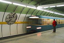
Public transport is through the important station U Odeonsplatz marked when the diameter lines of U3 / U6 to the U4 / U5 cross. The U3 / U6 station, which opened in 1971, was planned by the architect Paolo Nestler , the mosaic on the mezzanine floor was designed by Karl Knappe . The design is similar to the other early stations of the U6, only the fiery red ceramic paneling on the pillars catches the eye as a difference. The U4 / U5 station below, which opened in 1986, was planned by the U-Bahn department itself, the murals were designed by the artist Volker Sander. The underground station is connected to the south head of the U3 / U6 station via a pedestrian tunnel.
Two urban bus routes , the so-called museum route 100 and route 153, also serve the bus stop on the east side of Ludwigstrasse. At night the night bus routes N40, N41 and N45 in the direction of Münchner Freiheit , opposite in the direction of Stachus .
Place for parades
Traditionally, parades take place on larger occasions such as funeral procession (most recently for Franz Josef Strauss in 1988) and victory parades (most recently for the returning Bavarian troops from the Franco-Prussian War in 1871) in Ludwigstrasse in the direction of the Feldherrnhalle. At the equestrian statue of King Ludwig I, the tribune of honor on which the Bavarian king held the victory parade usually stood . Every year the parade of the traditional costume and rifle clubs to the Oktoberfest also takes place along this route.
According to some historians, this tradition was decisive for the march to the Feldherrnhalle as part of the Hitler-Ludendorff putsch on November 9, 1923, which was put down by the state police on Odeonsplatz . In the time of National Socialism , the marches took place there on the anniversary, which continued in the direction of Königsplatz .
Even today, this square is one of the venues for demonstrations or cultural events in Munich next to Marienplatz .
Attractions
- Bazaar building (Odeonsplatz 6–18) ( Leo von Klenze , 1824–1826)
- Odeon : Music academy and concert hall (today the Bavarian State Ministry of the Interior , Odeonsplatz 3) ( Leo von Klenze , 1826–1828)
- Palais Leuchtenberg (today the Bavarian State Ministry of Finance , Odeonsplatz 4) (Leo von Klenze, 1816–1821)
- Theatine Church ( Barelli , Zuccalli , 1663–1692, facade by Cuvilliés , 1765)
- Hofgartentor , Leo von Klenze's first work in Munich 1816/1817, forms the entrance to the Hofgarten on the axis of Brienner Strasse
- Wall mosaic by the sculptor Karl Knappe in the Odeonsplatz underground station from 1970, executed by the Mayer'schen Hofkunstanstalt
Monuments
- Equestrian statue for King Ludwig I ( Max von Widnmann , 1862).
- Feldherrnhalle
- Flagpoles on the forecourt in memory of the 100th birthday of King Ludwig I and the 70th birthday of Prince Regent Luitpold
Public facilities
- Bavarian State Ministry of Finance
- Bavarian State Ministry of the Interior
- There is free WiFi from Stadtwerke München at Odeonsplatz .
literature
- Josef Hugo Biller, Hans-Peter Rasp: Munich: Art & Culture. City guide and manual . 5th, revised. and updated edition. Südwest, Munich 1999, ISBN 3-517-06072-0 .
- Klaus Gallas : Munich. From the Guelph foundation of Henry the Lion to the present: art, culture, history . DuMont, Cologne 1979, ISBN 3-7701-1094-3 (DuMont documents: DuMont art travel guide).
Web links
- muenchen.de: Ludwigstrasse and Odeonsplatz
- Odeonsplatz Munich Interactive 360 ° panorama
Individual evidence
- ↑ Bazaar at the Bavarian State Office for Monument Preservation (with illustration)
- ↑ muenchen.de: M-WLAN at Coubertinplatz in the Olympiapark. Retrieved January 14, 2020 .
Coordinates: 48 ° 8 ′ 32 " N , 11 ° 34 ′ 39" E


