
Tal (Munich)
| valley | |
|---|---|
|
|
|
 |
|
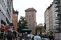
| Valley, seen from the Isartor (from east to west) | |
| Basic data | |
| State capital | Munich |
| Borough | Altstadt-Lehel |
| Name received | before 1273 |
| Connecting roads | Marienplatz , Isartorplatz |
| Cross streets | Burgstrasse, Viktualienmarkt, Sparkassenstrasse, Heiliggeiststrasse, Maderbräustrasse, Hochbrückenstrasse, Radlsteg, Pflugstrasse, Lueg ins Land, Westenriederstrasse, Frauenstrasse, Thomas-Wimmer-Ring |
| Places | Marienplatz, Isartorplatz |
| Numbering system | Orientation numbering |
| use | |
| User groups | Pedestrian traffic , bicycle traffic , individual traffic , public transport |
| Technical specifications | |
| Street length | 470 m |
The valley is a street in the old town of Munich .
The valley (earlier spelling: Thal ) extends over a length of 500 meters between the Old Town Hall on Marienplatz in the west and Isartor in the east. The valley was thus part of the salt road that led from Salzburg and Bad Reichenhall via Munich and Landsberg am Lech into Switzerland . The street was outside the first medieval city wall, which is why the Heilig-Geist-Kirche (Holy Spirit Church) stands at its beginning , which as the church of the first Munich hospital was deliberately laid out with it outside the walls. The name of the street goes back to its lower position. A document from 1253 attests that the street has been so called since at least the 13th century.
Today the street is dominated by retail chains and restaurants . The residents include a branch of the Stadtsparkasse Munich and the Schneider Bräuhaus ( Weißes Bräuhaus until 2015 ). There are numerous listed residential and commercial buildings in the street, including the Kalter-Haus ( Golden 19 ).
In the valley there was an important meeting place for National Socialist politicians and their sympathizers: the Sterneckerbräu (valley 54, today 38). This is where the members of the newly founded German Workers' Party (DAP) met from 1919 - a small German party and the predecessor organization of the NSDAP , to which Adolf Hitler was already a member. In October 1919, Hitler set up the first DAP office in an adjoining room of the Sterneckerbräu, which, however, had to move to the larger Gasthaus Cornelius (Corneliusstrasse 12) due to the increasing number of members. During the National Socialist era , the Sterneckerbräu was converted into a party museum for the NSDAP. The building survived the war. Today there are business premises in the former restaurant. Also in the Sterneckerbräu the founding of the Bavarian Homeland and Royal Association "In Treue fest" took place in 1921, which was banned on February 2, 1934 by the National Socialists and re-established in 1952.

View from 1835. View from east to west. On the left the tower of the Holy Spirit Church, in the middle the old town hall

Today's view at the western beginning of the valley. The street continues to the right to the Isartor
View of the Isartor


Web links
Individual evidence
- ^ Hans Dollinger: The Munich street names. 5th edition. Ludwig Verlag, Munich 2004, ISBN 3-7787-5174-3 , p. 293.
- ↑ Article about the Sterneckerbräu in the valley on www.historisches-lexikon-bayerns.de
Coordinates: 48 ° 8 ′ 9.4 ″ N , 11 ° 34 ′ 46.3 ″ E