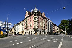
Rosenheimer Strasse
| Rosenheimer Strasse | |
|---|---|
| Street in Munich | |
| Rosenheimer Straße 108 (former Wolfgangseiche restaurant) | |
| Basic data | |
| State capital | Munich |
| district | Haidhausen , Ramersdorf |
| Name received | 1877 |
| Connecting roads | Ludwigsbrücke , Bundesautobahn 8 (Autobahn towards Salzburg) |
| Cross streets | Zeppelinstraße, Lilienstraße, Zellstraße, Am Gasteig, Am Lilienberg, Hochstraße, Schleibingerstraße, Steinstraße, Franziskanerstraße, Balanstraße , Metzstraße, Pariser Straße, Bazeillesstraße, Orleansstraße, Friedenstraße, Sankt-Martin-Straße, Anzinger Straße, Rimstinger Straße, Claudius-Keller-Straße , Melusinenstraße, Wollanistraße, Wageneggerstraße, Maria-Lehner-Straße, Wilramstraße, Kirchseeoner Straße, Herrenchiemseestraße, Frauenchiemseestraße, Chiemgaustraße , Innsbrucker Ring |
| Places | Rosenheimer Platz, Karl-Preis-Platz |
| Numbering system | Orientation numbering |
| Buildings | Müllersches Volksbad , Gasteig , Hilton Munich City, former Motorama, office building Rosenheimer Platz 4 , S-Bahn station Rosenheimer Platz (underground), riot police building, numerous residential buildings listed in the list of monuments |
| use | |
| User groups | Pedestrian traffic , bicycle traffic , individual traffic , public transport |
| Technical specifications | |
| Street length | 3.0 km |
The Rosenheimerstraße is an arterial road in Munich . It is named after the city of Rosenheim , in the direction of which it leads, and runs in the Au-Haidhausen district (district Haidhausen -Süd, which it partially delimits to the south from the Untere Au district), forms the border between the railway line, which is crossed by an underpass, to the east the districts of Berg am Laim and Ramersdorf-Perlach , and continues through the latter district to the federal motorway 8 in the direction of Salzburg.
course
Starting at Müller's Volksbad, the street continues the historic city exit leading over the Ludwigsbrücke to the east. After a few meters, the former Wiener Landstrasse (today the streets Am Gasteig and Innere Wiener Strasse ) branches off to the left . Rosenheimer Straße climbs between the Gasteig cultural center , the Hilton Munich-City hotel and the former Motorama (now a shopping center with hotel; formerly built with the Bürgerbräukeller and the Münchner Kindl -eller) on the eastern high bank of the Isar, crossing the Rosenheimer at a striking office building Square with the underground station of the same name of the Munich S-Bahn , which runs from the Müller Volksbad to the intersection with Orleansstraße under the street, and continues through the one built after 1871, also as an ensemble (E-1-62-000-48) protected French quarter in Haidhausen, which is bordered to the east by Orleansstrasse. In this section there are numerous listed buildings (see list of architectural monuments in Haidhausen ).
To the east of Orleansstrasse, the railway line Munich Hauptbahnhof-Munich East is crossed. a. in the direction of Mühldorf am Inn and Rosenheim . Rosenheimer Straße initially forms the border between the districts of Berg am Laim and Ramersdorf-Perlach , but then completely encompasses the area of the former municipality of Ramersdorf. In the south, as far as Balanstrasse, there is the mixed development of the Kustermannpark on the site of the former Kustermann'schen Eisenwerke, further adjoining a small park, the development of which was discussed in 2017. A mixed development follows up to the intersection with Sankt-Martin-Straße (to the west) and Anzinger Straße (to the east). Between Sankt-Martin-Straße and Claudius-Keller-Straße there are extensive building complexes of the Bavarian riot police on the southwest side of the street . To the east of Melusinenstraße are the ensemble- protected residential complexes built between 1907 and 1927 on Loehleplatz (E-1-62-000-30). On the opposite side of the street there are two listed rental buildings built by Eduard Thon between 1925 and 1927 (No. 214–228 - straight). On its last section up to the Munich-Ramersdorf motorway junction on the Mittlerer Ring , the road, divided into two branches, runs past the center of Alt-Ramersdorf to the west.
literature
- Rambaldi: The Munich street names and their explanation. Piloty & Loehle, Munich 1894, p. 245. (no ISBN)
- Meyer: Höhen-Festpunktnetz, Tiefbauamt - Straßenbau, Munich 1929, pp. 490–491. (no ISBN)
- Mücke / Luther: Münchner Osten - Fundamental studies on urban renewal, Building Department State Capital Munich 1970, (Rosenheimer-, from Orleans, to Anzingerstraße.) (No ISBN)
- Richard Bauer: Munich's street names, Verlag J. Berg, Munich 1983, ISBN 3-7634-0484-8
- Heinrich Habel / Klaus Merten / Michael Petzet / Siegfried von Quast: Munich facades. Town houses of historicism and art nouveau. Munich: Prestel Verlag 1974, ISBN 3-7913-0048-2 , p. 312.
- N. Kreitl: Festschrift 125 years Ramersdorf near Munich, District Committee 30, Munich 1989. (no ISBN)
- Hermann Wilhelm: Haidhauser history volume 1 - Gasteig and Rosenheimer Berg, Meox, Munich, ISBN 3-9800420-2-2
- Hans Dollinger : The Munich street names. 6th edition, Südwest Verlag, Munich 2007, ISBN 978-3-517-08370-4 , p. 262.
Individual evidence
- ↑ https://www.tz.de/muenchen/stadt/ramersdorf-perlach-ort43348/kustermannpark-ob-reiter-beerdigt-bebauungsplaene-8406809.html
Web links
Coordinates: 48 ° 7 ′ 54 ″ N , 11 ° 35 ′ 16 ″ E


