Inner Wiener Strasse
| Inner Wiener Strasse | |
|---|---|
| Street in Munich | |
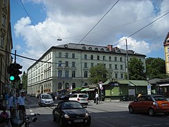
| Inner Wiener Strasse with Hofbräukeller and Wiener Platz (2007) | |
| Basic data | |
| State capital | Munich |
| Borough | Au-Haidhausen |
| Name received | 1856 |
| Connecting roads | Am Gasteig, Ismaninger Strasse |
| Cross streets | Preysingstrasse, Stubenvollstrasse, Steinstrasse, Chorherrstrasse, Kirchenstrasse |
| Places | Wiener Platz , Max-Weber-Platz |
| Numbering system | Orientation numbering |
| Buildings | St. Nikolai am Gasteig , Hofbräukeller |
| U4, U5 | Max-Weber-Platz |
| use | |
| User groups | Pedestrian traffic , bicycle traffic , individual traffic , public transport |
| Road design | Asphalt with tram tracks |
| Technical specifications | |
| Street length | 690 m |
The Innere Wiener Straße is an arterial road in Munich - Haidhausen .
course
The relatively narrow street formed part of the old country road from Munich towards Vienna via Mühldorf am Inn and Braunau . It continues the street Am Gasteig coming from the Ludwigsbrücke , the first Isar crossing in Munich, from the junction of Preysingstraße in a north-easterly direction.
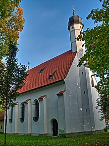
It leads past the church of St. Nikolai am Gasteig , which belonged to a former leprosy hospital. In its further course it touches the Hofbräukeller , which was next to the brewery that was demolished at the end of the 20th century and replaced by residential buildings. It runs over Wiener Platz to Max-Weber-Platz . There it ends at the intersection with the east to Federal Highway 94 ( European Route 552 secondary,) today Einsteinstraße (from 1955, before "Outer Wiener Straße"), the northbound Ismaninger road and the extension of the Maximilianstrasse coming from the west Max Planck Street .
Tram line 17 (formerly 16) runs through the street . At Max-Weber-Platz it crosses several other tram lines. The subway station of the same name is located under Max-Weber-Platz and branches off the U4 and U5 subway lines.
designation
The name of the street goes back to 1856.
Architectural monuments under monument protection
- No. 1 (the core of the late Gothic church of St. Nicholas)
- No. 3a (part of the Maximilians and Gasteig facilities )
- No. 3–9 odd (fence of the garden of the Hofbräukeller )
- No. 17–19 (Hofbräukeller)
- No. 18 (Baroque-style apartment building at the beginning of the 20th century)
- No. 22–26 straight (historicizing tenement houses from 1913)
- No. 28 apartment building around 1900
- No. 30 tenement house, 1885
- No. 32 apartment building around 1860/70
- No. 36 Tenement House, New Renaissance, 1878
- No. 38 tenement house around 1880
- No. 40 tenement house around 1900 with bay windows and rich stucco
- No. 42 tenement house, 1893
- No. 44 tenement house, end of the 19th century.
- No. 46 apartment building, stately corner building with two bay windows, around 1900
- No. 50 suburban house, classicistic, mid-19th century.
- No. 52 apartment building with oriel tower, around 1900
- No. 57 apartment building, 1901
- No. 59 Tenement House, 1895
- No. 60 apartment building, corner building with dome and bay windows, 1900
- No. 61 tenement house, heightened in 1856, 1894
literature
- Hans Dollinger : The Munich street names. 6th edition, Südwest Verlag, Munich 2007, ISBN 978-3-517-08370-4 , p. 127.
- Winfried Nerdinger: Theodor Fischer - Architect and Urban Builder 1862-1938, exhibition catalog, Ernst and Son, Publishing House for Architecture and Technical Sciences, Berlin 1988, ISBN 3-433-02085-X , esp. P. 154.
Web links
- Inner Wiener Strasse in the Munich Wiki
Coordinates: 48 ° 7 '57 " N , 11 ° 35' 26" E


