Max-Planck-Strasse
| Max-Planck-Strasse | |
|---|---|
| Street in Munich | |
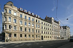
| Facade view of the buildings along the street with even house numbers. | |
| Basic data | |
| State capital | Munich |
| Borough | Au-Haidhausen |
| Hist. Names | Outer Maximilianstrasse |
| Name received | 1956 |
| Connecting roads | Maximilianstrasse , Einsteinstrasse |
| Cross streets | Sckellstrasse, Maria-Theresia-Strasse, Innere Wiener Strasse , Ismaninger Strasse |
| Places | Max-Weber-Platz |
| Numbering system | Orientation numbering |
| Buildings | Maximilianeum , Maximilianswerk |
| Subway | U 4 / U 5, Max-Weber-Platz underground station |
| use | |
| User groups | Pedestrian traffic , bicycle traffic , individual traffic , public transport |
| Road design | Cobblestones, asphalt |
| Technical specifications | |
| Street length | 440 m |
The Max-Planck-Straße is a city road in the district Haidhausen of Munich . It forms part of the direct connection from the Altstadtring to the Passau motorway (A 94).
course
The relatively short street (formerly: Äußere Maximilianstraße) is the eastern continuation of Maximilianstraße . It begins at the Maximiliansbrücke , overcomes the heights of the eastern Isar high bank on two separate, semicircular lanes through the Maximiliansanlagen , which comprise the Maximilianeum building complex , crosses the high street of Sckellstraße (to the south) and Maria-Theresia- Street (to the north) and continues with Wilhelminian-style buildings to Max-Weber-Platz , where it meets the inner Wiener Straße / Ismaninger Straße street . With the exception of No. 12, the corner houses of the streets crossing each have house numbers assigned to the cross streets. Beyond Max-Weber-Platz, Einsteinstraße (formerly: Äußere Wiener Straße) extends the street in the direction of the Bundesautobahn 94. "The short street ... is characterized by richly structured residential buildings from the 1870s in transitional forms from late classicism to neo-renaissance" . The corner houses Sckellstrasse 6 and Maria-Theresia-Strasse 1. House No. 7 was stripped of its structure.
Tram line 19 and tram line 21 of the Münchner Verkehrsgesellschaft mbH (MVG) run on the street , with the Maximilianeum stop. The underground lines U 4 and U 5 of trunk line 3 run under the street in the tunnel and branch off at Max-Weber-Platz.
history
Plans to expand a connection on what is now Max-Planck-Strasse were drawn up in connection with the construction of Maximilianstrasse around 1850. The route is included in the project of a road from the residence to Haidhausen by Matthias Berger (1851) and in the 2nd project by Friedrich Bürklein for Maximilianstraße from 1852 (there already with the roundabout on the slope of the Isar high bank). The eastern part of the street was built in the 1870s.
designation
The street is named after the physicist Max Planck (1858–1947). The street was named in 1956.
Architectural monuments on Max-Planck-Strasse
- No. 1 Maximilianeum , 1857–1874 by Friedrich Bürklein , on a high slope terrace on the eastern high bank of the Isar, forms the visual end of Maximilianstrasse .
- No. 2 Maximilianswerk , run-of-river power station on the Auer Mühlbach , castle-like neo-baroque building on the Maximiliansanlagen , built in 1895 by Carl Hocheder .
- No. 3 Late Classicist, richly structured tenement house, built by Albert Bruckmaier in 1877/78.
- No. 4 Late Classicist apartment building, built in 1876 by Robert Stürmer and Max Häusler.
- No. 5 Late Classicist, richly structured and stuccoed tenement house facade, 1877/78 by Albert Bruckmaier.
- No. 6 Late Classicist tenement house with rich stucco decoration, built in 1876 by Robert Stürmer and Max Häusler.
- No. 8 richly structured neo-renaissance tenement house with stucco decoration, by Albert Bruckmaier around 1873; forms a group with No. 10.
- No. 10 richly structured neo-renaissance tenement house with stucco decoration, 1873 by Albert Bruckmaier.
- No. 12 corner house, stately neo-renaissance building, richly structured, with echoes of the Maximilian style , 1873 by Albert Bruckmaier.
All buildings mentioned are included in the list of monuments.
See also: List of architectural monuments in Haidhausen with images of the buildings
literature
- Karl von Rambaldi : The Munich street names and their explanation. Piloty & Loehle, Munich 1894, p. 179. (Old name of the street, Maximilianstraße, Äußere. Named in 1867.)
- E. Luther (Ed.): Munich's street names. 1st edition. 1965, Building Department State Capital Munich, p. 164. (Year listed for the first time.)
- Richard Bauer, Herbert Schneider: The Munich street names. _ Edition 1983, Verlag Berg, Munich, ISBN 3-7634-0484-8 , p. 138.
- Hans Dollinger: The Munich street names. 6th edition 2007, Südwest Verlag, Munich, ISBN 978-3-517-08370-4 , p. 207.
- Hans Dollinger: The Munich street names. 8th edition. 2016, Belser Verlag, Munich, ISBN 978-3-7630-4039-1 , p. 212. (The currently - 2019 - most current edition.)
- Heinrich Habel, Klaus Merten, Michael Petzet , Siegfried von Quast: Munich facades. Town houses of historicism and art nouveau. Prestel Verlag, Munich 1974, ISBN 3-7913-0048-2 , p. 302 and Fig. 229.
Individual evidence
- ^ Hans Dollinger: Die Münchner Straßenennamen, 6th edition 2007, Südwest Verlag, Munich, ISBN 978-3-517-08370-4 , p. 207
- ^ Heinrich Habel, Klaus Merten, Michael Petzet, Siegfried von Quast: Münchner Fassaden. Town houses of historicism and art nouveau. Prestel Verlag, Munich 1974, ISBN 3-7913-0048-2 , p. 302
- ↑ Florian Koch: Maximilianstraße, in: Winfried Nerdinger (Ed.): Between Glaspalast and Maximilianeum, Architecture in Bavaria at the time of Maximilian II. 1848 - 1864, exhibition catalogs of the Architecture Museum of the Technical University of Munich and the Munich City Museum No. 10, 1997, p . 277 ff, 284, 285, with ill., Without ISBN
Web links
Coordinates: 48 ° 8 ′ 8 ″ N , 11 ° 35 ′ 49 ″ E


