Maximiliansanlagen


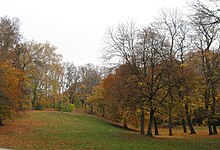
The Maximiliansanlagen are parks and gardens in the Munich districts of Bogenhausen and Haidhausen between Ludwigsbrücke and Max-Joseph-Brücke . The central point is the 38 meter high Angel of Peace .
The Maximiliansanlagen were laid out between 1856 and 1866 under the direction of Carl von Effner , the client and namesake was King Maximilian II. The extension was created by Jakob Möhl . The area was previously used as a sheep pasture, the slopes were partly badly eroded .
The approximately 30 hectare long park has numerous terraces and is located on the right bank of the Isar . This connected the eastern plateau to the city at the time.
In 1894 a park extension was set up at the foot of the steep slope. The park is separated from Prinzregentenstrasse and Max-Planck-Strasse (formerly Äußere Maximilianstrasse, continuation of Maximilianstrasse to the east).
The south of the Maximilianeum situated Gasteig plants were included over time in the Maximilian Park with a part thereof is used as a municipal sports complex today.
The park is administered by the English Garden administration.
Via the König-Ludwig-Weg in the Maximiliansanlagen you come to the monument to King Ludwig II by Anton Rückel , which was erected in 1967 and initiated a citizens' movement. It stands near the site of the Munich Festival Hall , which was never built by the architect Gottfried Semper , and is commemorated in the base.
photos
Every March there is a unique natural spectacle in the Maximiliansanlage: the bloom of the star hyacinths .
The star hyacinths bloom in March every year
The star hyacinths bloom in March every year
Web links
- www.schloesser.bayern.de (Bavarian Administration of State Palaces, Gardens and Lakes): Maximiliansanlagen München
- www.muenchen.de: Maximiliansanlagen
Coordinates: 48 ° 8 ′ 20.6 " N , 11 ° 35 ′ 43.8" E


