
Bayerstrasse
| Bayerstrasse | |
|---|---|
|
|
|
 |
|
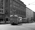
| Beginning of Bayerstrasse at Stachus | |
| Basic data | |
| State capital | Munich |
| Townships | Ludwigsvorstadt-Isarvorstadt , Schwanthalerhöhe |
| Hist. Names | Pasinger Strasse, Landsberger Strasse |
| Name received | before 1823 |
| Connecting roads | Neuhauser Strasse , Landsberger Strasse |
| Cross streets | Sonnenstrasse , Zweigstrasse, Schillerstrasse , Bahnhofplatz, Senefelderstrasse, Goethestrasse , Mittererstrasse, Paul-Heyse-Strasse, Herman-Lingg-Strasse, Zollstrasse, Martin Greif-Strasse, Kurt-Haertel-Passage |
| Places | Stachus , Bahnhofplatz |
| Numbering system | Orientation numbering |
| Buildings | Central station , Bayerpost |
| Underground lines U1 , U2 , U4 , U5 , U7 | Hauptbahnhof underground station |
| use | |
| User groups | Pedestrian traffic , bicycle traffic , car traffic , public transport |
| Technical specifications | |
| Street length | 1.3 km |
The Bayerstraße is a city road in the southern Munich station district. It runs from Stachus as a continuation of Neuhauser Straße to the west and south from the main train station to Grasserstraße, from which it turns into Landsberger Straße .
The architectural monuments 12 ( Bayerpost ), 14, 27, 57/59, 77a, 77, 79, 103, 107 are located on it, see also: List of architectural monuments in Ludwigsvorstadt . The administrative court in Munich , the Mathäser Kino, the Städtische Sing- und Musikschule München , tz , 95.5 Charivari , the “Pressehaus Bayerstraße” and the Spatenkeller are also up to her .

Bayerpost
Bayerstrasse 25 (1982)

Bayerstrasse 27

Bayerstrasse 57-59

Bayerstrasse 79

Bayerstrasse 107

Mathäser


Tram lines 16, 17, 18, 19, 20 and 29 run in Bayerstrasse .
history
The current name of the street probably goes back to the Bavarian tribe , although the n is likely to have worn off in linguistic usage.
Web links
Individual evidence
- ^ A b Hans Dollinger: The Munich street names. 5th edition. Ludwig Verlag, Munich 2004, ISBN 3-7787-5174-3
Coordinates: 48 ° 8 ′ 20.6 ″ N , 11 ° 33 ′ 9.7 ″ E