
List of districts of Munich
The districts in Munich are historically grown areas in Munich that have their own name. These designations reflect the spatial ideas of the population, but only partially coincide with the official city districts of Munich. There are also many other names for smaller territorial units in the city. Together, the districts make up the cityscape of the entire city.
City structure
In 1992 a reorganization of the official urban district structure was carried out. This resulted in 24 districts, to which Laim was added as the 25th district in 1996 . However, this administrative structure of the urban area only partially corresponds to the historically grown districts of Munich. The originally mostly independent communities, which were incorporated into Munich from the middle of the 19th century , formed the basis for today's structure. In the course of time, however, this was repeatedly adapted to the further urban development. B. new quarters or settlements have emerged. Several former municipalities were often merged into one city district. Occasionally, the area of an originally independent municipality now extends over two or more city districts (e.g. near Giesing , Schwabing and Sendling ).
The districts of the city of Munich come closest to the established urban structure, as the district boundaries mostly arose directly from the boundaries of the incorporated communities. However, all districts that were incorporated before 1890 are assigned to the Munich district, only from then on did the incorporated areas retain their district names.
List of neighborhoods
This list gives an overview of the historical district names of Munich and assigns them to the respective official city districts in which they are located today. As additional information, districts (sub-areas of a district with their own identity, sometimes also historical localities) and settlements (new development areas that are subject to uniform planning) are listed that are located in these districts.
The delimitation of what is a separate district and what is a subordinate quarter is often handled differently. This list follows a common practice of the city of designating districts as the places that are included in the names of the city districts and that usually correspond to the incorporated municipalities. Smaller quarters are then assigned to these larger districts. However, since several incorporated communities and places are only summarized under the name of one of these places in district 13, the subdivision of the Association for District Culture in the Munich Northeast eV was taken over for this district.
Situation maps
The following map series should help to classify the location of the city districts, quarters and settlements in the context of the various official divisions of the city of Munich:
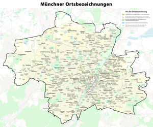
City districts, quarters and settlements

Official structure: city districts

Official structure: parts of the city district

Comparison of the districts with today's city districts

Official structure until 1992: city districts


See also
- List of the boroughs of Munich
- List of the municipalities of Munich
- Incorporation into the city of Munich
- The emergence of the Munich cityscape
literature
- Helmuth Stahleder : From Allach to Zamilapark. Names and basic historical data on the history of Munich and its suburbs . Munich: Buchendorfer, 2001, ISBN 3-934036-46-5
Web links
- City districts on the city portal muenchen.de of the state capital Munich
Individual evidence
- ↑ see e.g. districts. In: Stadtportal muenchen.de. State capital Munich, accessed on May 21, 2013 .
- ↑ Munich's northernmost corner. In: nordostkultur-muenchen.de. Association for District Culture in the Munich Northeast eV, accessed on May 21, 2013 .